Washburne State Wayside, State park in Oregon, United States
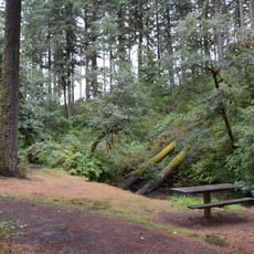
Washburne State Wayside was a day-use park 4 miles (6 km) northwest of Junction City, Oregon, on the Lane–Benton county line along Oregon Route 99W. It held picnic tables, a restroom, interpretive signs about the Applegate Trail, and a nature trail into second-growth Douglas fir. The land is now privately owned and the large trees have been logged off.
Oregon bought the land for the wayside in 1926 from William C. and Mae E. Washburne, whose surname the site carried. It sat on the Lane–Benton county line 4 miles northwest of Junction City and was run by the Oregon Parks and Recreation Department as a rest stop on Route 99W and an Applegate Trail interpretive site. It is no longer a park; the land is privately owned and the large trees were logged off.
The wayside was named for William C. and Mae E. Washburne, who sold the land to the state in 1926. Its signs interpreted the Applegate Trail, the southern emigrant route into Oregon, and travelers on Route 99W stopped to read them. The land is now privately owned and the large trees have been logged off.
The wayside sat 4 miles (6 km) northwest of Junction City on the Lane–Benton county line, beside Oregon Route 99W, and served as a rest stop for highway travelers. Its picnic tables, restroom, nature trail and Applegate Trail interpretive signs are gone: the land is now privately owned and the large trees have been logged off.
The wayside was named for William C. and Mae E. Washburne, who sold the land to the state in 1926. It stood on the Lane–Benton county line, and its nature trail entered second-growth Douglas fir; the site is now privately owned and the large trees have been logged off.
The community of curious travelers
AroundUs brings together thousands of curated places, local tips, and hidden gems, enriched daily by 94,233 contributors worldwide.