Enable Location

We need your location to show you interesting places around you

Discover nearby places

Find interesting locations and hidden gems around you

Precise directions

Get accurate directions and distances to places

Your location is never shared with other users. It's only used when you tap the location button.

Oregon Railway and Navigation Company Bridge

Log in to your account

Start exploring — it's free

Trusted by 62,337 travelers worldwide

Continue with Google
Continue with Apple
or

We will send you a code to connect

By continuing, you accept our Terms and Conditions and our Privacy Policy

Check your inbox

We've sent a pincode in your inbox. Please enter the code below.

Oregon Railway and Navigation Company Bridge

Oregon Railway and Navigation Company Bridge, railroad bridge in Lane County, Oregon

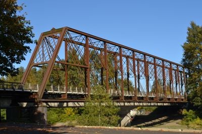
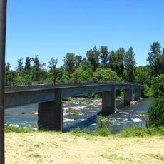
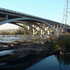
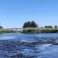
The Oregon Railway and Navigation Company Bridge is an iron arch structure built in 1887 that crosses the McKenzie River near Coburg. The structure features a sturdy design with concrete supports and a steel frame typical of late 19th century railway engineering.

The original structure at this site was a wooden covered bridge built in 1891, measuring about 380 feet (116 meters) long, which carried wagons and early settlers across the river. The current iron bridge was built in 1887 elsewhere and relocated to this spot over the McKenzie River in 1907 to support expanding rail traffic.

The bridge takes its name from the Oregon Railway and Navigation Company, the historical railroad that once operated this route. Today it stands as a quiet landmark reminding visitors of the era when railways shaped the region's economic growth.

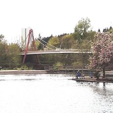
The bridge is accessible to pedestrians and cyclists and offers views of the McKenzie River and surrounding landscape. Nearby is Armitage County Park located about five miles north of Eugene, providing a quiet setting to explore the natural area.

The bridge was originally built at a different location over the John Day River before being relocated to its current position in 1907. This relocation of such a large structure demonstrates the importance railroad connections held for regional development.

The community of curious travelers

AroundUs brings together thousands of curated places, local tips, and hidden gems, enriched daily by 60,000 contributors worldwide.

Start exploring
Location
Inception
1887
GPS coordinates
44.11226,-123.04701
Latest update
February 9, 2026 07:40
Around this place
Autzen Stadium
United States of America

Autzen Stadium

6.2 km
Pre's Trail
United States of America

Pre's Trail

7 km
Shelton McMurphey Johnson House
United States of America

Shelton McMurphey Johnson House

7.2 km
Wayne L. Morse United States Courthouse
United States of America

Wayne L. Morse United States Courthouse

7.5 km
Hatfield-Dowlin Complex
United States of America

Hatfield-Dowlin Complex

6.2 km
Ya Po Ah Terrace
United States of America

Ya Po Ah Terrace

7.2 km
Mims House
United States of America

Mims House

6.2 km
Ferry Street Bridge
United States of America

Ferry Street Bridge

6.7 km
Eugene City Hall
United States of America

Eugene City Hall

7.6 km
Big "O"
United States of America

Big "O"

7.1 km
Eugene Science Center
United States of America

Eugene Science Center

6.5 km
Washburne Historic District
United States of America

Washburne Historic District

7.5 km
Dave and Lynn Frohnmayer Pedestrian and Bicycle Bridge
United States of America

Dave and Lynn Frohnmayer Pedestrian and Bicycle Bridge

7 km
Willakenzie Grange Hall
United States of America

Willakenzie Grange Hall

3.6 km
Whilamut Passage Bridge
United States of America

Whilamut Passage Bridge

7.4 km
Knickerbocker Bicycle Bridge
United States of America

Knickerbocker Bicycle Bridge

7.5 km
Peter DeFazio Bridge
United States of America

Peter DeFazio Bridge

6.8 km
Dads' Gates
United States of America

Dads' Gates

7.6 km
Coburg Historic District
United States of America

Coburg Historic District

3.1 km
Elmer Harlow House
United States of America

Elmer Harlow House

4.9 km
Lane Hotel
United States of America

Lane Hotel

7.3 km
Wallace and Glenn Potter House
United States of America

Wallace and Glenn Potter House

7.5 km
U.S. Post Office
United States of America

U.S. Post Office

7.5 km
Chase Gardens Residential Grouping
United States of America

Chase Gardens Residential Grouping

6 km
Robert E. Campbell House
United States of America

Robert E. Campbell House

6.5 km
Howard A. Hall House
United States of America

Howard A. Hall House

7.4 km
David Minor Theater & Pub
United States of America

David Minor Theater & Pub

7.3 km
East Skinner Butte Historic District
United States of America

East Skinner Butte Historic District

7 km
Show the full map
« Oregon Railway and Navigation Company Bridge - railroad bridge in Lane County, Oregon » is provided by Around Us (aroundus.com). Images and texts are derived from Wikimedia project under a Creative Commons license. You are allowed to copy, distribute, and modify copies of this page, under the conditions set by the license, as long as this note is clearly visible.

Discover hidden gems everywhere you go!

From secret cafés to breathtaking viewpoints, skip the crowded tourist spots and find places that match your style. Our app makes it easy with voice search, smart filtering, route optimization, and insider tips from travelers worldwide. Download now for the complete mobile experience.

Around Us App Screenshot

A unique approach to discovering new places

Le Figaro

All the places worth exploring

France Info

A tailor-made excursion in just a few clicks

20 Minutes

Around Us
Travel Guide & Maps
Download

Send to your phone

QR Code
1

Open the camera app on your mobile.

2

Point at the QR code with your camera. A notification will appear.

3

Tap the notification to open the link.