Fort Hoskins

Log in to your account

AroundUs is a community-driven map of interesting places, built by curious explorers like you. It grows with every review, story, and photo you share.
Connect to save your favorite spots, contribute locations, and create personalized routes.
By continuing, you accept our Terms and Conditions and our Privacy Policy
Add to collection
Map
Suggest a change
Share

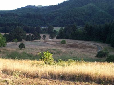
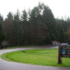
Fort Hoskins, Military facility in Kings Valley, Oregon.

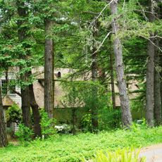
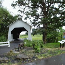
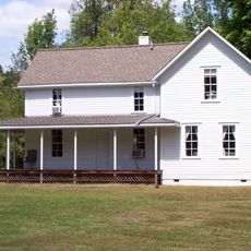
Fort Hoskins is a historic military installation in Kings Valley that occupies more than 100 acres and preserves original building foundations along with several structures restored to their original positions. The site includes walking trails through woodland and meadow areas, with informational displays explaining the fort's role and layout.

The United States Army built this fort in 1856 as part of a chain of three military posts designed to monitor the Coastal Indian Reservation in Oregon Territory. It remained active during decades when American westward expansion fundamentally altered the region's indigenous populations and landscapes.

The fort served as a posting station where officers conducted daily military operations and interactions with local indigenous peoples during a period of territorial expansion. This role shaped how people viewed the landscape and the relationships that formed across cultures in this region.

The site is open to visitors who can walk at their own pace through the grounds and read the interpretive signs located along the trails. A group picnic area with tables, grilling facilities, and basic amenities is available for reservation if you plan a larger gathering.

Several officers who later became prominent Civil War generals, including Christopher Columbus Augur and Phil Sheridan, served at this remote outpost early in their military careers. Their postings here before achieving national recognition offer an unexpected connection between this quiet location and major events in American military history.

Location: Benton County

Inception: 1856

Website: https://co.benton.or.us/parks/page/fort-hoskins-historical-park

GPS coordinates: 44.67400,-123.46000

Latest update: December 12, 2025 12:08

Photos
Around this place
Reser Stadium
United States of America

Reser Stadium

19.1 km
Gill Coliseum
United States of America

Gill Coliseum

19 km
Memorial Union
United States of America

Memorial Union

18.8 km
Dixon Recreation Center
United States of America

Dixon Recreation Center

19 km
Peavy Arboretum
United States of America

Peavy Arboretum

18.1 km
Irish Bend Covered Bridge
United States of America

Irish Bend Covered Bridge

17.4 km
Oregon State University Radiation Center
United States of America

Oregon State University Radiation Center

18.2 km
Bell Field
United States of America

Bell Field

18.9 km
Corvallis-Benton County Public Library
United States of America

Corvallis-Benton County Public Library

19.7 km
Ellmaker State Wayside
United States of America

Ellmaker State Wayside

15.1 km
Community Hall
United States of America

Community Hall

19 km
LaSells Stewart Center
United States of America

LaSells Stewart Center

19.2 km
Harris Bridge
United States of America

Harris Bridge

10.5 km
Ritner Creek Bridge
United States of America

Ritner Creek Bridge

6.2 km
Riley–Cutler House
United States of America

Riley–Cutler House

10.5 km
First Congregational Church
United States of America

First Congregational Church

19.6 km
George Taylor House
United States of America

George Taylor House

19.6 km
Dr. Ralph Lyman Bosworth House
United States of America

Dr. Ralph Lyman Bosworth House

19.3 km
John Bexell House
United States of America

John Bexell House

18 km
J. R. Bryson House
United States of America

J. R. Bryson House

19.6 km
Camp Arboretum Sign Shop
United States of America

Camp Arboretum Sign Shop

18.1 km
Charles King House
United States of America

Charles King House

10.4 km
J. Leo Fairbanks House
United States of America

J. Leo Fairbanks House

17.9 km
Charles Gaylord House
United States of America

Charles Gaylord House

19.7 km
Isaac King House and Barn
United States of America

Isaac King House and Barn

2.7 km
Lewis G. Kline House
United States of America

Lewis G. Kline House

19.5 km
George W. Bethers House
United States of America

George W. Bethers House

16.2 km
Corvallis High School
United States of America

Corvallis High School

18.9 km
Show the full map
Reviews

Visited this place? Tap the stars to rate it and share your experience / photos with the community! Try now! You can cancel it anytime.

« Fort Hoskins - Military facility in Kings Valley, Oregon » is provided by Around Us (aroundus.com). Images and texts are derived from Wikimedia project under a Creative Commons license. You are allowed to copy, distribute, and modify copies of this page, under the conditions set by the license, as long as this note is clearly visible.

Discover hidden gems everywhere you go!

From secret cafés to breathtaking viewpoints, skip the crowded tourist spots and find places that match your style. Our app makes it easy with voice search, smart filtering, route optimization, and insider tips from travelers worldwide. Download now for the complete mobile experience.

Around Us App Screenshot

A unique approach to discovering new places

Le Figaro

All the places worth exploring

France Info

A tailor-made excursion in just a few clicks

20 Minutes