Enable Location

We need your location to show you interesting places around you

Discover nearby places

Find interesting locations and hidden gems around you

Precise directions

Get accurate directions and distances to places

Your location is never shared with other users. It's only used when you tap the location button.

Harris Bridge

Log in to your account

Start exploring — it's free

Trusted by 61,886 travelers worldwide

Continue with Google
Continue with Apple
or

We will send you a code to connect

By continuing, you accept our Terms and Conditions and our Privacy Policy

Check your inbox

We've sent a pincode in your inbox. Please enter the code below.

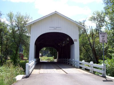
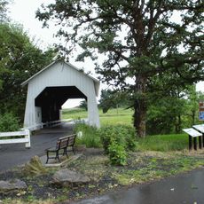
Harris Bridge, Covered bridge in Benton County, US.

Harris Bridge is a covered wooden bridge crossing Mary's River, featuring lattice-pattern support beams and protective exterior walls that enclose the entire structure. The design uses diagonal timbers organized in a truss system that distributes weight and provides stability.

Built in 1922, this bridge emerged during an era when covered designs protected wooden components from weather and extended structural longevity. It represents a standard construction approach for river crossings in the region during the early 20th century.

The bridge reflects early 20th-century craftsmanship visible in its wooden joinery and construction methods that solved practical transportation challenges of the time. The location attracts people interested in traditional building techniques and regional engineering history.

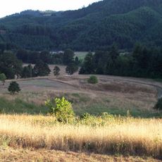
The bridge remains open to vehicle traffic, allowing easy access by car for visitors who want to see it up close. Fishing areas along the riverbanks and surrounding grounds offer opportunities to spend time near the structure and explore the natural setting.

The Town Lattice design employs a specific pattern of diagonal wooden members that distributes loads efficiently without requiring massive beams. This construction method was economical and proved remarkably durable for bridges built during that period.

The community of curious travelers

AroundUs brings together thousands of curated places, local tips, and hidden gems, enriched daily by 60,000 contributors worldwide.

Start exploring
Location
GPS coordinates
44.57970,-123.45900
Latest update
December 14, 2025 18:13
Around this place
Reser Stadium
United States of America

Reser Stadium

14.3 km
Marys Peak
United States of America

Marys Peak

11.2 km
Gill Coliseum
United States of America

Gill Coliseum

14.3 km
Memorial Union
United States of America

Memorial Union

14.4 km
Fort Hoskins
United States of America

Fort Hoskins

10.5 km
Dixon Recreation Center
United States of America

Dixon Recreation Center

14.4 km
Irish Bend Covered Bridge
United States of America

Irish Bend Covered Bridge

12.6 km
Oregon State University Radiation Center
United States of America

Oregon State University Radiation Center

13.6 km
Bell Field
United States of America

Bell Field

14.4 km
Corvallis-Benton County Public Library
United States of America

Corvallis-Benton County Public Library

15.5 km
Whiteside Theatre
United States of America

Whiteside Theatre

15.7 km
Ellmaker State Wayside
United States of America

Ellmaker State Wayside

14.3 km
Community Hall
United States of America

Community Hall

14.7 km
United States of America

LaSells Stewart Center

14.5 km
Corvallis Arts Center
United States of America

Corvallis Arts Center

15.5 km
Benton County Courthouse
United States of America

Benton County Courthouse

15.7 km
First Congregational Church
United States of America

First Congregational Church

15.5 km
Dr. Henry S. Pernot House
United States of America

Dr. Henry S. Pernot House

15.6 km
John Bexell House
United States of America

John Bexell House

13.8 km
J. R. Bryson House
United States of America

J. R. Bryson House

15.6 km
Charles King House
United States of America

Charles King House

86 m
Charles and Ibby Whiteside House
United States of America

Charles and Ibby Whiteside House

15.4 km
J. Leo Fairbanks House
United States of America

J. Leo Fairbanks House

13.7 km
Charles Gaylord House
United States of America

Charles Gaylord House

15.5 km
Isaac King House and Barn
United States of America

Isaac King House and Barn

10.3 km
Lewis G. Kline House
United States of America

Lewis G. Kline House

15.5 km
George W. Bethers House
United States of America

George W. Bethers House

8 km
Corvallis High School
United States of America

Corvallis High School

15.3 km
Show the full map
« Harris Bridge - Covered bridge in Benton County, US » is provided by Around Us (aroundus.com). Images and texts are derived from Wikimedia project under a Creative Commons license. You are allowed to copy, distribute, and modify copies of this page, under the conditions set by the license, as long as this note is clearly visible.

Discover hidden gems everywhere you go!

From secret cafés to breathtaking viewpoints, skip the crowded tourist spots and find places that match your style. Our app makes it easy with voice search, smart filtering, route optimization, and insider tips from travelers worldwide. Download now for the complete mobile experience.

Around Us App Screenshot

A unique approach to discovering new places

Le Figaro

All the places worth exploring

France Info

A tailor-made excursion in just a few clicks

20 Minutes

Around Us
Travel Guide & Maps
Download

Send to your phone

QR Code
1

Open the camera app on your mobile.

2

Point at the QR code with your camera. A notification will appear.

3

Tap the notification to open the link.