Enable Location

We need your location to show you interesting places around you

Discover nearby places

Find interesting locations and hidden gems around you

Precise directions

Get accurate directions and distances to places

Your location is never shared with other users. It's only used when you tap the location button.

Marys Peak

Log in to your account

Start exploring — it's free

Trusted by 62,479 travelers worldwide

Continue with Google
Continue with Apple
or

We will send you a code to connect

By continuing, you accept our Terms and Conditions and our Privacy Policy

Check your inbox

We've sent a pincode in your inbox. Please enter the code below.

Marys Peak

Marys Peak, Mountain summit in Oregon Coast Range, US

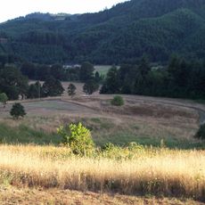
Marys Peak is the highest point in Oregon's Coast Range, rising to approximately 4,097 feet. The summit offers views of the Pacific Ocean to the west and the Cascade Range peaks to the east.

Native peoples of Oregon long used this peak's natural resources, gathering plants essential to their traditional way of life. European settlers later explored the region, and the mountain became a recognized landmark in the landscape.

The summit serves as a gathering point where visitors throughout the year come to photograph the snow-capped peaks of the Cascade Range stretching into the distance. The location draws people who want to appreciate the expansive mountain vistas and take in the scale of the range.

A paved road reaches the summit parking area, making access straightforward for most vehicles. Visitors should check current conditions at higher elevations and verify whether any permits are needed before driving up.

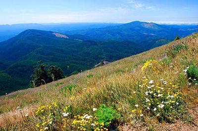
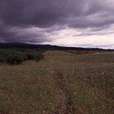
Multiple ecosystems meet on this mountain within a remarkably small area, creating unexpected diversity. Visitors moving up the slopes pass from dense forests into alpine meadows that turn purple and white with glacier lilies and violets each spring.

The community of curious travelers

AroundUs brings together thousands of curated places, local tips, and hidden gems, enriched daily by 60,000 contributors worldwide.

Start exploring
Location
GPS coordinates
44.50437,-123.55262
Latest update
December 8, 2025 13:43
Around this place
Reser Stadium
United States of America

Reser Stadium

22.4 km
Gill Coliseum
United States of America

Gill Coliseum

22.5 km
Memorial Union
United States of America

Memorial Union

22.7 km
William L. Finley National Wildlife Refuge
United States of America

William L. Finley National Wildlife Refuge

21.2 km
Fort Hoskins
United States of America

Fort Hoskins

20.3 km
Dixon Recreation Center
United States of America

Dixon Recreation Center

22.7 km
Irish Bend Covered Bridge
United States of America

Irish Bend Covered Bridge

21.1 km
Oregon State University Radiation Center
United States of America

Oregon State University Radiation Center

22 km
Bell Field
United States of America

Bell Field

22.7 km
Corvallis-Benton County Public Library
United States of America

Corvallis-Benton County Public Library

23.9 km
Ellmaker State Wayside
United States of America

Ellmaker State Wayside

13.8 km
Community Hall
United States of America

Community Hall

23.1 km
United States of America

LaSells Stewart Center

22.6 km
Willamette Floodplain
United States of America

Willamette Floodplain

22.5 km
Corvallis Arts Center
United States of America

Corvallis Arts Center

23.8 km
Harris Bridge
United States of America

Harris Bridge

11.2 km
Hayden Bridge
United States of America

Hayden Bridge

14.9 km
First Congregational Church
United States of America

First Congregational Church

23.8 km
Dr. Henry S. Pernot House
United States of America

Dr. Henry S. Pernot House

23.8 km
John Bexell House
United States of America

John Bexell House

22.5 km
John Fiechter House
United States of America

John Fiechter House

21.4 km
Charles King House
United States of America

Charles King House

11.2 km
Charles and Ibby Whiteside House
United States of America

Charles and Ibby Whiteside House

23.6 km
J. Leo Fairbanks House
United States of America

J. Leo Fairbanks House

22.3 km
Charles Gaylord House
United States of America

Charles Gaylord House

23.8 km
Isaac King House and Barn
United States of America

Isaac King House and Barn

20.9 km
Lewis G. Kline House
United States of America

Lewis G. Kline House

24 km
George W. Bethers House
United States of America

George W. Bethers House

14.8 km
Show the full map
« Marys Peak - Mountain summit in Oregon Coast Range, US » is provided by Around Us (aroundus.com). Images and texts are derived from Wikimedia project under a Creative Commons license. You are allowed to copy, distribute, and modify copies of this page, under the conditions set by the license, as long as this note is clearly visible.

Discover hidden gems everywhere you go!

From secret cafés to breathtaking viewpoints, skip the crowded tourist spots and find places that match your style. Our app makes it easy with voice search, smart filtering, route optimization, and insider tips from travelers worldwide. Download now for the complete mobile experience.

Around Us App Screenshot

A unique approach to discovering new places

Le Figaro

All the places worth exploring

France Info

A tailor-made excursion in just a few clicks

20 Minutes

Around Us
Travel Guide & Maps
Download

Send to your phone

QR Code
1

Open the camera app on your mobile.

2

Point at the QR code with your camera. A notification will appear.

3

Tap the notification to open the link.