Hayden Bridge

Log in to your account

AroundUs is a community-driven map of interesting places, built by curious explorers like you. It grows with every review, story, and photo you share.
Connect to save your favorite spots, contribute locations, and create personalized routes.
Continue with Google
Continue with Apple
Continue with X
Continue with Facebook
Continue with email
By continuing, you accept our Terms and Conditions and our Privacy Policy
Create an account
Add to collection
Map
Suggest a change
Share

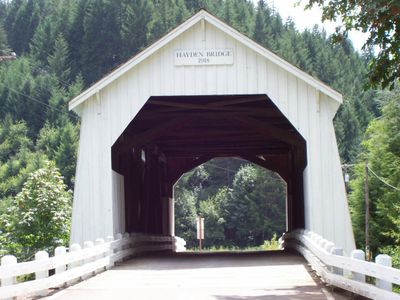
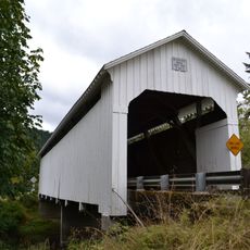
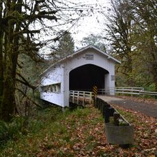
Hayden Bridge, Historic covered bridge on Alsea River, Oregon, United States.

Hayden Bridge is a historic wooden crossing that spans the Alsea River using a Howe truss frame with a protective roof running its full length. The structure features wooden planks for its roadway and demonstrates the classic building style of covered bridges from the early 20th century.

The bridge was built in 1918 and stands among the seven remaining covered bridges in Oregon constructed before 1920. It received recognition on the National Register in 1979, marking its importance as a surviving example of early engineering in the region.

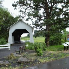
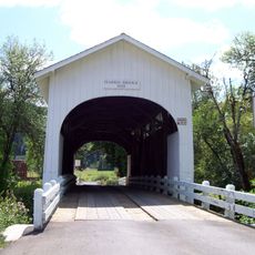
The bridge stands alongside two other historic wooden crossings in the county, showing how rural communities once designed their river passages. Visitors can see how the covered construction with its protective roof and wooden floor reflected the practical building methods of that time.

The crossing is accessible by a rural road and visits work best during the drier months. Visitors should be aware that the structure currently serves vehicles, though future plans for conversion to pedestrian-only use are in development.

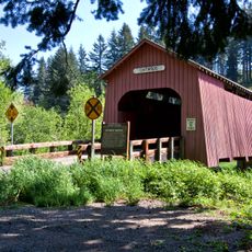
Though this structure dates to the early 20th century, its upkeep requires ongoing investment to maintain the original materials and distinctive design for future generations. This balance between historical authenticity and modern preservation needs makes it a telling example of the challenges in caring for aging infrastructure heritage.

Location: Benton County

GPS coordinates: 44.38310,-123.63100

Latest update: December 14, 2025 18:01

Photos
Around this place
Reser Stadium
United States of America

Reser Stadium

34 km
Marys Peak
United States of America

Marys Peak

14.9 km
Gill Coliseum
United States of America

Gill Coliseum

34.2 km
Memorial Union
United States of America

Memorial Union

34.5 km
William L. Finley National Wildlife Refuge
United States of America

William L. Finley National Wildlife Refuge

24.7 km
Drift Creek Wilderness
United States of America

Drift Creek Wilderness

25.2 km
Dixon Recreation Center
United States of America

Dixon Recreation Center

34.4 km
Irish Bend Covered Bridge
United States of America

Irish Bend Covered Bridge

33.2 km
Oregon State University Radiation Center
United States of America

Oregon State University Radiation Center

33.9 km
Alderwood State Wayside
United States of America

Alderwood State Wayside

30.3 km
Bell Field
United States of America

Bell Field

34.4 km
Ellmaker State Wayside
United States of America

Ellmaker State Wayside

25.8 km
Washburne State Wayside
United States of America

Washburne State Wayside

32.8 km
W. B. Nelson State Recreation Site
United States of America

W. B. Nelson State Recreation Site

32.4 km
United States of America

LaSells Stewart Center

34.1 km
Willamette Floodplain
United States of America

Willamette Floodplain

26.6 km
Lake Creek Bridge
United States of America

Lake Creek Bridge

31.2 km
Harris Bridge
United States of America

Harris Bridge

25.8 km
North Fork of the Yachats Bridge
United States of America

North Fork of the Yachats Bridge

28.2 km
Chitwood Bridge
United States of America

Chitwood Bridge

33.6 km
Deadwood Creek Bridge
United States of America

Deadwood Creek Bridge

27.6 km
Fisher School Bridge
United States of America

Fisher School Bridge

19.6 km
Monroe State Bank Building
United States of America

Monroe State Bank Building

27.7 km
John Bexell House
United States of America

John Bexell House

34.5 km
John Fiechter House
United States of America

John Fiechter House

26.4 km
Charles King House
United States of America

Charles King House

25.8 km
J. Leo Fairbanks House
United States of America

J. Leo Fairbanks House

34.4 km
George W. Bethers House
United States of America

George W. Bethers House

27 km
Show the full map
Reviews

Visited this place? Tap the stars to rate it and share your experience / photos with the community! Try now! You can cancel it anytime.

« Hayden Bridge - Historic covered bridge on Alsea River, Oregon, United States » is provided by Around Us (aroundus.com). Images and texts are derived from Wikimedia project under a Creative Commons license. You are allowed to copy, distribute, and modify copies of this page, under the conditions set by the license, as long as this note is clearly visible.

Discover hidden gems everywhere you go!

From secret cafés to breathtaking viewpoints, skip the crowded tourist spots and find places that match your style. Our app makes it easy with voice search, smart filtering, route optimization, and insider tips from travelers worldwide. Download now for the complete mobile experience.

Around Us App Screenshot

A unique approach to discovering new places

Le Figaro

All the places worth exploring

France Info

A tailor-made excursion in just a few clicks

20 Minutes