Enable Location

We need your location to show you interesting places around you

Discover nearby places

Find interesting locations and hidden gems around you

Precise directions

Get accurate directions and distances to places

Your location is never shared with other users. It's only used when you tap the location button.

Lake Creek Bridge

Log in to your account

Start exploring — it's free

Trusted by 61,878 travelers worldwide

Continue with Google
Continue with Apple
or

We will send you a code to connect

By continuing, you accept our Terms and Conditions and our Privacy Policy

Check your inbox

We've sent a pincode in your inbox. Please enter the code below.

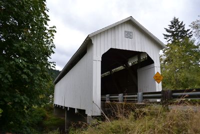
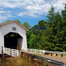
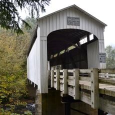
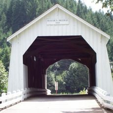
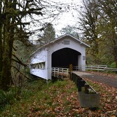
Lake Creek Bridge, Covered road bridge in Lane County, Oregon, United States.

Lake Creek Bridge is a 105-foot wooden bridge spanning Lake Creek, built with a Howe truss frame and featuring rectangular portal entrances at both ends. Narrow windows run along the roof eaves, creating the characteristic look of this covered bridge style.

This structure was built in 1928 to connect communities separated by Lake Creek. In 1979, it received a listing on the National Register of Historic Places, recognizing its importance as a historical landmark.

This bridge shows how early 20th-century engineers skillfully used wood from local forests to create safe crossings for nearby communities. The construction reflects the craftsmanship and practical knowledge that people relied on during that era.

Access is generally good, though the bridge is relatively narrow and not designed for modern heavy vehicles. Visit during dry conditions, as wet weather can make the wooden surfaces slippery and unsafe.

A major renovation in 1984 added reinforced concrete supports and new flooring while keeping the structure's original appearance intact. This restoration work demonstrates how old wooden bridges can be strengthened for modern use without losing their historical character.

The community of curious travelers

AroundUs brings together thousands of curated places, local tips, and hidden gems, enriched daily by 60,000 contributors worldwide.

Start exploring
Location
GPS coordinates
44.10440,-123.67400
Latest update
December 14, 2025 17:41
Around this place
Heceta Head Light
United States of America

Heceta Head Light

36.5 km
Siuslaw National Forest
United States of America

Siuslaw National Forest

27.7 km
Fern Ridge Reservoir
United States of America

Fern Ridge Reservoir

30.1 km
Darlingtonia State Natural Site
United States of America

Darlingtonia State Natural Site

34.4 km
Cummins Creek Wilderness
United States of America

Cummins Creek Wilderness

33.6 km
Rock Creek Wilderness
United States of America

Rock Creek Wilderness

31.7 km
Carl G. Washburne Memorial State Park
United States of America

Carl G. Washburne Memorial State Park

35.9 km
Cape Creek Bridge
United States of America

Cape Creek Bridge

36 km
Heceta Head Lighthouse
United States of America

Heceta Head Lighthouse

35.3 km
Alderwood State Wayside
United States of America

Alderwood State Wayside

20.8 km
Oregon Air and Space Museum
United States of America

Oregon Air and Space Museum

36.9 km
Fern Ridge Wildlife Area
United States of America

Fern Ridge Wildlife Area

29.9 km
Muriel O. Ponsler Memorial State Scenic Viewpoint
United States of America

Muriel O. Ponsler Memorial State Scenic Viewpoint

36 km
Tokatee Klootchman State Natural Site
United States of America

Tokatee Klootchman State Natural Site

37.1 km
Stonefield Beach State Recreation Site
United States of America

Stonefield Beach State Recreation Site

37.5 km
Big Creek Bridge
United States of America

Big Creek Bridge

36 km
Ten Mile Creek Bridge
United States of America

Ten Mile Creek Bridge

37.3 km
Coyote Creek Bridge
United States of America

Coyote Creek Bridge

32.1 km
North Fork of the Yachats Bridge
United States of America

North Fork of the Yachats Bridge

32.9 km
Wildcat Creek Bridge
United States of America

Wildcat Creek Bridge

11.4 km
Hayden Bridge
United States of America

Hayden Bridge

31.2 km
Edwin E. Benedict House
United States of America

Edwin E. Benedict House

34.5 km
Deadwood Creek Bridge
United States of America

Deadwood Creek Bridge

5.6 km
Fisher School Bridge
United States of America

Fisher School Bridge

24.7 km
Beaver Creek Falls
United States of America

Beaver Creek Falls

25.1 km
Charles C. Fitch Farmstead
United States of America

Charles C. Fitch Farmstead

32.5 km
Siuslaw River Bridge
United States of America

Siuslaw River Bridge

16.8 km
Sweet Creek Falls
United States of America

Sweet Creek Falls

25.4 km
Show the full map
« Lake Creek Bridge - Covered road bridge in Lane County, Oregon, United States » is provided by Around Us (aroundus.com). Images and texts are derived from Wikimedia project under a Creative Commons license. You are allowed to copy, distribute, and modify copies of this page, under the conditions set by the license, as long as this note is clearly visible.

Discover hidden gems everywhere you go!

From secret cafés to breathtaking viewpoints, skip the crowded tourist spots and find places that match your style. Our app makes it easy with voice search, smart filtering, route optimization, and insider tips from travelers worldwide. Download now for the complete mobile experience.

Around Us App Screenshot

A unique approach to discovering new places

Le Figaro

All the places worth exploring

France Info

A tailor-made excursion in just a few clicks

20 Minutes

Around Us
Travel Guide & Maps
Download

Send to your phone

QR Code
1

Open the camera app on your mobile.

2

Point at the QR code with your camera. A notification will appear.

3

Tap the notification to open the link.