Wildcat Creek Bridge

Log in to your account

AroundUs is a community-driven map of interesting places, built by curious explorers like you. It grows with every review, story, and photo you share.
Connect to save your favorite spots, contribute locations, and create personalized routes.
Continue with Google
Continue with Apple
Continue with X
Continue with Facebook
Continue with email
By continuing, you accept our Terms and Conditions and our Privacy Policy
Create an account
Add to collection
Map
Suggest a change
Share

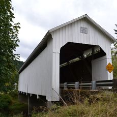
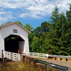
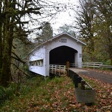
Wildcat Creek Bridge, Historic covered bridge in Lane County, Oregon, United States.

Wildcat Creek Bridge is a covered wooden bridge that crosses a small creek near its junction with the Siuslaw River in western Oregon. The structure has a single narrow roadway enclosed by wooden walls on both sides for protection and stability.

The bridge was built in 1925 as part of a historic road system connecting coastal and inland communities in the region. It served as a crucial passage for decades before modern highways made such routes less essential for transportation.

The bridge represents traditional Howe truss engineering methods, which were extensively used throughout Oregon's early transportation infrastructure development.

The bridge is located off Highway 126 and remains open to vehicle traffic with specific weight restrictions in place. The narrow passage requires careful driving and awareness of oncoming traffic when crossing.

Lane County minted around 325 commemorative coins featuring this bridge between 2005 and 2012 to fund maintenance work. These coins became collectible items among bridge enthusiasts and remain a notable example of creative preservation funding.

Location: Oregon

GPS coordinates: 44.00361,-123.65250

Latest update: December 14, 2025 18:03

Photos
Around this place
Heceta Head Light
United States of America

Heceta Head Light

40.8 km
Siuslaw National Forest
United States of America

Siuslaw National Forest

21.1 km
Jessie M. Honeyman Memorial State Park
United States of America

Jessie M. Honeyman Memorial State Park

37.3 km
Fern Ridge Reservoir
United States of America

Fern Ridge Reservoir

31.2 km
Darlingtonia State Natural Site
United States of America

Darlingtonia State Natural Site

35.8 km
King Estate Winery
United States of America

King Estate Winery

37.3 km
Siuslaw River Bridge
United States of America

Siuslaw River Bridge

36.8 km
Rock Creek Wilderness
United States of America

Rock Creek Wilderness

37.8 km
Cape Creek Bridge
United States of America

Cape Creek Bridge

40.3 km
Devil's Staircase Wilderness
United States of America

Devil's Staircase Wilderness

38.2 km
Heceta Head Lighthouse
United States of America

Heceta Head Lighthouse

39.7 km
Alderwood State Wayside
United States of America

Alderwood State Wayside

24.9 km
Oregon Air and Space Museum
United States of America

Oregon Air and Space Museum

37.3 km
Fern Ridge Wildlife Area
United States of America

Fern Ridge Wildlife Area

31.1 km
Kalapuya High School
United States of America

Kalapuya High School

37.9 km
Lake Creek Bridge
United States of America

Lake Creek Bridge

11.4 km
Coyote Creek Bridge
United States of America

Coyote Creek Bridge

27 km
Edwin E. Benedict House
United States of America

Edwin E. Benedict House

33.3 km
Deadwood Creek Bridge
United States of America

Deadwood Creek Bridge

16.4 km
Fisher School Bridge
United States of America

Fisher School Bridge

35.4 km
Beaver Creek Falls
United States of America

Beaver Creek Falls

20.4 km
Charles C. Fitch Farmstead
United States of America

Charles C. Fitch Farmstead

29.9 km
John Sutherland House
United States of America

John Sutherland House

34.4 km
Eye of the Needle
United States of America

Eye of the Needle

37.5 km
Jessie M. Honeyman Memorial State Park Hexagonal Kitchen Shelter
United States of America

Jessie M. Honeyman Memorial State Park Hexagonal Kitchen Shelter

37.7 km
Jessie M. Honeyman Memorial State Park Historic District
United States of America

Jessie M. Honeyman Memorial State Park Historic District

37.7 km
Siuslaw River Bridge
United States of America

Siuslaw River Bridge

16.7 km
Sweet Creek Falls
United States of America

Sweet Creek Falls

21.1 km
Show the full map
Reviews

Visited this place? Tap the stars to rate it and share your experience / photos with the community! Try now! You can cancel it anytime.

« Wildcat Creek Bridge - Historic covered bridge in Lane County, Oregon, United States » is provided by Around Us (aroundus.com). Images and texts are derived from Wikimedia project under a Creative Commons license. You are allowed to copy, distribute, and modify copies of this page, under the conditions set by the license, as long as this note is clearly visible.

Discover hidden gems everywhere you go!

From secret cafés to breathtaking viewpoints, skip the crowded tourist spots and find places that match your style. Our app makes it easy with voice search, smart filtering, route optimization, and insider tips from travelers worldwide. Download now for the complete mobile experience.

Around Us App Screenshot

A unique approach to discovering new places

Le Figaro

All the places worth exploring

France Info

A tailor-made excursion in just a few clicks

20 Minutes