North Fork of the Yachats Bridge
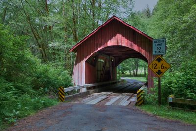
North Fork of the Yachats Bridge, Historic covered bridge near Yachats, United States
The North Fork of the Yachats Bridge is a covered bridge that spans across the Yachats River using a queen post truss design. The structure features characteristic ribbon openings beneath its roof, which are typical of the engineering approach used in early 20th century bridge construction.
Built in 1938 by bridge builder Otis Hamer, this structure marked the final project of his long career in bridge construction. The crossing was later added to the National Register of Historic Places, documenting the transportation infrastructure of early 20th century Oregon.
The bridge earned its place on the National Register of Historic Places in 1979, representing the engineering methods and transportation needs of early 20th century Oregon.
The structure sits about nine miles northeast of Yachats on North Fork Road and has a weight limit of ten tons for vehicles crossing. A vehicle turnaround area is provided at the location.
This crossing is one of only two covered bridges in Lincoln County that still handles vehicle traffic today. Its survival as a working bridge makes it a rare example of this building style in the region.
Location: Yachats
Inception: 1938
GPS coordinates: 44.30997,-123.96969
Latest update: December 14, 2025 18:05
Heceta Head Light
23 km
Oregon Coast Trail
12.5 km
Devils Churn
11.6 km
Alsea Bay Bridge
15.8 km
Drift Creek Wilderness
17.4 km
Cleft of the Rock Light
11.4 km
Cummins Creek Wilderness
8.7 km
Rock Creek Wilderness
16 km
Carl G. Washburne Memorial State Park
20.6 km
Cape Creek Bridge
23.1 km
Driftwood Beach State Recreation Site
19.2 km
Heceta Head Lighthouse
22.6 km
Beachside State Recreation Site
12.4 km
Neptune State Scenic Viewpoint
12.3 km
Seal Rock State Recreation Site
22.7 km
Alsea Bay Historic Interpretive Center
15.3 km
Yachats State Recreation Area
11.1 km
Muriel O. Ponsler Memorial State Scenic Viewpoint
19.4 km
Smelt Sands State Recreation Site
10.9 km
Yachats Ocean Road State Natural Site
10.8 km
Stonefield Beach State Recreation Site
14.8 km
Tokatee Klootchman State Natural Site
16.2 km
W. B. Nelson State Recreation Site
12.8 km
Big Creek Bridge
19 km
Governor Patterson Memorial State Recreation Site
14.8 km
Ten Mile Creek Bridge
14.7 km
Fisher School Bridge
10.4 km
Thor's Well
12 kmVisited this place? Tap the stars to rate it and share your experience / photos with the community! Try now! You can cancel it anytime.
Discover hidden gems everywhere you go!
From secret cafés to breathtaking viewpoints, skip the crowded tourist spots and find places that match your style. Our app makes it easy with voice search, smart filtering, route optimization, and insider tips from travelers worldwide. Download now for the complete mobile experience.
A unique approach to discovering new places❞
— Le Figaro
All the places worth exploring❞
— France Info
A tailor-made excursion in just a few clicks❞
— 20 Minutes