Enable Location

We need your location to show you interesting places around you

Discover nearby places

Find interesting locations and hidden gems around you

Precise directions

Get accurate directions and distances to places

Your location is never shared with other users. It's only used when you tap the location button.

W. B. Nelson State Recreation Site

Log in to your account

Start exploring — it's free

Trusted by 61,867 travelers worldwide

Continue with Google
Continue with Apple
or

We will send you a code to connect

By continuing, you accept our Terms and Conditions and our Privacy Policy

Check your inbox

We've sent a pincode in your inbox. Please enter the code below.

W. B. Nelson State Recreation Site

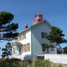
W. B. Nelson State Recreation Site, Public recreation site in Waldport, Oregon, United States

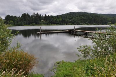
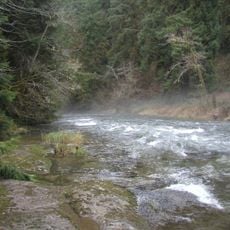
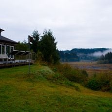
The W. B. Nelson State Recreation Site is a day-use area built around a freshwater lake surrounded by wetlands along the Alsea River. The lake features a fishing dock and is bordered by marsh vegetation and shallow banks that blend into the surrounding natural landscape.

The site became part of Oregon's state park system in 1959 through a donation from W. B. Nelson, who wanted to preserve the natural landscape. This gift secured protection for the lake and surrounding wetlands for public use.

The site draws local fishing enthusiasts who gather to share knowledge about bass and trout techniques. You will see anglers at the dock discussing their catches and comparing notes throughout the day.

The site offers day-use access with picnic areas and accessible paths suitable for visitors of all abilities. The paths are easy to walk during daytime hours, and facilities are straightforward to use without advance planning needed.

The wetlands serve as a major stopping point for waterfowl migration, with numerous species resting here during their seasonal journeys. Many visitors bring binoculars to watch the various duck, heron, and diving bird species that gather in the marshes.

The community of curious travelers

AroundUs brings together thousands of curated places, local tips, and hidden gems, enriched daily by 60,000 contributors worldwide.

Start exploring
Location
GPS coordinates
44.41510,-124.03600
Latest update
December 14, 2025 12:27
Around this place
Oregon Coast Aquarium
United States of America

Oregon Coast Aquarium

22.6 km
Yaquina Bay Bridge
United States of America

Yaquina Bay Bridge

23.2 km
Devils Churn
United States of America

Devils Churn

15.7 km
South Beach State Park
United States of America

South Beach State Park

21.1 km
Yaquina Bay Light
United States of America

Yaquina Bay Light

23.4 km
Alsea Bay Bridge
United States of America

Alsea Bay Bridge

3.3 km
Drift Creek Wilderness
United States of America

Drift Creek Wilderness

10.1 km
Cleft of the Rock Light
United States of America

Cleft of the Rock Light

15.1 km
Cummins Creek Wilderness
United States of America

Cummins Creek Wilderness

18.2 km
Driftwood Beach State Recreation Site
United States of America

Driftwood Beach State Recreation Site

6.4 km
Beachside State Recreation Site
United States of America

Beachside State Recreation Site

5.6 km
Yaquina Bay State Recreation Site
United States of America

Yaquina Bay State Recreation Site

23.3 km
Neptune State Scenic Viewpoint
United States of America

Neptune State Scenic Viewpoint

18.1 km
Seal Rock State Recreation Site
United States of America

Seal Rock State Recreation Site

9.9 km
Alsea Bay Historic Interpretive Center
United States of America

Alsea Bay Historic Interpretive Center

2.9 km
Yachats State Recreation Area
United States of America

Yachats State Recreation Area

12.9 km
Ona Beach State Park
United States of America

Ona Beach State Park

11.9 km
Lost Creek State Recreation Site
United States of America

Lost Creek State Recreation Site

14.8 km
Smelt Sands State Recreation Site
United States of America

Smelt Sands State Recreation Site

11.8 km
Beaver Creek State Natural Area
United States of America

Beaver Creek State Natural Area

11.1 km
Yachats Ocean Road State Natural Site
United States of America

Yachats Ocean Road State Natural Site

13.3 km
Stonefield Beach State Recreation Site
United States of America

Stonefield Beach State Recreation Site

22 km
Governor Patterson Memorial State Recreation Site
United States of America

Governor Patterson Memorial State Recreation Site

3.9 km
Ten Mile Creek Bridge
United States of America

Ten Mile Creek Bridge

22.1 km
North Fork of the Yachats Bridge
United States of America

North Fork of the Yachats Bridge

12.8 km
South Jetty
United States of America

South Jetty

22.5 km
Fisher School Bridge
United States of America

Fisher School Bridge

20.7 km
Thor's Well
United States of America

Thor's Well

16.4 km
Show the full map
« W. B. Nelson State Recreation Site - Public recreation site in Waldport, Oregon, United States » is provided by Around Us (aroundus.com). Images and texts are derived from Wikimedia project under a Creative Commons license. You are allowed to copy, distribute, and modify copies of this page, under the conditions set by the license, as long as this note is clearly visible.

Discover hidden gems everywhere you go!

From secret cafés to breathtaking viewpoints, skip the crowded tourist spots and find places that match your style. Our app makes it easy with voice search, smart filtering, route optimization, and insider tips from travelers worldwide. Download now for the complete mobile experience.

Around Us App Screenshot

A unique approach to discovering new places

Le Figaro

All the places worth exploring

France Info

A tailor-made excursion in just a few clicks

20 Minutes

Around Us
Travel Guide & Maps
Download

Send to your phone

QR Code
1

Open the camera app on your mobile.

2

Point at the QR code with your camera. A notification will appear.

3

Tap the notification to open the link.