Enable Location

We need your location to show you interesting places around you

Discover nearby places

Find interesting locations and hidden gems around you

Precise directions

Get accurate directions and distances to places

Your location is never shared with other users. It's only used when you tap the location button.

Big Creek Bridge

Log in to your account

Start exploring — it's free

Trusted by 61,869 travelers worldwide

Continue with Google
Continue with Apple
or

We will send you a code to connect

By continuing, you accept our Terms and Conditions and our Privacy Policy

Check your inbox

We've sent a pincode in your inbox. Please enter the code below.

Big Creek Bridge, Road bridge in Lane County, United States.

Description

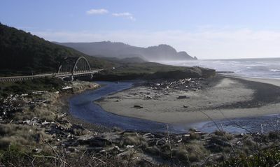
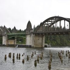
Big Creek Bridge is a road bridge that crosses Big Creek Canyon on US Route 101 using a tied-arch design to span the ravine. The structure has two main arches that support the roadway above the canyon floor.

History

Built in 1931, this bridge was part of the Oregon Coast Highway project that connected California to Washington. It represents the engineering approach of that era for highway construction across difficult terrain.

Culture

The bridge earned recognition in the National Register of Historic Places for its engineering excellence and contribution to the Pacific Northwest transportation network.

Practical

The bridge accommodates two lanes of traffic and is about 24 feet (7 meters) wide, making passage straightforward for vehicles. It sits roughly 65 feet (20 meters) above the canyon floor, providing a safe crossing height for the roadway.

Did you know?

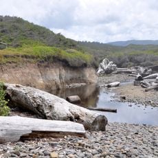
Construction crews used an innovative approach by hand-transporting tens of thousands of cement sacks up the canyon using wooden platforms and rope systems. This labor-intensive method shows how builders worked before modern machinery became standard in remote bridge projects.

Location
Architects
Conde Balcom McCullough
GPS coordinates
44.17444,-124.11417
Latest update
December 14, 2025 12:28

AroundUs brings together thousands of curated places, local tips, and hidden gems, enriched daily by 60,000 contributors worldwide. Discover all places nearby (Lane County).

Around this place
Heceta Head Light
United States of America

Heceta Head Light

4.3 km
Devils Churn
United States of America

Devils Churn

12.2 km
Darlingtonia State Natural Site
United States of America

Darlingtonia State Natural Site

14.4 km
Siuslaw River Bridge
United States of America

Siuslaw River Bridge

23.4 km
Cleft of the Rock Light
United States of America

Cleft of the Rock Light

12.9 km
Cummins Creek Wilderness
United States of America

Cummins Creek Wilderness

10.3 km
Rock Creek Wilderness
United States of America

Rock Creek Wilderness

4.7 km
Carl G. Washburne Memorial State Park
United States of America

Carl G. Washburne Memorial State Park

1.8 km
Cape Creek Bridge
United States of America

Cape Creek Bridge

4.6 km
Heceta Head Lighthouse
United States of America

Heceta Head Lighthouse

4.4 km
Beachside State Recreation Site
United States of America

Beachside State Recreation Site

23.1 km
Neptune State Scenic Viewpoint
United States of America

Neptune State Scenic Viewpoint

9.7 km
Yachats State Recreation Area
United States of America

Yachats State Recreation Area

15.2 km
Muriel O. Ponsler Memorial State Scenic Viewpoint
United States of America

Muriel O. Ponsler Memorial State Scenic Viewpoint

422 m
Smelt Sands State Recreation Site
United States of America

Smelt Sands State Recreation Site

16.4 km
Yachats Ocean Road State Natural Site
United States of America

Yachats Ocean Road State Natural Site

14.7 km
Stonefield Beach State Recreation Site
United States of America

Stonefield Beach State Recreation Site

5.6 km
Tokatee Klootchman State Natural Site
United States of America

Tokatee Klootchman State Natural Site

3.8 km
Governor Patterson Memorial State Recreation Site
United States of America

Governor Patterson Memorial State Recreation Site

26.8 km
Ten Mile Creek Bridge
United States of America

Ten Mile Creek Bridge

5.5 km
North Fork of the Yachats Bridge
United States of America

North Fork of the Yachats Bridge

19 km
Edwin E. Benedict House
United States of America

Edwin E. Benedict House

22.5 km
Fisher School Bridge
United States of America

Fisher School Bridge

25.4 km
Thor's Well
United States of America

Thor's Well

11.6 km
Cape Perpetua Shelter and Parapet
United States of America

Cape Perpetua Shelter and Parapet

12.6 km
Jessie M. Honeyman Memorial State Park Hexagonal Kitchen Shelter
United States of America

Jessie M. Honeyman Memorial State Park Hexagonal Kitchen Shelter

27 km
Jessie M. Honeyman Memorial State Park Historic District
United States of America

Jessie M. Honeyman Memorial State Park Historic District

27.1 km
Siuslaw River Bridge
United States of America

Siuslaw River Bridge

25.9 km
Show the full map
« Big Creek Bridge - Road bridge in Lane County, United States » is provided by Around Us (aroundus.com). Images and texts are derived from Wikimedia project under a Creative Commons license. You are allowed to copy, distribute, and modify copies of this page, under the conditions set by the license, as long as this note is clearly visible.

Discover hidden gems everywhere you go!

From secret cafés to breathtaking viewpoints, skip the crowded tourist spots and find places that match your style. Our app makes it easy with voice search, smart filtering, route optimization, and insider tips from travelers worldwide. Download now for the complete mobile experience.

Around Us App Screenshot

A unique approach to discovering new places

Le Figaro

All the places worth exploring

France Info

A tailor-made excursion in just a few clicks

20 Minutes

Around Us
Travel Guide & Maps
Download

Send to your phone

QR Code
1

Open the camera app on your mobile.

2

Point at the QR code with your camera. A notification will appear.

3

Tap the notification to open the link.