Chitwood Bridge

Log in to your account

AroundUs is a community-driven map of interesting places, built by curious explorers like you. It grows with every review, story, and photo you share.
Connect to save your favorite spots, contribute locations, and create personalized routes.
Continue with Google
Continue with Apple
Continue with X
Continue with Facebook
Continue with email
By continuing, you accept our Terms and Conditions and our Privacy Policy
Create an account
Add to collection
Map
Suggest a change
Share

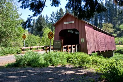
Chitwood Bridge, Covered bridge in Lincoln County, Oregon, US.

Chitwood Bridge is a wooden covered bridge that spans the Yaquina River in Lincoln County. It displays traditional Howe truss construction with wooden protective covering that shields the entire structure.

The structure was built in 1926 by Lincoln County authorities when wooden bridges like this were still commonly constructed. It was added to the National Register of Historic Places in 1979, marking recognition of its historical value.

The bridge carries the name of Joshua Chitwood, an early settler whose legacy tied to this rural area. The name reflects the local history and the people who helped shape the region.

The bridge sits near U.S. Route 20 and is readily accessible to visitors exploring this area. It underwent major restoration in 1984 to stabilize and preserve it for future generations.

This bridge was once scheduled for demolition but was saved through local advocacy and restoration efforts. It stands today as a rare surviving example of this construction style from Oregon's earlier era.

Location: Lincoln County

GPS coordinates: 44.65422,-123.81775

Latest update: December 14, 2025 18:04

Photos
Around this place
Devils Punch Bowl State Natural Area
United States of America

Devils Punch Bowl State Natural Area

22.2 km
Oregon Coast Aquarium
United States of America

Oregon Coast Aquarium

18.6 km
Yaquina Head Light
United States of America

Yaquina Head Light

20.8 km
Yaquina Bay Bridge
United States of America

Yaquina Bay Bridge

19.3 km
Beverly Beach State Park
United States of America

Beverly Beach State Park

20.8 km
Devils Punchbowl State Natural Area
United States of America

Devils Punchbowl State Natural Area

22 km
South Beach State Park
United States of America

South Beach State Park

20.3 km
Yaquina Bay Light
United States of America

Yaquina Bay Light

19.7 km
United States of America

Jumpoff Joe

19.4 km
Drift Creek Wilderness
United States of America

Drift Creek Wilderness

23 km
Agate Beach State Recreation Site
United States of America

Agate Beach State Recreation Site

19 km
Devil's Punchbowl
United States of America

Devil's Punchbowl

22.1 km
Yaquina Bay State Recreation Site
United States of America

Yaquina Bay State Recreation Site

19.6 km
Otter Crest State Scenic Viewpoint
United States of America

Otter Crest State Scenic Viewpoint

23 km
Rocky Creek State Scenic Viewpoint
United States of America

Rocky Creek State Scenic Viewpoint

24.6 km
Ona Beach State Park
United States of America

Ona Beach State Park

25.3 km
Lost Creek State Recreation Site
United States of America

Lost Creek State Recreation Site

23.6 km
Beaver Creek State Natural Area
United States of America

Beaver Creek State Natural Area

24 km
Ellmaker State Wayside
United States of America

Ellmaker State Wayside

15.4 km
Oregon Undersea Gardens
United States of America

Oregon Undersea Gardens

18.7 km
Rocky Creek Bridge
United States of America

Rocky Creek Bridge

24.4 km
South Jetty
United States of America

South Jetty

19.5 km
Charles and Theresa Roper House
United States of America

Charles and Theresa Roper House

19.2 km
St. John's Episcopal Church
United States of America

St. John's Episcopal Church

10 km
Whale Research EcoExcursions
United States of America

Whale Research EcoExcursions

25.8 km
Nye Beach
United States of America

Nye Beach

19.4 km
Newport Visual Arts Center
United States of America

Newport Visual Arts Center

19.4 km
Nye Beach
United States of America

Nye Beach

19.4 km
Show the full map
Reviews

Visited this place? Tap the stars to rate it and share your experience / photos with the community! Try now! You can cancel it anytime.

« Chitwood Bridge - Covered bridge in Lincoln County, Oregon, US » is provided by Around Us (aroundus.com). Images and texts are derived from Wikimedia project under a Creative Commons license. You are allowed to copy, distribute, and modify copies of this page, under the conditions set by the license, as long as this note is clearly visible.

Discover hidden gems everywhere you go!

From secret cafés to breathtaking viewpoints, skip the crowded tourist spots and find places that match your style. Our app makes it easy with voice search, smart filtering, route optimization, and insider tips from travelers worldwide. Download now for the complete mobile experience.

Around Us App Screenshot

A unique approach to discovering new places

Le Figaro

All the places worth exploring

France Info

A tailor-made excursion in just a few clicks

20 Minutes