Enable Location

We need your location to show you interesting places around you

Discover nearby places

Find interesting locations and hidden gems around you

Precise directions

Get accurate directions and distances to places

Your location is never shared with other users. It's only used when you tap the location button.

Devil's Punchbowl

Log in to your account

Start exploring — it's free

Trusted by 61,880 travelers worldwide

Continue with Google
Continue with Apple
or

We will send you a code to connect

By continuing, you accept our Terms and Conditions and our Privacy Policy

Check your inbox

We've sent a pincode in your inbox. Please enter the code below.

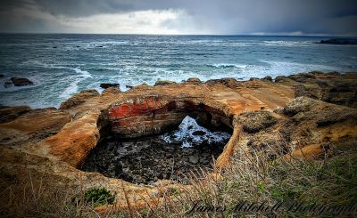
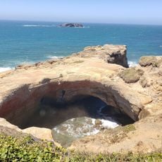
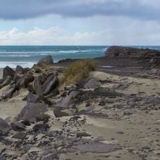
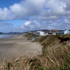
Devil's Punchbowl, Natural rock formation in Lincoln County, Oregon.

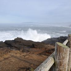
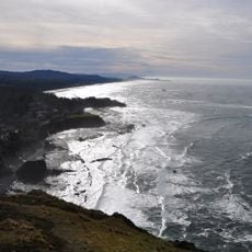
Devil's Punchbowl is a coastal rock formation in Oregon that creates a circular basin where ocean waves surge through cave openings. These channels direct water into the enclosed space, causing dramatic swirling and churning during high tides and rough seas.

The site became a state natural area in 1929 through land donations by F.W. and C.P. Leadbetter. Subsequent acquisitions expanded the protected area until 1971.

Native American tribes from the Pacific Northwest considered this geological structure a sacred place for ceremonial gatherings and spiritual connections.

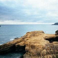
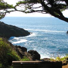
The site has designated parking and well-maintained paths leading to multiple viewpoints of the rock formation. Visit during high tide or stormy weather to see the most active water movements through the basin.

During winter storms, water erupts violently from the cave openings, creating towering spray displays that shoot high above the cliffs. These dramatic jets are best witnessed from the observation points during powerful swells.

The community of curious travelers

AroundUs brings together thousands of curated places, local tips, and hidden gems, enriched daily by 60,000 contributors worldwide.

Start exploring
Location
Address
Devils Punchbowl State Natural Area, 122 1st St, Otter Rock, OR 97369, USA
Opening Hours
Dimanche: 00:00 -
GPS coordinates
44.74704,-124.06523
Latest update
December 8, 2025 21:07
Around this place
Devils Punch Bowl State Natural Area
United States of America

Devils Punch Bowl State Natural Area

154 m
Oregon Coast Aquarium
United States of America

Oregon Coast Aquarium

14.5 km
Yaquina Head Light
United States of America

Yaquina Head Light

7.9 km
Yaquina Bay Bridge
United States of America

Yaquina Bay Bridge

13.9 km
Beverly Beach State Park
United States of America

Beverly Beach State Park

2 km
Whale Watching Center
United States of America

Whale Watching Center

7 km
Devils Punchbowl State Natural Area
United States of America

Devils Punchbowl State Natural Area

138 m
South Beach State Park
United States of America

South Beach State Park

15.9 km
Yaquina Bay Light
United States of America

Yaquina Bay Light

13.7 km
United States of America

Jumpoff Joe

11.3 km
Boiler Bay State Scenic Viewpoint
United States of America

Boiler Bay State Scenic Viewpoint

9 km
Siletz Bay National Wildlife Refuge
United States of America

Siletz Bay National Wildlife Refuge

17.8 km
Agate Beach State Recreation Site
United States of America

Agate Beach State Recreation Site

9.8 km
Yaquina Bay State Recreation Site
United States of America

Yaquina Bay State Recreation Site

13.7 km
Otter Crest State Scenic Viewpoint
United States of America

Otter Crest State Scenic Viewpoint

1.5 km
Rocky Creek State Scenic Viewpoint
United States of America

Rocky Creek State Scenic Viewpoint

3.9 km
Fogarty Creek State Recreation Area
United States of America

Fogarty Creek State Recreation Area

10.7 km
Gleneden Beach State Recreation Site
United States of America

Gleneden Beach State Recreation Site

14.6 km
Depoe Bay Bridge
United States of America

Depoe Bay Bridge

7 km
Oregon Undersea Gardens
United States of America

Oregon Undersea Gardens

13 km
Rocky Creek Bridge
United States of America

Rocky Creek Bridge

3.5 km
South Jetty
United States of America

South Jetty

14.5 km
Charles and Theresa Roper House
United States of America

Charles and Theresa Roper House

12.7 km
St. John's Episcopal Church
United States of America

St. John's Episcopal Church

17.5 km
Whale Research EcoExcursions
United States of America

Whale Research EcoExcursions

6.9 km
Nye Beach
United States of America

Nye Beach

11.6 km
Newport Visual Arts Center
United States of America

Newport Visual Arts Center

12.1 km
Nye Beach
United States of America

Nye Beach

11.7 km
Show the full map
« Devil's Punchbowl - Natural rock formation in Lincoln County, Oregon » is provided by Around Us (aroundus.com). Images and texts are derived from Wikimedia project under a Creative Commons license. You are allowed to copy, distribute, and modify copies of this page, under the conditions set by the license, as long as this note is clearly visible.

Discover hidden gems everywhere you go!

From secret cafés to breathtaking viewpoints, skip the crowded tourist spots and find places that match your style. Our app makes it easy with voice search, smart filtering, route optimization, and insider tips from travelers worldwide. Download now for the complete mobile experience.

Around Us App Screenshot

A unique approach to discovering new places

Le Figaro

All the places worth exploring

France Info

A tailor-made excursion in just a few clicks

20 Minutes

Around Us
Travel Guide & Maps
Download

Send to your phone

QR Code
1

Open the camera app on your mobile.

2

Point at the QR code with your camera. A notification will appear.

3

Tap the notification to open the link.