Enable Location

We need your location to show you interesting places around you

Discover nearby places

Find interesting locations and hidden gems around you

Precise directions

Get accurate directions and distances to places

Your location is never shared with other users. It's only used when you tap the location button.

Tumalo State Park

Log in to your account

Start exploring — it's free

Trusted by 65,640 travelers worldwide

Continue with Google
Continue with Apple
or

We will send you a code to connect

By continuing, you accept our Terms and Conditions and our Privacy Policy

Check your inbox

We've sent a pincode in your inbox. Please enter the code below.

Tumalo State Park
Discussion Reviews 1 Photos
6.4k Popularity

Tumalo State Park, State park on Deschutes River, Deschutes County, Oregon

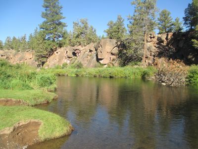
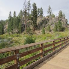
Tumalo State Park is an Oregon state park along the Deschutes River in Deschutes County. Reddish basalt cliffs line both sides of the river, and western juniper and ponderosa pine trees grow down to the water's edge, giving the park the feel of a dry mountain canyon.

The land became a state park in 1954, when Deschutes County transferred an initial parcel to the state of Oregon. A second addition in 1972 more than doubled the protected area, completing the park as it stands today.

The name Deschutes comes from the French phrase meaning 'of the falls', a reference to the waterfalls near where the river meets the Columbia River. Today, visitors use the river mostly for swimming and fishing, continuing a long tradition of gathering around the water.

The park has camping spots for tents and trailers, as well as yurt cabins for those who prefer a roof overhead. Facilities include solar-powered showers, restrooms, and laundry, making it easy to stay for several nights without leaving the grounds.

Great blue herons nest in the basalt cliffs along the river, while mountain chickadees and western meadowlarks are often spotted near the water. Visitors who arrive early in the morning are most likely to see the herons before they leave their nesting spots.

The community of curious travelers

AroundUs brings together thousands of curated places, local tips, and hidden gems, enriched daily by 60,000 contributors worldwide.

Start exploring
Location
Inception
1954
GPS coordinates
44.12710,-121.33200
Latest update
March 3, 2026 10:10
Around this place
The last Blockbuster
United States of America

The last Blockbuster

7 km
Pilot Butte
United States of America

Pilot Butte

8.4 km
Les Schwab Amphitheater
United States of America

Les Schwab Amphitheater

9 km
Mirror Pond
United States of America

Mirror Pond

7.4 km
Old St. Francis School
United States of America

Old St. Francis School

8 km
N. P. Smith Pioneer Hardware Store
United States of America

N. P. Smith Pioneer Hardware Store

7.7 km
Tower Theatre
United States of America

Tower Theatre

7.8 km
Thomas McCann House
United States of America

Thomas McCann House

7.9 km
O'Kane Building
United States of America

O'Kane Building

7.7 km
George Palmer and Dorothy Binney Putnam House
United States of America

George Palmer and Dorothy Binney Putnam House

7.8 km
Reid School
United States of America

Reid School

8.1 km
Old Bend High School
United States of America

Old Bend High School

8 km
Goodwillie–Allen House
United States of America

Goodwillie–Allen House

7.7 km
Sun Mountain Fun Center
United States of America

Sun Mountain Fun Center

5.3 km
Charles Boyd Homestead Group
United States of America

Charles Boyd Homestead Group

5.3 km
Deschutes Public Library Administration Building
United States of America

Deschutes Public Library Administration Building

8 km
Congress Apartments
United States of America

Congress Apartments

8 km
Rock O' the Range Bridge
United States of America

Rock O' the Range Bridge

3.8 km
Evan Andreas Sather House
United States of America

Evan Andreas Sather House

8 km
Old U.S. Post Office
United States of America

Old U.S. Post Office

7.8 km
B. A. and Ruth Stover House
United States of America

B. A. and Ruth Stover House

7.4 km
Robert D. Moore House
United States of America

Robert D. Moore House

7.8 km
Bend Whitewater Park
United States of America

Bend Whitewater Park

8.6 km
Emil and Ottilie Wienecke House
United States of America

Emil and Ottilie Wienecke House

7.3 km
Peter Byberg House
United States of America

Peter Byberg House

8.3 km
Simpson E. Jones House
United States of America

Simpson E. Jones House

8.2 km
Juniper Swim and Fitness
United States of America

Juniper Swim and Fitness

8.3 km
Deschutes River Trail
United States of America

Deschutes River Trail

3.5 km
Show the full map
Reviews
Share your experience

No review yet

Discussions
Start a discussion...

No discussion yet

« Tumalo State Park - State park on Deschutes River, Deschutes County, Oregon » is provided by Around Us (aroundus.com). Images and texts are derived from Wikimedia project under a Creative Commons license. You are allowed to copy, distribute, and modify copies of this page, under the conditions set by the license, as long as this note is clearly visible.

Discover hidden gems everywhere you go!

From secret cafés to breathtaking viewpoints, skip the crowded tourist spots and find places that match your style. Our app makes it easy with voice search, smart filtering, route optimization, and insider tips from travelers worldwide. Download now for the complete mobile experience.

Around Us App Screenshot

A unique approach to discovering new places

Le Figaro

All the places worth exploring

France Info

A tailor-made excursion in just a few clicks

20 Minutes

Around Us
Travel Guide & Maps
Download

Send to your phone

QR Code
1

Open the camera app on your mobile.

2

Point at the QR code with your camera. A notification will appear.

3

Tap the notification to open the link.