Chest opened
+${chestReward.xp} XP
Explorer
NOUVEAU ×${chestReward.collectible.quantity}
tapez pour fermer
Chest locked

Open chests in the app

Around Us is built for your phone — chests unlock when you walk, explore and capture nearby places.

Enable Location

We need your location to show you interesting places around you

Discover nearby places

Find interesting locations and hidden gems around you

Precise directions

Get accurate directions and distances to places

Your location is never shared with other users. It's only used when you tap the location button.

Log in to your account

Start exploring — it's free

Trusted by 72,890 travelers worldwide

Continue with Google
Continue with Apple
or

We will send you a code to connect

By continuing, you accept our Terms and Conditions and our Privacy Policy

Check your inbox

We've sent a pincode in your inbox. Please enter the code below.

Ash Island
Discussion Reviews Photo
1.9k Popularity

Ash Island, River island in Willamette River, Yamhill County, Oregon.

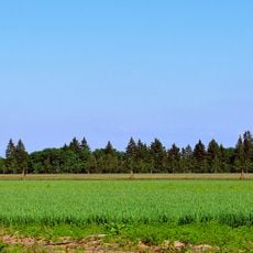
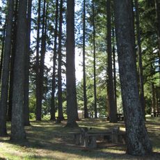
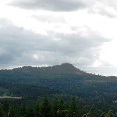
Ash Island is a river island in the Willamette River spanning about 137 acres with sandy fields and wooded shorelines along the water. The terrain includes both open grassland areas and forest sections that border the river channel.

A water level monitoring station operated by the National Oceanic and Atmospheric Administration was established on the island starting in 1950. This station has continuously tracked river water conditions since its installation on the site.

The island operates as active farmland where agricultural work continues throughout the year alongside natural habitats for native wildlife. Daily farming activities shape how the landscape looks and functions for both people and animals.

Reaching the island requires boat access from nearby river landings, as there is no bridge or road connection to the mainland. Visitors should plan to arrange transportation by water and respect any private property boundaries on the site.

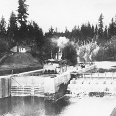
A wooden dam at the southern end of the channel creates distinct water flow patterns around the island that shape how the river moves past the site. This structure demonstrates how human engineering alters the natural currents and behavior of the waterway.

The community of curious travelers

AroundUs brings together thousands of curated places, local tips, and hidden gems, enriched daily by 60,000 contributors worldwide.

Start exploring
Location
GPS coordinates
45.27260,-122.98400
Latest update
December 21, 2025 16:05
Around this place
Evergreen Aviation & Space Museum
United States of America

Evergreen Aviation & Space Museum

14.6 km
French Prairie
United States of America

French Prairie

10 km
Bald Peak State Scenic Viewpoint
United States of America

Bald Peak State Scenic Viewpoint

14.7 km
Our Lady of Guadalupe Trappist Abbey
United States of America

Our Lady of Guadalupe Trappist Abbey

8.5 km
Hoover–Minthorn House
United States of America

Hoover–Minthorn House

3.2 km
St. Paul Roman Catholic Church
United States of America

St. Paul Roman Catholic Church

6.8 km
Sherwood Public Library
United States of America

Sherwood Public Library

14.7 km
Yamhill River lock and dam
United States of America

Yamhill River lock and dam

10.5 km
Evergreen Wings and Waves Waterpark
United States of America

Evergreen Wings and Waves Waterpark

15.1 km
Bald Peak
United States of America

Bald Peak

14.8 km
Palmer House
United States of America

Palmer House

9.6 km
Newberg Public Library
United States of America

Newberg Public Library

3.3 km
Pioneer Mothers Memorial Cabin Museum
United States of America

Pioneer Mothers Memorial Cabin Museum

6.8 km
First Baptist Church
United States of America

First Baptist Church

9.1 km
Free Methodist Church
United States of America

Free Methodist Church

9.4 km
Newell House Museum
United States of America

Newell House Museum

7.3 km
Minthorn Hall
United States of America

Minthorn Hall

3.7 km
Jesse Edwards House
United States of America

Jesse Edwards House

3 km
Evangelical United Brethren Church
United States of America

Evangelical United Brethren Church

9.4 km
Evangelical Church of Lafayette
United States of America

Evangelical Church of Lafayette

10.4 km
Paul Londershausen House
United States of America

Paul Londershausen House

9.2 km
John T. Hash House
United States of America

John T. Hash House

9.4 km
Baxter House
United States of America

Baxter House

9.3 km
Methodist Episcopal Parsonage
United States of America

Methodist Episcopal Parsonage

9.2 km
Dr. Stuart House
United States of America

Dr. Stuart House

8.9 km
Gottlieb Londershausen House
United States of America

Gottlieb Londershausen House

9.3 km
Cameo Theatre
United States of America

Cameo Theatre

3.1 km
99 W Drive-In
United States of America

99 W Drive-In

4.6 km
Show the full map
Reviews
Share your experience

No review yet

Discussions
Start a discussion...

No discussion yet

« Ash Island - River island in Willamette River, Yamhill County, Oregon » is provided by Around Us (aroundus.com). Images and texts are derived from Wikimedia project under a Creative Commons license. You are allowed to copy, distribute, and modify copies of this page, under the conditions set by the license, as long as this note is clearly visible.

Discover hidden gems everywhere you go!

From secret cafés to breathtaking viewpoints, skip the crowded tourist spots and find places that match your style. Our app makes it easy with voice search, smart filtering, route optimization, and insider tips from travelers worldwide. Download now for the complete mobile experience.

Around Us App Screenshot

A unique approach to discovering new places

Le Figaro

All the places worth exploring

France Info

A tailor-made excursion in just a few clicks

20 Minutes

Around Us
Travel Guide & Maps
Download

Send to your phone

QR Code
1

Open the camera app on your mobile.

2

Point at the QR code with your camera. A notification will appear.

3

Tap the notification to open the link.