Enable Location

We need your location to show you interesting places around you

Discover nearby places

Find interesting locations and hidden gems around you

Precise directions

Get accurate directions and distances to places

Your location is never shared with other users. It's only used when you tap the location button.

Damon Point State Park

Log in to your account

Start exploring — it's free

Trusted by 66,037 travelers worldwide

Continue with Google
Continue with Apple
or

We will send you a code to connect

By continuing, you accept our Terms and Conditions and our Privacy Policy

Check your inbox

We've sent a pincode in your inbox. Please enter the code below.

Damon Point State Park
Discussion Reviews 1 Photos
3.2k Popularity

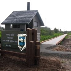
Damon Point State Park, State park at Ocean Shores Peninsula, United States.

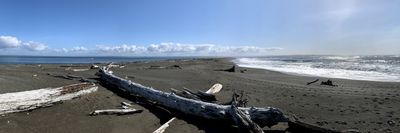
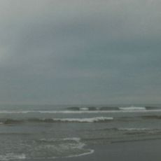
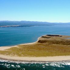
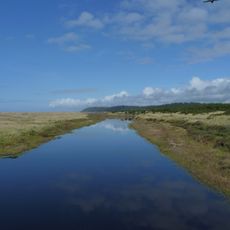
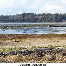
Damon Point State Park is a coastal reserve on a peninsula that juts into Grays Harbor along the Washington coast. A sandy trail runs along the shoreline, and on clear days both Mount Rainier and the Olympic Mountains are visible from the tip of the point.

The land was set aside as a public park to protect an area where coastal forces actively reshape the shoreline over time. Ocean currents and storms have continuously moved sand and sediment, making the peninsula one of the more geologically active spots on this part of the coast.

The park draws birders from across the region, as snowy plovers and bald eagles are regularly spotted along the shoreline. Many visitors arrive with binoculars and spend time scanning the beach and the water for rare sightings.

The park is open year-round, and a few picnic tables sit along the shore without any cover from the wind or rain. Coastal weather here can shift quickly, so bringing layers and rain gear is a good idea regardless of the forecast.

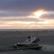
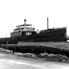
Beneath the sand lies the wreck of the S.S. Catala, a ship that ran aground during a winter storm in 1965 and was slowly buried by shifting sand. Depending on tides and storms, parts of the hull occasionally reappear at the surface, making each visit to the beach slightly different from the last.

The community of curious travelers

AroundUs brings together thousands of curated places, local tips, and hidden gems, enriched daily by 60,000 contributors worldwide.

Start exploring
Location
GPS coordinates
46.94480,-124.11600
Latest update
March 3, 2026 13:55
Around this place
Young Street Bridge
United States of America

Young Street Bridge

24 km
Grayland Beach State Park
United States of America

Grayland Beach State Park

17.5 km
Lake Sylvia State Park
United States of America

Lake Sylvia State Park

40.5 km
Twin Harbors State Park
United States of America

Twin Harbors State Park

9.8 km
Leadbetter Point State Park
United States of America

Leadbetter Point State Park

37 km
Grays Harbor Light
United States of America

Grays Harbor Light

6.3 km
Pacific Beach State Park
United States of America

Pacific Beach State Park

29.8 km
Westport Light State Park
United States of America

Westport Light State Park

5.8 km
Grays Harbor National Wildlife Refuge
United States of America

Grays Harbor National Wildlife Refuge

14.4 km
Bottle Beach State Park
United States of America

Bottle Beach State Park

8.6 km
Hoquiam's Castle
United States of America

Hoquiam's Castle

17.9 km
7th Street Theatre
United States of America

7th Street Theatre

17.9 km
Chow Chow Bridge
United States of America

Chow Chow Bridge

45.8 km
Quinault Cultural Center and Museum
United States of America

Quinault Cultural Center and Museum

46.1 km
Willapa Bay Light
United States of America

Willapa Bay Light

26.3 km
Joseph Lytle House
United States of America

Joseph Lytle House

17.7 km
Carnegie Library
United States of America

Carnegie Library

17.8 km
Sierra
United States of America

Sierra

24.2 km
Masonic Temple-Hoquiam
United States of America

Masonic Temple-Hoquiam

17.8 km
Raymond Theatre
United States of America

Raymond Theatre

41.2 km
Wishkah River Bridge
United States of America

Wishkah River Bridge

23.4 km
Riverside Avenue Bridge
United States of America

Riverside Avenue Bridge

18 km
Satsop River Bridges
United States of America

Satsop River Bridges

47.7 km
Chehalis River Bridge
United States of America

Chehalis River Bridge

23.5 km
International Mermaid Museum
United States of America

International Mermaid Museum

11.5 km
Olympic Stadium
United States of America

Olympic Stadium

19.9 km
Pacific County Courthouse
United States of America

Pacific County Courthouse

39.1 km
D & R Theatre
United States of America

D & R Theatre

23 km
Show the full map
Reviews
Share your experience

No review yet

Discussions
Start a discussion...

No discussion yet

« Damon Point State Park - State park at Ocean Shores Peninsula, United States » is provided by Around Us (aroundus.com). Images and texts are derived from Wikimedia project under a Creative Commons license. You are allowed to copy, distribute, and modify copies of this page, under the conditions set by the license, as long as this note is clearly visible.

Discover hidden gems everywhere you go!

From secret cafés to breathtaking viewpoints, skip the crowded tourist spots and find places that match your style. Our app makes it easy with voice search, smart filtering, route optimization, and insider tips from travelers worldwide. Download now for the complete mobile experience.

Around Us App Screenshot

A unique approach to discovering new places

Le Figaro

All the places worth exploring

France Info

A tailor-made excursion in just a few clicks

20 Minutes

Around Us
Travel Guide & Maps
Download

Send to your phone

QR Code
1

Open the camera app on your mobile.

2

Point at the QR code with your camera. A notification will appear.

3

Tap the notification to open the link.