Enable Location

We need your location to show you interesting places around you

Discover nearby places

Find interesting locations and hidden gems around you

Precise directions

Get accurate directions and distances to places

Your location is never shared with other users. It's only used when you tap the location button.

Eighteenmile Island

Log in to your account

Start exploring — it's free

Trusted by 64,890 travelers worldwide

Continue with Google
Continue with Apple
or

We will send you a code to connect

By continuing, you accept our Terms and Conditions and our Privacy Policy

Check your inbox

We've sent a pincode in your inbox. Please enter the code below.

Eighteenmile Island
Discussion Reviews 1 Photos
6.4k Popularity

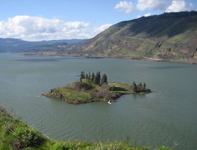
Eighteenmile Island, River island in Wasco County, Oregon.

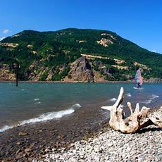
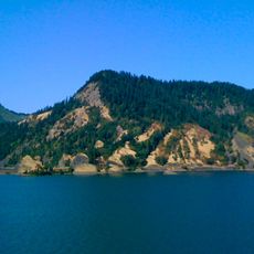
Eighteenmile Island is a river island in the Columbia River, located between the towns of Mosier and Hood River in Wasco County, Oregon. The island is covered with pine and willow trees growing over basalt rock formations, and a sandy beach runs along one side.

The Lewis and Clark Expedition noted this island during their journey across the continent in the early 1800s. Decades later, a man named Charles Reither, known locally as Chicken Charlie, made the island his home from 1915 to 1963.

Eighteenmile Island is one of the few spots along the Columbia River that remains privately owned and inhabited today. The single house on the island gives it a character unlike anything else along this stretch of river, where most land is public or undeveloped.

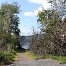
The island can only be reached by boat, as there is no bridge or public ferry connecting it to the shore. The property is privately owned and has a resident, so visitors should not attempt to land without permission.

The house on the island was built in the late 1960s and gets its electricity from a line running from the mainland, while drinking water comes from filtering the river directly. This makes it one of the very few permanently inhabited river islands in Oregon.

The community of curious travelers

AroundUs brings together thousands of curated places, local tips, and hidden gems, enriched daily by 60,000 contributors worldwide.

Start exploring
Location
GPS coordinates
45.68972,-121.42139
Latest update
March 3, 2026 10:11
Around this place
Columbia River Gorge National Scenic Area
United States of America

Columbia River Gorge National Scenic Area

17.2 km
Mount Hood Railroad
United States of America

Mount Hood Railroad

7.7 km
Western Antique Aeroplane & Automobile Museum
United States of America

Western Antique Aeroplane & Automobile Museum

9.4 km
Memaloose State Park
United States of America

Memaloose State Park

6.9 km
Mayer State Park
United States of America

Mayer State Park

11.9 km
Viento State Park
United States of America

Viento State Park

19.2 km
Koberg Beach State Recreation Site
United States of America

Koberg Beach State Recreation Site

2.8 km
Spring Creek Hatchery State Park
United States of America

Spring Creek Hatchery State Park

10.3 km
Seneca Fouts Memorial State Natural Area
United States of America

Seneca Fouts Memorial State Natural Area

15.4 km
Columbia Gorge Discovery Center
United States of America

Columbia Gorge Discovery Center

16.9 km
Butler Bank
United States of America

Butler Bank

7.4 km
Edward J. DeHart House
United States of America

Edward J. DeHart House

10 km
Simpson Copple House
United States of America

Simpson Copple House

7.8 km
Jefferson Mosier House
United States of America

Jefferson Mosier House

2.2 km
Cliff Lodge
United States of America

Cliff Lodge

9.7 km
Martin and Carrie Hill House
United States of America

Martin and Carrie Hill House

7.9 km
Orrin B. Hartley House
United States of America

Orrin B. Hartley House

8.1 km
Davidson–Childs House
United States of America

Davidson–Childs House

7.7 km
Hood River Bridge
United States of America

Hood River Bridge

6.5 km
Ernest S. and Clara C. Colby House
United States of America

Ernest S. and Clara C. Colby House

8.2 km
Roe–Parker House
United States of America

Roe–Parker House

7.5 km
Shaw–Dumble House
United States of America

Shaw–Dumble House

7.8 km
Robert and Mabel Loomis House
United States of America

Robert and Mabel Loomis House

8.1 km
Lester and Hazel Murphy House
United States of America

Lester and Hazel Murphy House

8 km
John C. Duckwall House
United States of America

John C. Duckwall House

7.8 km
Dog Creek Falls
United States of America

Dog Creek Falls

19.5 km
Chenoweth Creek Bridge
United States of America

Chenoweth Creek Bridge

17.2 km
Mill Creek Bridge
United States of America

Mill Creek Bridge

20.2 km
Show the full map
Reviews
Share your experience

No review yet

Discussions
Start a discussion...

No discussion yet

« Eighteenmile Island - River island in Wasco County, Oregon » is provided by Around Us (aroundus.com). Images and texts are derived from Wikimedia project under a Creative Commons license. You are allowed to copy, distribute, and modify copies of this page, under the conditions set by the license, as long as this note is clearly visible.

Discover hidden gems everywhere you go!

From secret cafés to breathtaking viewpoints, skip the crowded tourist spots and find places that match your style. Our app makes it easy with voice search, smart filtering, route optimization, and insider tips from travelers worldwide. Download now for the complete mobile experience.

Around Us App Screenshot

A unique approach to discovering new places

Le Figaro

All the places worth exploring

France Info

A tailor-made excursion in just a few clicks

20 Minutes

Around Us
Travel Guide & Maps
Download

Send to your phone

QR Code
1

Open the camera app on your mobile.

2

Point at the QR code with your camera. A notification will appear.

3

Tap the notification to open the link.