Enable Location

We need your location to show you interesting places around you

Discover nearby places

Find interesting locations and hidden gems around you

Precise directions

Get accurate directions and distances to places

Your location is never shared with other users. It's only used when you tap the location button.

Manette Bridge

Log in to your account

Start exploring — it's free

Trusted by 62,376 travelers worldwide

Continue with Google
Continue with Apple
or

We will send you a code to connect

By continuing, you accept our Terms and Conditions and our Privacy Policy

Check your inbox

We've sent a pincode in your inbox. Please enter the code below.

Manette Bridge

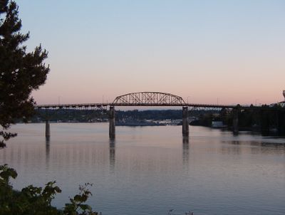
Manette Bridge, Road bridge across Port Washington Narrows in Bremerton, US.

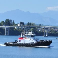
Manette Bridge is a steel truss bridge that crosses Port Washington Narrows and connects downtown Bremerton with the Manette district. The structure uses a series of support columns in the water and open framework above the roadway to allow ships to pass underneath.

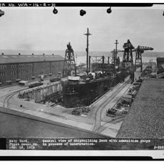
The bridge opened in 1930 following a major push by local communities to connect both sides of the waterway. Before this structure existed, ferry services were the only way for people to travel between the two shores.

The bridge connects two neighborhoods that were previously separated by water, and its opening brought these communities closer together in daily life. It became a symbol of unity for residents who could now easily cross between downtown and the residential areas beyond.

The bridge is open daily to vehicle and pedestrian traffic, allowing free passage across Port Washington Narrows at any time. Windy conditions can make the crossing less pleasant, so check the weather before planning to walk across.

During construction in 1929, residents depended on the Mosquito Fleet Pioneer, a ferry that regularly shuttled between the shores. This small fleet served as the lifeline for the community until the completed structure finally replaced water transport.

The community of curious travelers

AroundUs brings together thousands of curated places, local tips, and hidden gems, enriched daily by 60,000 contributors worldwide.

Start exploring
Location
Inception
June 21, 1930
Official opening
June 21, 1930
GPS coordinates
47.57000,-122.62056
Latest update
December 12, 2025 14:40
Around this place
USS Triton
United States of America

USS Triton

2.3 km
USS Turner Joy
United States of America

USS Turner Joy

688 m
Tillicum Village
United States of America

Tillicum Village

10.9 km
Statue of Liberty
United States of America

Statue of Liberty

15.8 km
Bainbridge Island Japanese American Exclusion Memorial
United States of America

Bainbridge Island Japanese American Exclusion Memorial

9.7 km
Fort Ward
United States of America

Fort Ward

7 km
Puget Sound Naval Shipyard Historic District
United States of America

Puget Sound Naval Shipyard Historic District

1.8 km
Manchester State Park
United States of America

Manchester State Park

5.3 km
Illahee State Park
United States of America

Illahee State Park

3.6 km
Puget Sound Navy Museum
United States of America

Puget Sound Navy Museum

904 m
Gold Mountain
United States of America

Gold Mountain

12.7 km
Alki Point Light
United States of America

Alki Point Light

15 km
Suquamish Museum and Cultural Center
United States of America

Suquamish Museum and Cultural Center

15.5 km
Green Mountain
United States of America

Green Mountain

14.1 km
Casad Dam
United States of America

Casad Dam

12.5 km
Hospital Reservation Historic District
United States of America

Hospital Reservation Historic District

2 km
Naval Undersea Museum
United States of America

Naval Undersea Museum

14.5 km
USS Turner Joy
United States of America

USS Turner Joy

593 m
United States Post Office-Port Townsend Main
United States of America

United States Post Office-Port Townsend Main

10.7 km
Bremerton Elks Temple Lodge No. 1181 Building
United States of America

Bremerton Elks Temple Lodge No. 1181 Building

513 m
Colvos Store
United States of America

Colvos Store

15.2 km
Camp Yeomalt
United States of America

Camp Yeomalt

11.6 km
Fir Lodge
United States of America

Fir Lodge

15.8 km
Roxy Theater
United States of America

Roxy Theater

612 m
Dragonfly Cinema
United States of America

Dragonfly Cinema

3.4 km
Admiral Theatre
United States of America

Admiral Theatre

860 m
Pendergast Park
United States of America

Pendergast Park

5.3 km
Manette Bridge
United States of America

Manette Bridge

23 m
Show the full map
« Manette Bridge - Road bridge across Port Washington Narrows in Bremerton, US » is provided by Around Us (aroundus.com). Images and texts are derived from Wikimedia project under a Creative Commons license. You are allowed to copy, distribute, and modify copies of this page, under the conditions set by the license, as long as this note is clearly visible.

Discover hidden gems everywhere you go!

From secret cafés to breathtaking viewpoints, skip the crowded tourist spots and find places that match your style. Our app makes it easy with voice search, smart filtering, route optimization, and insider tips from travelers worldwide. Download now for the complete mobile experience.

Around Us App Screenshot

A unique approach to discovering new places

Le Figaro

All the places worth exploring

France Info

A tailor-made excursion in just a few clicks

20 Minutes

Around Us
Travel Guide & Maps
Download

Send to your phone

QR Code
1

Open the camera app on your mobile.

2

Point at the QR code with your camera. A notification will appear.

3

Tap the notification to open the link.