Bogachiel State Park

Log in to your account

AroundUs is a community-driven map of interesting places, built by curious explorers like you. It grows with every review, story, and photo you share.
Connect to save your favorite spots, contribute locations, and create personalized routes.
Continue with Google
Continue with Apple
Continue with X
Continue with Facebook
Continue with email
By continuing, you accept our Terms and Conditions and our Privacy Policy
Create an account
Add to collection
Map
Suggest a change
Share

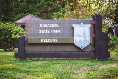
Bogachiel State Park, State park near Forks, United States.

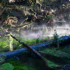
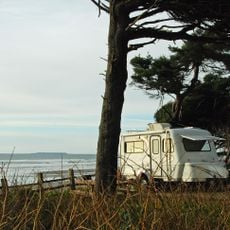
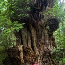
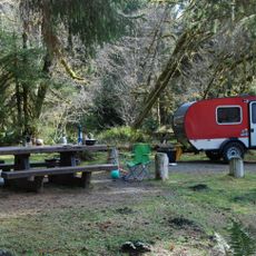
Bogachiel State Park is a 127-acre property situated along the Bogachiel River on the Olympic Peninsula. The grounds feature forest paths for walking, a campground with 42 sites (36 standard and 6 with utilities), and space for both tent and vehicle camping up to 40 feet long.

The site was established in 1931 through cooperation between the Bogachiel Improvement Club and the Forks Chamber of Commerce. This founding reflects an era when local groups took initiative to build recreational facilities for their communities.

The park draws anglers who make it their base during winter fishing season, gathering along the river with their equipment and sharing knowledge about steelhead in the water. This practice has shaped how visitors use the space and what rhythms define the location throughout the year.

The location sits near Forks with good access for both day visitors and overnight campers arriving from nearby areas. Visitor facilities vary with the season, and the park uses an alternate water supply station during winter months when the main system is shut down.

The park includes covered picnic structures and infrastructure positioned directly at the river specifically built to support fishing tourism. These facilities reveal how the area early recognized the importance of its river resources to the local economy and visitor needs.

Location: Clallam County

Operator: Washington State Parks and Recreation Commission

Website: https://parks.state.wa.us/478/Bogachiel

GPS coordinates: 47.89763,-124.35997

Latest update: December 12, 2025 14:25

Photos
Around this place
Ruby Beach
United States of America

Ruby Beach

21.2 km
La Push Beach
United States of America

La Push Beach

20.9 km
Sol Duc Hot Springs
United States of America

Sol Duc Hot Springs

37.9 km
Hall of Mosses Trail
United States of America

Hall of Mosses Trail

32.5 km
Olympic Coast National Marine Sanctuary
United States of America

Olympic Coast National Marine Sanctuary

33.4 km
One Square Inch of Silence
United States of America

One Square Inch of Silence

36.7 km
Destruction Island Lighthouse
United States of America

Destruction Island Lighthouse

26.6 km
Quillayute Needles National Wildlife Refuge
United States of America

Quillayute Needles National Wildlife Refuge

27.3 km
Eagle Ranger Station
United States of America

Eagle Ranger Station

37.9 km
Peter Roose Homestead
United States of America

Peter Roose Homestead

39.1 km
Kloshe Nanitch Lookout
United States of America

Kloshe Nanitch Lookout

29.2 km
Forks Timber Museum
United States of America

Forks Timber Museum

5 km
Forks Timber Museum
United States of America

Forks Timber Museum

5 km
Wedding Rock Petroglyphs
United States of America

Wedding Rock Petroglyphs

38.7 km
Pacific coastal area of Olympic National Park
United States of America

Pacific coastal area of Olympic National Park

16.5 km
Hoh Rain Forest Visitor Center
United States of America

Hoh Rain Forest Visitor Center

32 km
Forks Loggers Memorial
United States of America

Forks Loggers Memorial

5 km
Beach 1
United States of America

Beach 1

36.1 km
Sol Duc River Bridge
United States of America

Sol Duc River Bridge

19.9 km
Hole-in-the-Wall
United States of America

Hole-in-the-Wall

22.3 km
Kalaloch Campground
United States of America

Kalaloch Campground

31.7 km
Middle Rock
United States of America

Middle Rock

18.1 km
Hoh Head
United States of America

Hoh Head

16.9 km
Forks Visitor Information Center
United States of America

Forks Visitor Information Center

5 km
Yellow Banks
United States of America

Yellow Banks

32.9 km
Big Cedar Tree
United States of America

Big Cedar Tree

24.9 km
Fairholme Campground
United States of America

Fairholme Campground

38.4 km
Hoh Campground
United States of America

Hoh Campground

32 km
Show the full map
Reviews

Visited this place? Tap the stars to rate it and share your experience / photos with the community! Try now! You can cancel it anytime.

« Bogachiel State Park - State park near Forks, United States » is provided by Around Us (aroundus.com). Images and texts are derived from Wikimedia project under a Creative Commons license. You are allowed to copy, distribute, and modify copies of this page, under the conditions set by the license, as long as this note is clearly visible.

Discover hidden gems everywhere you go!

From secret cafés to breathtaking viewpoints, skip the crowded tourist spots and find places that match your style. Our app makes it easy with voice search, smart filtering, route optimization, and insider tips from travelers worldwide. Download now for the complete mobile experience.

Around Us App Screenshot

A unique approach to discovering new places

Le Figaro

All the places worth exploring

France Info

A tailor-made excursion in just a few clicks

20 Minutes