Enable Location

We need your location to show you interesting places around you

Discover nearby places

Find interesting locations and hidden gems around you

Precise directions

Get accurate directions and distances to places

Your location is never shared with other users. It's only used when you tap the location button.

Destruction Island Lighthouse

Log in to your account

Start exploring — it's free

Trusted by 62,373 travelers worldwide

Continue with Google
Continue with Apple
or

We will send you a code to connect

By continuing, you accept our Terms and Conditions and our Privacy Policy

Check your inbox

We've sent a pincode in your inbox. Please enter the code below.

Destruction Island Lighthouse

Destruction Island Lighthouse, Coastal lighthouse on Destruction Island, Washington, United States.

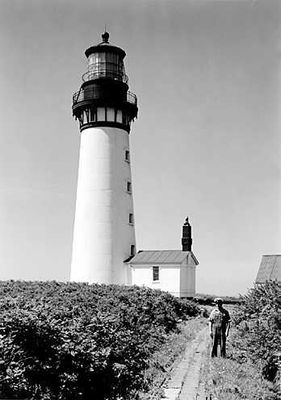
Destruction Island Lighthouse is a white beacon structure standing on a remote rocky island about 3 kilometers off the Washington coast. The tower rises roughly 29 meters tall and features iron reinforcements designed to withstand harsh ocean conditions and coastal weather.

Construction started in 1890 after years of funding challenges, and the lighthouse first shone on January 1, 1892 to guide ships at sea. It served maritime navigation for more than 100 years before ceasing operations in 2008.

The first-order Fresnel lens, manufactured in France by Henry Le Paute in 1888, now resides at the Westport Maritime Museum for public viewing.

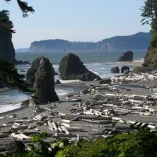
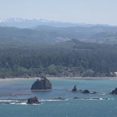
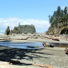
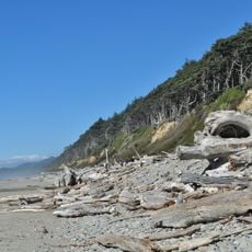
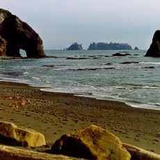
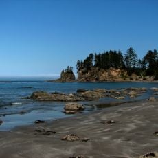
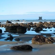
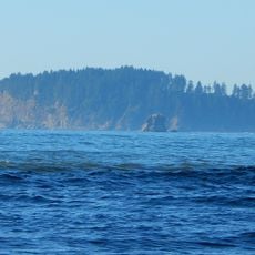
The tower sits on an uninhabited island and is not open to public visits. You can view the white structure clearly from Ruby Beach and other lookout points along Route 101, especially on clearer days.

The name comes from maritime disasters of the late 1700s when Spanish and British vessels met their end in the treacherous waters around the island. The original French-made Fresnel lens from 1888 now sits in the Westport Maritime Museum for visitors to see.

The community of curious travelers

AroundUs brings together thousands of curated places, local tips, and hidden gems, enriched daily by 60,000 contributors worldwide.

Start exploring
Location
GPS coordinates
47.67437,-124.48697
Latest update
December 12, 2025 12:00
Around this place
Olympic Mountains
United States of America

Olympic Mountains

52 km
Ruby Beach
United States of America

Ruby Beach

6.7 km
La Push Beach
United States of America

La Push Beach

28.4 km
Hall of Mosses Trail
United States of America

Hall of Mosses Trail

46.7 km
Olympic Coast National Marine Sanctuary
United States of America

Olympic Coast National Marine Sanctuary

27.8 km
One Square Inch of Silence
United States of America

One Square Inch of Silence

50.9 km
Bogachiel State Park
United States of America

Bogachiel State Park

26.6 km
Quillayute Needles National Wildlife Refuge
United States of America

Quillayute Needles National Wildlife Refuge

39.2 km
Chow Chow Bridge
United States of America

Chow Chow Bridge

42.1 km
Quinault Cultural Center and Museum
United States of America

Quinault Cultural Center and Museum

39.9 km
Copalis National Wildlife Refuge
United States of America

Copalis National Wildlife Refuge

32.8 km
Forks Timber Museum
United States of America

Forks Timber Museum

30 km
Forks Timber Museum
United States of America

Forks Timber Museum

30 km
Kestner Homestead
United States of America

Kestner Homestead

53.4 km
Pacific coastal area of Olympic National Park
United States of America

Pacific coastal area of Olympic National Park

24 km
Hoh Rain Forest Visitor Center
United States of America

Hoh Rain Forest Visitor Center

46.2 km
Forks Loggers Memorial
United States of America

Forks Loggers Memorial

30.1 km
Beach 1
United States of America

Beach 1

14.6 km
Quinault Rain Forest Ranger Station
United States of America

Quinault Rain Forest Ranger Station

53.4 km
Sol Duc River Bridge
United States of America

Sol Duc River Bridge

46.5 km
Kalaloch Campground
United States of America

Kalaloch Campground

10.8 km
Hole-in-the-Wall
United States of America

Hole-in-the-Wall

32.2 km
Yellow Banks
United States of America

Yellow Banks

49.2 km
Middle Rock
United States of America

Middle Rock

8.5 km
Forks Visitor Information Center
United States of America

Forks Visitor Information Center

30 km
Hoh Head
United States of America

Hoh Head

10.5 km
Hoh Campground
United States of America

Hoh Campground

46 km
Big Cedar Tree
United States of America

Big Cedar Tree

7.1 km
Show the full map
« Destruction Island Lighthouse - Coastal lighthouse on Destruction Island, Washington, United States » is provided by Around Us (aroundus.com). Images and texts are derived from Wikimedia project under a Creative Commons license. You are allowed to copy, distribute, and modify copies of this page, under the conditions set by the license, as long as this note is clearly visible.

Discover hidden gems everywhere you go!

From secret cafés to breathtaking viewpoints, skip the crowded tourist spots and find places that match your style. Our app makes it easy with voice search, smart filtering, route optimization, and insider tips from travelers worldwide. Download now for the complete mobile experience.

Around Us App Screenshot

A unique approach to discovering new places

Le Figaro

All the places worth exploring

France Info

A tailor-made excursion in just a few clicks

20 Minutes

Around Us
Travel Guide & Maps
Download

Send to your phone

QR Code
1

Open the camera app on your mobile.

2

Point at the QR code with your camera. A notification will appear.

3

Tap the notification to open the link.