Enable Location

We need your location to show you interesting places around you

Discover nearby places

Find interesting locations and hidden gems around you

Precise directions

Get accurate directions and distances to places

Your location is never shared with other users. It's only used when you tap the location button.

First Avenue South Bridge

Log in to your account

Start exploring — it's free

Trusted by 62,088 travelers worldwide

Continue with Google
Continue with Apple
or

We will send you a code to connect

By continuing, you accept our Terms and Conditions and our Privacy Policy

Check your inbox

We've sent a pincode in your inbox. Please enter the code below.

First Avenue South Bridge

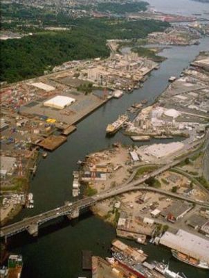
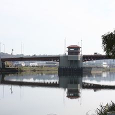
First Avenue South Bridge, Road and bascule bridge in south Seattle, US

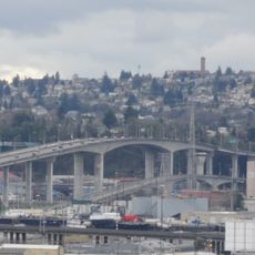
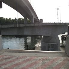
The First Avenue South Bridge is a bascule bridge with two movable leaf spans crossing the Duwamish River south of Seattle. The structure carries State Route 99 traffic and features two symmetrical hinged sections that lift to allow river traffic to pass underneath.

The original northbound span opened in 1956 and linked industrial areas with residential neighborhoods to the south and southwest. Between 1996 and 1998 a major overhaul modernized the lifting mechanism and completely rebuilt the approach roads.

The bridge functions as a central transportation artery in Seattle, influencing the development of surrounding industrial and residential communities over multiple generations.

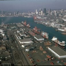
Vessels can pass through when the bridge opens, a process lasting about four minutes supervised by the US Coast Guard 13th District. The openings follow federal navigation rules, so travelers may occasionally experience traffic pauses.

The bridge regularly lifts to allow larger vessels to pass through, a dramatic sight that interrupts everyday traffic in an urban setting. These openings remind drivers that the roadway must share space with river navigation.

The community of curious travelers

AroundUs brings together thousands of curated places, local tips, and hidden gems, enriched daily by 60,000 contributors worldwide.

Start exploring
Location
Inception
1956
Official opening
1956
GPS coordinates
47.54220,-122.33400
Latest update
December 12, 2025 17:45
Around this place
The Museum of Flight
United States of America

The Museum of Flight

3.6 km
Sick's Stadium
United States of America

Sick's Stadium

5 km
Starbucks Center
United States of America

Starbucks Center

4.3 km
West Seattle Bridge
United States of America

West Seattle Bridge

3.4 km
Harbor Island
United States of America

Harbor Island

4.3 km
Spokane Street Bridge
United States of America

Spokane Street Bridge

3.6 km
Hat 'n' Boots
United States of America

Hat 'n' Boots

978 m
Georgetown Steam Plant
United States of America

Georgetown Steam Plant

1.4 km
Connections Museum
United States of America

Connections Museum

825 m
Lady Rainier
United States of America

Lady Rainier

4 km
Green River Trail
United States of America

Green River Trail

4.5 km
Dai Bai Zan Cho Bo Zen Ji
United States of America

Dai Bai Zan Cho Bo Zen Ji

4 km
South Park Bridge
United States of America

South Park Bridge

2.1 km
Oxbow Park
United States of America

Oxbow Park

958 m
Marra Farm
United States of America

Marra Farm

2.3 km
Living Computers: Museum + Labs
United States of America

Living Computers: Museum + Labs

4.5 km
Beacon Hill Branch Library
United States of America

Beacon Hill Branch Library

4.3 km
Old Georgetown City Hall
United States of America

Old Georgetown City Hall

1.6 km
Fifth Church of Christ, Scientist
United States of America

Fifth Church of Christ, Scientist

4.1 km
Columbia City Historic District
United States of America

Columbia City Historic District

4.1 km
T. Evans Wyckoff Memorial Bridge
United States of America

T. Evans Wyckoff Memorial Bridge

3.8 km
Space Gallery
United States of America

Space Gallery

3.7 km
Ark Lodge Cinemas
United States of America

Ark Lodge Cinemas

4.1 km
Columbia City Theater
United States of America

Columbia City Theater

4.1 km
Driftwood Sculpture Walk, Lincoln Park, West Seattle
United States of America

Driftwood Sculpture Walk, Lincoln Park, West Seattle

4.7 km
White Center Fieldhouse and Caretaker Cottage
United States of America

White Center Fieldhouse and Caretaker Cottage

3.7 km
Kenyon Hall
United States of America

Kenyon Hall

3.4 km
El Centro de la Raza
United States of America

El Centro de la Raza

4.6 km
Show the full map
« First Avenue South Bridge - Road and bascule bridge in south Seattle, US » is provided by Around Us (aroundus.com). Images and texts are derived from Wikimedia project under a Creative Commons license. You are allowed to copy, distribute, and modify copies of this page, under the conditions set by the license, as long as this note is clearly visible.

Discover hidden gems everywhere you go!

From secret cafés to breathtaking viewpoints, skip the crowded tourist spots and find places that match your style. Our app makes it easy with voice search, smart filtering, route optimization, and insider tips from travelers worldwide. Download now for the complete mobile experience.

Around Us App Screenshot

A unique approach to discovering new places

Le Figaro

All the places worth exploring

France Info

A tailor-made excursion in just a few clicks

20 Minutes

Around Us
Travel Guide & Maps
Download

Send to your phone

QR Code
1

Open the camera app on your mobile.

2

Point at the QR code with your camera. A notification will appear.

3

Tap the notification to open the link.