Chest opened
+${chestReward.xp} XP
Explorer
NOUVEAU ×${chestReward.collectible.quantity}
tapez pour fermer
Chest locked

Open chests in the app

Around Us is built for your phone — chests unlock when you walk, explore and capture nearby places.

Enable Location

We need your location to show you interesting places around you

Discover nearby places

Find interesting locations and hidden gems around you

Precise directions

Get accurate directions and distances to places

Your location is never shared with other users. It's only used when you tap the location button.

Log in to your account

Start exploring — it's free

Trusted by 72,957 travelers worldwide

Continue with Google
Continue with Apple
or

We will send you a code to connect

By continuing, you accept our Terms and Conditions and our Privacy Policy

Check your inbox

We've sent a pincode in your inbox. Please enter the code below.

Tagus Ranch
Discussion Reviews Photo
1.8k Popularity

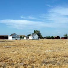
Tagus Ranch, Former agricultural complex north of Tulare, United States

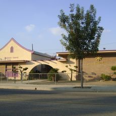
Tagus Ranch is a former agricultural complex north of Tulare that once served as a self-contained community. The property sprawled across 7,000 acres and included a restaurant, hotel, general store, post office, theater, and eleven residential camps.

The site was established in 1912 by Hulett C. Merritt as an agricultural operation. During World War II, the grounds were repurposed as a German prisoner of war camp.

The theater on the property attracted major performers like Ricky Nelson, The Platters, Merle Haggard, and Ray Charles during the 1970s and 1980s. The venue served as a gathering place where people from the surrounding area came for live music and entertainment.

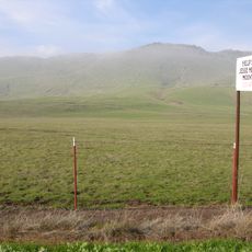
The site sits back from the main highway and is accessed via a secondary road, especially after traffic shifted to Interstate 5 in 1972. This location makes the place quieter and less visible than it was previously.

John Steinbeck started writing his novel The Grapes of Wrath at a small restaurant situated next to the property. This dining establishment became part of a larger story about California's literary heritage.

The community of curious travelers

AroundUs brings together thousands of curated places, local tips, and hidden gems, enriched daily by 60,000 contributors worldwide.

Start exploring
Location
GPS coordinates
36.27390,-119.36600
Latest update
December 14, 2025 12:22
Around this place
Colonel Allensworth State Historic Park
United States of America

Colonel Allensworth State Historic Park

44.8 km
Lake Kaweah
United States of America

Lake Kaweah

36.4 km
Zalud House
United States of America

Zalud House

38.6 km
Lake Success
United States of America

Lake Success

46.6 km
Terminus Dam
United States of America

Terminus Dam

36.2 km
Pixley National Wildlife Refuge
United States of America

Pixley National Wildlife Refuge

39.7 km
Blue Ridge National Wildlife Refuge
United States of America

Blue Ridge National Wildlife Refuge

46.8 km
Visalia Fox Theatre
United States of America

Visalia Fox Theatre

8.9 km
Ash Mountain Entrance Sign
United States of America

Ash Mountain Entrance Sign

53.1 km
Taoist Temple
United States of America

Taoist Temple

25.1 km
Sequoia Springs
United States of America

Sequoia Springs

6 km
Hanford Carnegie Museum
United States of America

Hanford Carnegie Museum

25.7 km
Bank of Italy
United States of America

Bank of Italy

9.4 km
Mill Creek
United States of America

Mill Creek

6 km
Visalia Branch Library
United States of America

Visalia Branch Library

9.2 km
Exeter Library
United States of America

Exeter Library

20.5 km
Hyde House
United States of America

Hyde House

8.9 km
Kings County Courthouse
United States of America

Kings County Courthouse

25.8 km
Orosi Branch Library
United States of America

Orosi Branch Library

30.9 km
The Pioneer
United States of America

The Pioneer

4.9 km
Jesse Morrow Mountain
United States of America

Jesse Morrow Mountain

51.6 km
Visalia Buddhist Church
United States of America

Visalia Buddhist Church

9.5 km
Kelly Slater's Wave Pool
United States of America

Kelly Slater's Wave Pool

38.2 km
Pumpkin Hollow Bridge
United States of America

Pumpkin Hollow Bridge

52.4 km
East Fork Kaweah River Bridge
United States of America

East Fork Kaweah River Bridge

55 km
Mineral King Road Cultural Landscape District
United States of America

Mineral King Road Cultural Landscape District

55 km
Reedley Beach
United States of America

Reedley Beach

35.8 km
Children’s Storybook Garden & Museum
United States of America

Children’s Storybook Garden & Museum

25.8 km
Show the full map
Reviews
Share your experience

No review yet

Discussions
Start a discussion...

No discussion yet

« Tagus Ranch - Former agricultural complex north of Tulare, United States » is provided by Around Us (aroundus.com). Images and texts are derived from Wikimedia project under a Creative Commons license. You are allowed to copy, distribute, and modify copies of this page, under the conditions set by the license, as long as this note is clearly visible.

Discover hidden gems everywhere you go!

From secret cafés to breathtaking viewpoints, skip the crowded tourist spots and find places that match your style. Our app makes it easy with voice search, smart filtering, route optimization, and insider tips from travelers worldwide. Download now for the complete mobile experience.

Around Us App Screenshot

A unique approach to discovering new places

Le Figaro

All the places worth exploring

France Info

A tailor-made excursion in just a few clicks

20 Minutes

Around Us
Travel Guide & Maps
Download

Send to your phone

QR Code
1

Open the camera app on your mobile.

2

Point at the QR code with your camera. A notification will appear.

3

Tap the notification to open the link.