Enable Location

We need your location to show you interesting places around you

Discover nearby places

Find interesting locations and hidden gems around you

Precise directions

Get accurate directions and distances to places

Your location is never shared with other users. It's only used when you tap the location button.

Terminus Dam

Log in to your account

Start exploring — it's free

Trusted by 60,665 travelers worldwide

Continue with Google
Continue with Apple
or

We will send you a code to connect

By continuing, you accept our Terms and Conditions and our Privacy Policy

Check your inbox

We've sent a pincode in your inbox. Please enter the code below.

Terminus Dam

Terminus Dam, Hydroelectric dam in Tulare County, United States.

Description

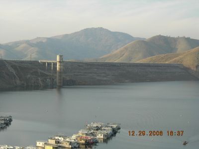
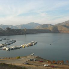
Terminus Dam is an embankment dam that holds back the Kaweah River to create Lake Kaweah in central California. The structure serves both power generation and flood control purposes for the surrounding region.

History

Construction was authorized by the Flood Control Act of 1944 and completed by the United States Army Corps of Engineers in 1962. The project was built to address flooding concerns and meet growing electricity demands in California.

Culture

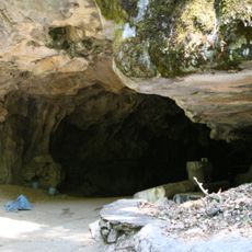
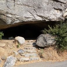
The construction site of Terminus Dam revealed numerous Native American artifacts, which the National Park Service preserved before the excavation began.

Practical

The site is generally accessible to the public, with the adjacent Lake Kaweah offering recreational activities like fishing and boating. It is wise to check local conditions before visiting since water levels fluctuate seasonally.

Did you know?

The dam features exceptionally large flood gate mechanisms that open automatically when water pressure reaches critical levels during flooding. This safety system makes it distinctive among hydroelectric projects in the area.

Location
GPS coordinates
36.41690,-119.00400
Latest update
December 11, 2025 18:03

AroundUs brings together thousands of curated places, local tips, and hidden gems, enriched daily by 60,000 contributors worldwide. Discover all places nearby (Tulare County).

Around this place
Sequoia National Park
United States of America

Sequoia National Park

26.4 km
Moro Rock
United States of America

Moro Rock

25.6 km
Lake Kaweah
United States of America

Lake Kaweah

416 m
Washington
United States of America

Washington

27.1 km
Crystal Cave
United States of America

Crystal Cave

25 km
King Arthur
United States of America

King Arthur

27.5 km
Sentinel
United States of America

Sentinel

26.4 km
Hospital Rock
United States of America

Hospital Rock

23.9 km
Blue Ridge National Wildlife Refuge
United States of America

Blue Ridge National Wildlife Refuge

20.9 km
Ash Mountain Entrance Sign
United States of America

Ash Mountain Entrance Sign

16.9 km
Hazelwood Tree
United States of America

Hazelwood Tree

26.5 km
Giant Forest Museum
United States of America

Giant Forest Museum

26.4 km
Squatter's Cabin
United States of America

Squatter's Cabin

27.5 km
Giant Forest Lodge Historic District
United States of America

Giant Forest Lodge Historic District

26.9 km
Bank of Italy
United States of America

Bank of Italy

27.2 km
Giant Forest Village-Camp Kaweah Historic District
United States of America

Giant Forest Village-Camp Kaweah Historic District

26.4 km
Exeter Library
United States of America

Exeter Library

18.2 km
Visalia Buddhist Church
United States of America

Visalia Buddhist Church

27.1 km
Pumpkin Hollow Bridge
United States of America

Pumpkin Hollow Bridge

16.3 km
East Fork Kaweah River Bridge
United States of America

East Fork Kaweah River Bridge

19.2 km
Mineral King Road Cultural Landscape District
United States of America

Mineral King Road Cultural Landscape District

19.2 km
Giant Forest Ranger Residence
United States of America

Giant Forest Ranger Residence

26.3 km
Beetle Rock Center
United States of America

Beetle Rock Center

26.2 km
Giant Forest Village Comfort Station
United States of America

Giant Forest Village Comfort Station

26.4 km
Auto Log
United States of America

Auto Log

26 km
Foothills Visitor Center
United States of America

Foothills Visitor Center

17.9 km
Indian Head River Trailhead
United States of America

Indian Head River Trailhead

16.9 km
Tunnel Rock
United States of America

Tunnel Rock

19.6 km
Show the full map
« Terminus Dam - Hydroelectric dam in Tulare County, United States » is provided by Around Us (aroundus.com). Images and texts are derived from Wikimedia project under a Creative Commons license. You are allowed to copy, distribute, and modify copies of this page, under the conditions set by the license, as long as this note is clearly visible.

Discover hidden gems everywhere you go!

From secret cafés to breathtaking viewpoints, skip the crowded tourist spots and find places that match your style. Our app makes it easy with voice search, smart filtering, route optimization, and insider tips from travelers worldwide. Download now for the complete mobile experience.

Around Us App Screenshot

A unique approach to discovering new places

Le Figaro

All the places worth exploring

France Info

A tailor-made excursion in just a few clicks

20 Minutes

Around Us
Travel Guide & Maps
Download

Send to your phone

QR Code
1

Open the camera app on your mobile.

2

Point at the QR code with your camera. A notification will appear.

3

Tap the notification to open the link.