Chest opened
+${chestReward.xp} XP
Explorer
NOUVEAU ×${chestReward.collectible.quantity}
tapez pour fermer

See the monuments around you in AR Open chests in the app

Around Us is built for your phone — point your camera at the streets and discover the monuments and places around you in augmented reality. Around Us is built for your phone — chests unlock when you walk, explore and capture nearby places.

•

Enable Location

We need your location to show you interesting places around you

Discover nearby places

Find interesting locations and hidden gems around you

Precise directions

Get accurate directions and distances to places

Your location is never shared with other users. It's only used when you tap the location button.

Lake Kaweah

Log in to your account

Start exploring — it's free

Trusted by 94,657 travelers worldwide

Continue with Google
Continue with Apple
or

We will send you a code to connect

By continuing, you accept our Terms and Conditions and our Privacy Policy

Check your inbox

We've sent a pincode in your inbox. Please enter the code below.

Lake Kaweah, Reservoir in Tulare County, California.

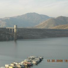
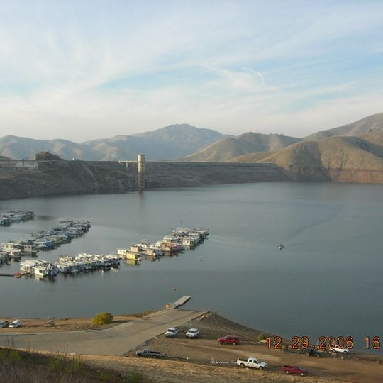
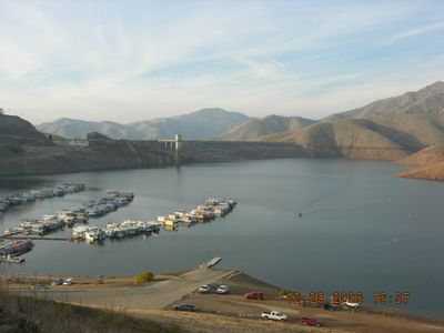
Lake Kaweah is a reservoir near Lemon Cove in Tulare County, California, formed by Terminus Dam on the Kaweah River, which rises in the Sierra Nevada. Its grey-blue water is bordered by dry tan and brown hills, with rows of floating wooden docks and boat slips near the shore and a concrete boat ramp in the foreground. The reservoir holds 185,000 acre-feet, raised by 21 feet in a project completed in 2004.

Terminus Dam was completed in 1962 by the United States Army Corps of Engineers to manage water in California's central valley. The project transformed the Kaweah River into a controlled water supply system for agricultural and flood management purposes.

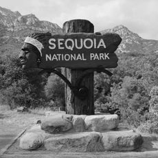
The name Kaweah comes from the Yokuts word for the river, and the Wukchumni Yokuts lived along its valley long before Terminus Dam. At the upper end of the lake sits Three Rivers, the gateway town to Sequoia National Park, where the river's forks meet.

The lake can be reached via California Highway 198 from Visalia by heading east into the foothills. You'll find camping areas, boat access, and fishing locations around the shoreline, with amenities available at several recreation areas.

During the 1997 floods the reservoir filled and emptied twice, because winter water is released as fast as possible to leave room for floodwater. In 2007, high winds from a severe thunderstorm tore loose the boat dock along the lake, affecting 200 boats.

The community of curious travelers

AroundUs brings together thousands of curated places, local tips, and hidden gems, enriched daily by 94,657 contributors worldwide.
Start exploring
Location
GPS coordinates
36.41500,-119.00000
Latest update
October 28, 2026 17:57
Around this place
Show the full map
Reviews
Share your experience

No review yet

Discussions
Start a discussion...

No discussion yet

« Lake Kaweah - Reservoir in Tulare County, California » is provided by Around Us (aroundus.com). Images and texts are derived from Wikimedia project under a Creative Commons license. You are allowed to copy, distribute, and modify copies of this page, under the conditions set by the license, as long as this note is clearly visible.

Discover hidden gems everywhere you go!

From secret cafés to breathtaking viewpoints, skip the crowded tourist spots and find places that match your style. Our app makes it easy with voice search, smart filtering, route optimization, and insider tips from travelers worldwide. Download now for the complete mobile experience.

Around Us App Screenshot
❝

A unique approach to discovering new places❞

— Le Figaro

❝

All the places worth exploring❞

— France Info

❝

A tailor-made excursion in just a few clicks❞

— 20 Minutes

Around Us
Travel Guide & Maps
Download

Send to your phone

QR Code
1

Open the camera app on your mobile.

2

Point at the QR code with your camera. A notification will appear.

3

Tap the notification to open the link.