Chest opened
+${chestReward.xp} XP
Explorer
NOUVEAU ×${chestReward.collectible.quantity}
tapez pour fermer
Chest locked

Open chests in the app

Around Us is built for your phone — chests unlock when you walk, explore and capture nearby places.

Enable Location

We need your location to show you interesting places around you

Discover nearby places

Find interesting locations and hidden gems around you

Precise directions

Get accurate directions and distances to places

Your location is never shared with other users. It's only used when you tap the location button.

Log in to your account

Start exploring — it's free

Trusted by 72,889 travelers worldwide

Continue with Google
Continue with Apple
or

We will send you a code to connect

By continuing, you accept our Terms and Conditions and our Privacy Policy

Check your inbox

We've sent a pincode in your inbox. Please enter the code below.

Madera Canal
Discussion Reviews Photo
2.1k Popularity

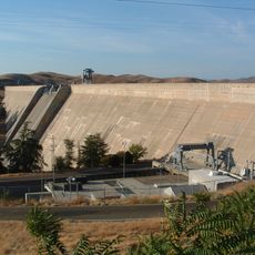
Madera Canal, Irrigation aqueduct in Madera County, California.

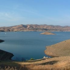
The Madera Canal is an irrigation waterway that carries water from Millerton Lake toward the Chowchilla River across the eastern valley. The canal gradually narrows as it extends eastward, delivering water to agricultural areas along its path.

The canal was completed in the mid-1940s to deliver water to valley farms. The intake structures were rebuilt around 1965 to increase how much water could flow through the system.

The canal made farming possible across this valley by delivering water to fields that would otherwise be too dry for crops. You can see the waterway running through agricultural land, shaping how the landscape is used and organized.

You can view the canal from several access points along its route through the valley. The water flow is most visible during warmer months when irrigation demand is highest and the system operates at full capacity.

This waterway is part of a massive project that transformed dry farmland into productive agriculture across an entire region. Few visitors realize that countless daily activities and food production throughout California depend on such water infrastructure.

The community of curious travelers

AroundUs brings together thousands of curated places, local tips, and hidden gems, enriched daily by 60,000 contributors worldwide.

Start exploring
Location
Location
GPS coordinates
37.00050,-119.71300
Latest update
December 14, 2025 09:44
Around this place
Save Mart Center
United States of America

Save Mart Center

21.4 km
Forestiere Underground Gardens
United States of America

Forestiere Underground Gardens

26.2 km
Valley Children's Stadium
United States of America

Valley Children's Stadium

21.1 km
Millerton Lake
United States of America

Millerton Lake

7 km
United States of America

Fresno City College

27 km
Fresno Chaffee Zoo
United States of America

Fresno Chaffee Zoo

29.3 km
Friant Dam
United States of America

Friant Dam

711 m
Tower Theatre
United States of America

Tower Theatre

28.1 km
Roeding Park
United States of America

Roeding Park

29.1 km
Fresno City Hall
United States of America

Fresno City Hall

29.8 km
Old Fresno Water Tower
United States of America

Old Fresno Water Tower

29.8 km
Fresno Art Museum
United States of America

Fresno Art Museum

26.1 km
Fresno River Viaduct
United States of America

Fresno River Viaduct

28.2 km
Island Waterpark
United States of America

Island Waterpark

26.6 km
San Joaquin River Viaduct
United States of America

San Joaquin River Viaduct

26.2 km
St. John Cathedral
United States of America

St. John Cathedral

29.6 km
Meux Home
United States of America

Meux Home

29.7 km
Wild Water Adventures
United States of America

Wild Water Adventures

24.7 km
Bowlero
United States of America

Bowlero

20 km
The William Saroyan House Museum
United States of America

The William Saroyan House Museum

26.1 km
San Joaquin
United States of America

San Joaquin

25.7 km
Fresno Memorial Auditorium
United States of America

Fresno Memorial Auditorium

29.8 km
Einstein House
United States of America

Einstein House

29.6 km
Physicians Building
United States of America

Physicians Building

29.6 km
Arboreto de la universidad estatal de California campus de Fresno
United States of America

Arboreto de la universidad estatal de California campus de Fresno

21.1 km
Clovis Botanical Garden
United States of America

Clovis Botanical Garden

20.5 km
Woodward Park Regional Library
United States of America

Woodward Park Regional Library

15.1 km
Fig Garden Regional Library
United States of America

Fig Garden Regional Library

23.2 km
Show the full map
Reviews
Share your experience

No review yet

Discussions
Start a discussion...

No discussion yet

« Madera Canal - Irrigation aqueduct in Madera County, California » is provided by Around Us (aroundus.com). Images and texts are derived from Wikimedia project under a Creative Commons license. You are allowed to copy, distribute, and modify copies of this page, under the conditions set by the license, as long as this note is clearly visible.

Discover hidden gems everywhere you go!

From secret cafés to breathtaking viewpoints, skip the crowded tourist spots and find places that match your style. Our app makes it easy with voice search, smart filtering, route optimization, and insider tips from travelers worldwide. Download now for the complete mobile experience.

Around Us App Screenshot

A unique approach to discovering new places

Le Figaro

All the places worth exploring

France Info

A tailor-made excursion in just a few clicks

20 Minutes

Around Us
Travel Guide & Maps
Download

Send to your phone

QR Code
1

Open the camera app on your mobile.

2

Point at the QR code with your camera. A notification will appear.

3

Tap the notification to open the link.