Grapevine Canyon

Log in to your account

AroundUs is a community-driven map of interesting places, built by curious explorers like you. It grows with every review, story, and photo you share.
Connect to save your favorite spots, contribute locations, and create personalized routes.
By continuing, you accept our Terms and Conditions and our Privacy Policy

Grapevine Canyon

Add to collection
Map
Suggest a change
Share

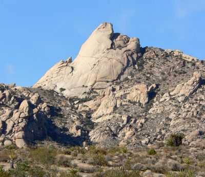
Grapevine Canyon, Ancient petroglyphs site in Clark County, Nevada.

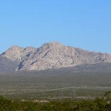
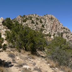
Grapevine Canyon is a narrow gorge in the Mojave Desert carved through granite rock with several natural springs and a seasonal stream running through it. The approximately 1.4-mile-long canyon features a hiking trail that leads past ancient rock carvings etched into the stone walls.

Indigenous peoples carved petroglyphs into the canyon walls over several centuries, leaving behind geometric patterns and depictions of animals and human figures. These rock carvings represent an important record of indigenous presence and artistic traditions in the region.

The rock art collection at Grapevine Canyon represents an essential record of indigenous communication and artistic expression in the Mojave Desert region.

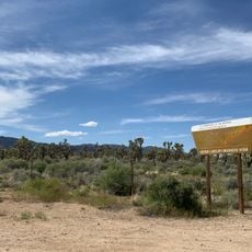
The best time to visit is spring or fall when temperatures are mild and the seasonal stream may be flowing. Bring plenty of water and sturdy footwear to safely navigate the hiking trail and rocky terrain.

Wild grapevines that give the canyon its name thrive thanks to natural springs in this otherwise arid desert landscape. These springs create a rare green microclimate where typical desert plants grow alongside moisture-loving vegetation in an unexpected combination.

Location: Clark County

GPS coordinates: 35.22710,-114.68600

Latest update: December 9, 2025 12:24

Photos
Around this place
Show the full map
Castle Mountains National Monument
United States of America

Castle Mountains National Monument

35.4 km
El Dorado Canyon
United States of America

El Dorado Canyon

53.5 km
Atchison, Topeka and Santa Fe Railway 3759
United States of America

Atchison, Topeka and Santa Fe Railway 3759

57.2 km
Grapevine Canyon Petroglyphs
United States of America

Grapevine Canyon Petroglyphs

0 m
Havasu National Wildlife Refuge
United States of America

Havasu National Wildlife Refuge

51 km
Spirit Mountain
United States of America

Spirit Mountain

6.3 km
Bigelow Cholla Garden Wilderness
United States of America

Bigelow Cholla Garden Wilderness

47.4 km
AT&T Building
United States of America

AT&T Building

57.6 km
Dead Mountains
United States of America

Dead Mountains

26.4 km
Spirit Mountain Wilderness
United States of America

Spirit Mountain Wilderness

6.2 km
Warm Springs Wilderness
United States of America

Warm Springs Wilderness

50.4 km
Bridge Canyon Wilderness
United States of America

Bridge Canyon Wilderness

1.1 km
Boundary Cone
United States of America

Boundary Cone

36.6 km
Alexey W. Von Schmidt
United States of America

Alexey W. Von Schmidt

23.8 km
Goffs Schoolhouse
United States of America

Goffs Schoolhouse

47.9 km
Mohave Museum of History and Arts
United States of America

Mohave Museum of History and Arts

56.9 km
Wee Thump Joshua Tree Wilderness, Nevada
United States of America

Wee Thump Joshua Tree Wilderness, Nevada

50.7 km
Saint Mary's Catholic Church
United States of America

Saint Mary's Catholic Church

57.7 km
Tyrell House
United States of America

Tyrell House

57.2 km
G. H. Sullivan Lodging House
United States of America

G. H. Sullivan Lodging House

57.6 km
House at 105 Spring St.
United States of America

House at 105 Spring St.

57.3 km
Foster S. Dennis House
United States of America

Foster S. Dennis House

57.5 km
Little Red School
United States of America

Little Red School

57.8 km
House at 809 Grand View
United States of America

House at 809 Grand View

57 km
J. B. Wright House
United States of America

J. B. Wright House

57.8 km
W. P. Mahoney House
United States of America

W. P. Mahoney House

57.5 km
Riverview Resort Golf Course
United States of America

Riverview Resort Golf Course

16.7 km
Cool Springs Station
United States of America

Cool Springs Station

40.9 km
Show the full map
Reviews

Visited this place? Tap the stars to rate it and share your experience / photos with the community! Try now! You can cancel it anytime.

« Grapevine Canyon - Ancient petroglyphs site in Clark County, Nevada » is provided by Around Us (aroundus.com). Images and texts are derived from Wikimedia project under a Creative Commons license. You are allowed to copy, distribute, and modify copies of this page, under the conditions set by the license, as long as this note is clearly visible.

Discover hidden gems everywhere you go!

From secret cafés to breathtaking viewpoints, skip the crowded tourist spots and find places that match your style. Our app makes it easy with voice search, smart filtering, route optimization, and insider tips from travelers worldwide. Download now for the complete mobile experience.

Around Us App Screenshot

A unique approach to discovering new places

Le Figaro

All the places worth exploring

France Info

A tailor-made excursion in just a few clicks

20 Minutes