Enable Location

We need your location to show you interesting places around you

Discover nearby places

Find interesting locations and hidden gems around you

Precise directions

Get accurate directions and distances to places

Your location is never shared with other users. It's only used when you tap the location button.

Dead Mountains

Log in to your account

Start exploring — it's free

Trusted by 60,648 travelers worldwide

Continue with Google
Continue with Apple
or

We will send you a code to connect

By continuing, you accept our Terms and Conditions and our Privacy Policy

Check your inbox

We've sent a pincode in your inbox. Please enter the code below.

Dead Mountains, Nature reserve in San Bernardino County, United States.

Description

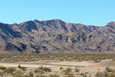
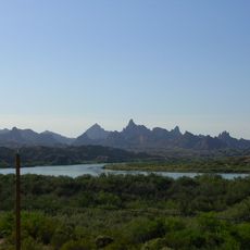
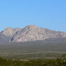
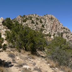
The Dead Mountains form a protected nature reserve in the Mojave Desert covering approximately 47,000 acres of wilderness. The landscape contains jagged peaks, broad alluvial fans, and deep canyons, with Mount Manchester standing as the highest point at about 3,600 feet.

History

Mining and mineral exploration dominated this region during the late 1800s and early 1900s. The area received protection as a reserve decades later to preserve the remaining wilderness from ongoing industrial development.

Culture

Native American groups passed through these mountains seasonally, relying on the rare water sources for survival. The landscape still shows traces of this long relationship with the land.

Practical

Access is limited to rough roads and hiking trails, with autumn and spring offering the most comfortable conditions. Visitors should bring ample water and supplies as the reserve has no developed facilities or services.

Did you know?

The northern section holds the only natural population of smoketrees in California's desert regions. These unusual plants thrive in the extreme conditions found nowhere else nearby.

Operator
BLM
GPS coordinates
34.99400,-114.73646
Latest update
December 12, 2025 09:01

AroundUs brings together thousands of curated places, local tips, and hidden gems, enriched daily by 60,000 contributors worldwide. Discover all places nearby (San Bernardino County).

Around this place
Lake Havasu
United States of America

Lake Havasu

65.4 km
United States of America

AN/URC-117 Ground Wave Emergency Network

52.6 km
Castle Mountains National Monument
United States of America

Castle Mountains National Monument

44.8 km
Atchison, Topeka and Santa Fe Railway 3759
United States of America

Atchison, Topeka and Santa Fe Railway 3759

65.5 km
Grapevine Canyon Petroglyphs
United States of America

Grapevine Canyon Petroglyphs

26.4 km
Old Woman meteorite
United States of America

Old Woman meteorite

64.3 km
The Needles
United States of America

The Needles

44.7 km
Havasu National Wildlife Refuge
United States of America

Havasu National Wildlife Refuge

29.8 km
Spirit Mountain
United States of America

Spirit Mountain

31.3 km
Bigelow Cholla Garden Wilderness
United States of America

Bigelow Cholla Garden Wilderness

22.5 km
Old Trails Bridge
United States of America

Old Trails Bridge

38.6 km
Red Rock Bridge
United States of America

Red Rock Bridge

38.2 km
United States of America

Topock Gorge

45.1 km
Spirit Mountain Wilderness
United States of America

Spirit Mountain Wilderness

31.7 km
Warm Springs Wilderness
United States of America

Warm Springs Wilderness

40.6 km
United States of America

Bridge Canyon Wilderness

26.5 km
Boundary Cone
United States of America

Boundary Cone

29.2 km
Grapevine Canyon
United States of America

Grapevine Canyon

26.4 km
United States of America

Alexey W. Von Schmidt

7.1 km
Goffs Schoolhouse
United States of America

Goffs Schoolhouse

30.2 km
Mohave Museum of History and Arts
United States of America

Mohave Museum of History and Arts

65.2 km
Tyrell House
United States of America

Tyrell House

65.7 km
Mohave Canyon
United States of America

Mohave Canyon

46.6 km
Foster S. Dennis House
United States of America

Foster S. Dennis House

65.6 km
House at 809 Grand View
United States of America

House at 809 Grand View

65.5 km
Area 66
United States of America

Area 66

55.9 km
Riverview Resort Golf Course
United States of America

Riverview Resort Golf Course

19.5 km
Cool Springs Station
United States of America

Cool Springs Station

39.1 km
Show the full map
« Dead Mountains - Nature reserve in San Bernardino County, United States » is provided by Around Us (aroundus.com). Images and texts are derived from Wikimedia project under a Creative Commons license. You are allowed to copy, distribute, and modify copies of this page, under the conditions set by the license, as long as this note is clearly visible.

Discover hidden gems everywhere you go!

From secret cafés to breathtaking viewpoints, skip the crowded tourist spots and find places that match your style. Our app makes it easy with voice search, smart filtering, route optimization, and insider tips from travelers worldwide. Download now for the complete mobile experience.

Around Us App Screenshot

A unique approach to discovering new places

Le Figaro

All the places worth exploring

France Info

A tailor-made excursion in just a few clicks

20 Minutes

Around Us
Travel Guide & Maps
Download

Send to your phone

QR Code
1

Open the camera app on your mobile.

2

Point at the QR code with your camera. A notification will appear.

3

Tap the notification to open the link.