Old Trails Bridge

Log in to your account

AroundUs is a community-driven map of interesting places, built by curious explorers like you. It grows with every review, story, and photo you share.
Connect to save your favorite spots, contribute locations, and create personalized routes.
Continue with Google
Continue with Apple
Continue with X
Continue with Facebook
Continue with email
By continuing, you accept our Terms and Conditions and our Privacy Policy
Create an account
Add to collection
Map
Suggest a change
Share

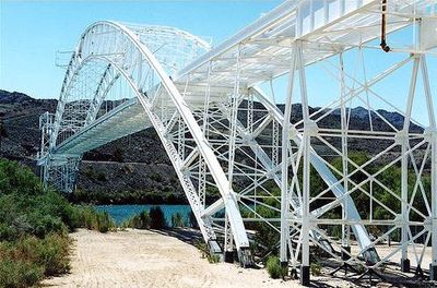
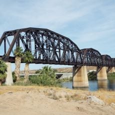
Old Trails Bridge, Through arch bridge across Colorado River between San Bernardino County, California and Mohave County, United States.

Old Trails Bridge is a steel arch bridge spanning the Colorado River between California and Arizona, with a central curved section forming its main structural element. The structure combines multiple steel framework components that work together to carry traffic across the river.

The bridge was completed in 1914 and underwent significant modification in 1928 to enhance its capacity. By 1947, it transitioned to a new purpose, no longer serving as a regular crossing for vehicles on the main highway route.

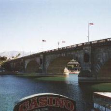
The bridge gained fame as a backdrop in classic American films that captured stories of families traveling westward during hard times. Its appearance in these movies made it a recognizable symbol of that era's journey and struggle.

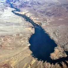
The bridge is best viewed from Interstate 40, particularly near the Park Moabi exit, which serves as the final California exit when heading eastbound. The viewing area is accessible directly from the main highway without requiring special detours.

At the time it was built, this was the longest arch bridge in America, created using an innovative cantilever construction method that was groundbreaking for that era. The engineering approach used here became an important reference for later bridge designs across the country.

Location: San Bernardino County

Location: Mohave County

GPS coordinates: 34.71580,-114.48500

Latest update: December 12, 2025 07:54

Photos
Around this place
London Bridge
United States of America

London Bridge

30 km
Lake Havasu
United States of America

Lake Havasu

27.5 km
Central Arizona Project
United States of America

Central Arizona Project

59.3 km
Colorado River Aqueduct
United States of America

Colorado River Aqueduct

55.4 km
Grapevine Canyon Petroglyphs
United States of America

Grapevine Canyon Petroglyphs

59.8 km
Buckskin Mountain State Park
United States of America

Buckskin Mountain State Park

60.3 km
The Needles
United States of America

The Needles

6.2 km
Havasu National Wildlife Refuge
United States of America

Havasu National Wildlife Refuge

8.9 km
Bigelow Cholla Garden Wilderness
United States of America

Bigelow Cholla Garden Wilderness

39.4 km
Cattail Cove State Park
United States of America

Cattail Cove State Park

49.9 km
Bill Williams River National Wildlife Refuge
United States of America

Bill Williams River National Wildlife Refuge

61.8 km
Dead Mountains
United States of America

Dead Mountains

38.6 km
Red Rock Bridge
United States of America

Red Rock Bridge

360 m
United States of America

Topock Gorge

6.5 km
Turtle Mountains
United States of America

Turtle Mountains

58.4 km
Spirit Mountain Wilderness
United States of America

Spirit Mountain Wilderness

63.1 km
Warm Springs Wilderness
United States of America

Warm Springs Wilderness

25.8 km
United States of America

Bridge Canyon Wilderness

60.4 km
Boundary Cone
United States of America

Boundary Cone

30.5 km
Grapevine Canyon
United States of America

Grapevine Canyon

59.8 km
United States of America

Alexey W. Von Schmidt

36.9 km
Goffs Schoolhouse
United States of America

Goffs Schoolhouse

56.8 km
Mohave Canyon
United States of America

Mohave Canyon

8.2 km
Bridgewater Links
United States of America

Bridgewater Links

30.5 km
Area 66
United States of America

Area 66

34.9 km
Riverview Resort Golf Course
United States of America

Riverview Resort Golf Course

44.4 km
Arizona and California Railroad Bridge
United States of America

Arizona and California Railroad Bridge

64.1 km
Cool Springs Station
United States of America

Cool Springs Station

38.2 km
Show the full map
Reviews

Visited this place? Tap the stars to rate it and share your experience / photos with the community! Try now! You can cancel it anytime.

« Old Trails Bridge - Through arch bridge across Colorado River between San Bernardino County, California and Mohave County, United States » is provided by Around Us (aroundus.com). Images and texts are derived from Wikimedia project under a Creative Commons license. You are allowed to copy, distribute, and modify copies of this page, under the conditions set by the license, as long as this note is clearly visible.

Discover hidden gems everywhere you go!

From secret cafés to breathtaking viewpoints, skip the crowded tourist spots and find places that match your style. Our app makes it easy with voice search, smart filtering, route optimization, and insider tips from travelers worldwide. Download now for the complete mobile experience.

Around Us App Screenshot

A unique approach to discovering new places

Le Figaro

All the places worth exploring

France Info

A tailor-made excursion in just a few clicks

20 Minutes