Enable Location

We need your location to show you interesting places around you

Discover nearby places

Find interesting locations and hidden gems around you

Precise directions

Get accurate directions and distances to places

Your location is never shared with other users. It's only used when you tap the location button.

Red Rock Bridge

Log in to your account

Start exploring — it's free

Trusted by 60,644 travelers worldwide

Continue with Google
Continue with Apple
or

We will send you a code to connect

By continuing, you accept our Terms and Conditions and our Privacy Policy

Check your inbox

We've sent a pincode in your inbox. Please enter the code below.

Red Rock Bridge

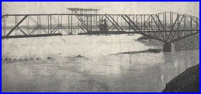
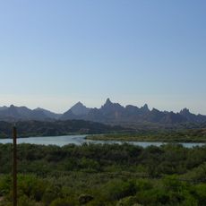
Red Rock Bridge, Railway bridge at Topock, Arizona.

Description

Red Rock Bridge spans the Colorado River near Topock with a steel cantilever through-truss design that was advanced for its time. The structure measures roughly 300 meters across the water and rises about 40 feet above the river surface.

History

Construction of this bridge began in 1890 to replace an earlier wooden crossing that suffered repeated flood damage during spring runoff. The crossing initially served rail traffic before being adapted for other purposes in subsequent decades.

Culture

The bridge appeared in the opening sequence of the 1969 film Easy Rider, gaining recognition through this cinematic moment. This appearance connected the location to American road culture and countercultural history in the public imagination.

Practical

The bridge is no longer in active use, so visitors should plan to view it as a historical structure from outside observation points. Early morning or late afternoon light tends to highlight the steel framework and details more effectively for photography.

Did you know?

The entire steel structure was assembled in less than three months, a rapid pace that reflected confidence in modern engineering methods of that era. This speed of construction stood out as a notable achievement for the time period.

GPS coordinates
34.71817,-114.48767
Latest update
December 12, 2025 09:04

AroundUs brings together thousands of curated places, local tips, and hidden gems, enriched daily by 60,000 contributors worldwide. Discover all places nearby (United States of America).

Around this place
London Bridge
United States of America

London Bridge

30.3 km
Lake Havasu
United States of America

Lake Havasu

27.8 km
Central Arizona Project
United States of America

Central Arizona Project

59.6 km
Colorado River Aqueduct
United States of America

Colorado River Aqueduct

55.8 km
Interstate 40 in California
United States of America

Interstate 40 in California

37.7 km
Grapevine Canyon Petroglyphs
United States of America

Grapevine Canyon Petroglyphs

59.5 km
Buckskin Mountain State Park
United States of America

Buckskin Mountain State Park

60.7 km
The Needles
United States of America

The Needles

6.5 km
Havasu National Wildlife Refuge
United States of America

Havasu National Wildlife Refuge

8.6 km
Bigelow Cholla Garden Wilderness
United States of America

Bigelow Cholla Garden Wilderness

39 km
Cattail Cove State Park
United States of America

Cattail Cove State Park

50.2 km
Old Trails Bridge
United States of America

Old Trails Bridge

360 m
Bill Williams River National Wildlife Refuge
United States of America

Bill Williams River National Wildlife Refuge

62.2 km
Dead Mountains
United States of America

Dead Mountains

38.2 km
United States of America

Topock Gorge

6.9 km
Turtle Mountains
United States of America

Turtle Mountains

58.5 km
Spirit Mountain Wilderness
United States of America

Spirit Mountain Wilderness

62.8 km
Warm Springs Wilderness
United States of America

Warm Springs Wilderness

25.8 km
United States of America

Bridge Canyon Wilderness

60 km
Boundary Cone
United States of America

Boundary Cone

30.3 km
Grapevine Canyon
United States of America

Grapevine Canyon

59.5 km
United States of America

Alexey W. Von Schmidt

36.6 km
Goffs Schoolhouse
United States of America

Goffs Schoolhouse

56.5 km
Mohave Canyon
United States of America

Mohave Canyon

8.6 km
Bridgewater Links
United States of America

Bridgewater Links

30.8 km
Area 66
United States of America

Area 66

35 km
Riverview Resort Golf Course
United States of America

Riverview Resort Golf Course

44.1 km
Cool Springs Station
United States of America

Cool Springs Station

38.1 km
Show the full map
« Red Rock Bridge - Railway bridge at Topock, Arizona » is provided by Around Us (aroundus.com). Images and texts are derived from Wikimedia project under a Creative Commons license. You are allowed to copy, distribute, and modify copies of this page, under the conditions set by the license, as long as this note is clearly visible.

Discover hidden gems everywhere you go!

From secret cafés to breathtaking viewpoints, skip the crowded tourist spots and find places that match your style. Our app makes it easy with voice search, smart filtering, route optimization, and insider tips from travelers worldwide. Download now for the complete mobile experience.

Around Us App Screenshot

A unique approach to discovering new places

Le Figaro

All the places worth exploring

France Info

A tailor-made excursion in just a few clicks

20 Minutes

Around Us
Travel Guide & Maps
Download

Send to your phone

QR Code
1

Open the camera app on your mobile.

2

Point at the QR code with your camera. A notification will appear.

3

Tap the notification to open the link.