Enable Location

We need your location to show you interesting places around you

Discover nearby places

Find interesting locations and hidden gems around you

Precise directions

Get accurate directions and distances to places

Your location is never shared with other users. It's only used when you tap the location button.

The Needles

Log in to your account

Start exploring — it's free

Trusted by 62,569 travelers worldwide

Continue with Google
Continue with Apple
or

We will send you a code to connect

By continuing, you accept our Terms and Conditions and our Privacy Policy

Check your inbox

We've sent a pincode in your inbox. Please enter the code below.

The Needles

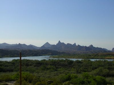
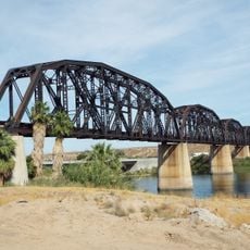
The Needles, Rock formation near Topock Gorge, Arizona, US.

The Needles are tall spires and mountain peaks that rise sharply along the Colorado River, reaching heights between 1,200 and 1,600 feet (370 to 490 meters). These distinctive formations stand out as narrow, pointed columns of rock that dominate the landscape where the river cuts through the land.

These rock spires formed over millions of years through the interaction of ancient seas, sand deposits, and tectonic forces that shaped the landscape. Two opposing systems of natural cracks in the rock created square blocks that water erosion gradually transformed into the pointed pillars visible today.

Native American tribes in the region maintain connections to these natural landmarks, which hold significance in their traditional understanding of the land.

Best viewing spots are accessible through hiking trails that run through the Havasu National Wildlife Refuge boundaries along the river. Boat tours on the Colorado River offer another way to see the formations from water level.

The rock pillars formed when two opposing series of geological joints created square blocks that water gradually sculpted into their current shapes.

The community of curious travelers

AroundUs brings together thousands of curated places, local tips, and hidden gems, enriched daily by 60,000 contributors worldwide.

Start exploring
Location
GPS coordinates
34.67600,-114.43800
Latest update
December 10, 2025 20:01
Around this place
London Bridge
United States of America

London Bridge

24.2 km
Lake Havasu
United States of America

Lake Havasu

22 km
Central Arizona Project
United States of America

Central Arizona Project

53.2 km
Colorado River Aqueduct
United States of America

Colorado River Aqueduct

49.4 km
Interstate 40 in California
United States of America

Interstate 40 in California

43.9 km
Grapevine Canyon Petroglyphs
United States of America

Grapevine Canyon Petroglyphs

65.4 km
Buckskin Mountain State Park
United States of America

Buckskin Mountain State Park

54.3 km
Havasu National Wildlife Refuge
United States of America

Havasu National Wildlife Refuge

14.9 km
Bigelow Cholla Garden Wilderness
United States of America

Bigelow Cholla Garden Wilderness

45 km
Cattail Cove State Park
United States of America

Cattail Cove State Park

43.8 km
Old Trails Bridge
United States of America

Old Trails Bridge

6.2 km
Bill Williams River National Wildlife Refuge
United States of America

Bill Williams River National Wildlife Refuge

55.7 km
Dead Mountains
United States of America

Dead Mountains

44.7 km
Red Rock Bridge
United States of America

Red Rock Bridge

6.5 km
United States of America

Topock Gorge

1.5 km
Turtle Mountains
United States of America

Turtle Mountains

57.6 km
Warm Springs Wilderness
United States of America

Warm Springs Wilderness

27.3 km
United States of America

Bridge Canyon Wilderness

66 km
Boundary Cone
United States of America

Boundary Cone

34.3 km
Grapevine Canyon
United States of America

Grapevine Canyon

65.4 km
United States of America

Alexey W. Von Schmidt

42.8 km
Goffs Schoolhouse
United States of America

Goffs Schoolhouse

62.6 km
Mohave Canyon
United States of America

Mohave Canyon

3.1 km
Bridgewater Links
United States of America

Bridgewater Links

24.7 km
Area 66
United States of America

Area 66

33.7 km
Riverview Resort Golf Course
United States of America

Riverview Resort Golf Course

49.7 km
Arizona and California Railroad Bridge
United States of America

Arizona and California Railroad Bridge

58.7 km
Cool Springs Station
United States of America

Cool Springs Station

40.9 km
Show the full map
« The Needles - Rock formation near Topock Gorge, Arizona, US » is provided by Around Us (aroundus.com). Images and texts are derived from Wikimedia project under a Creative Commons license. You are allowed to copy, distribute, and modify copies of this page, under the conditions set by the license, as long as this note is clearly visible.

Discover hidden gems everywhere you go!

From secret cafés to breathtaking viewpoints, skip the crowded tourist spots and find places that match your style. Our app makes it easy with voice search, smart filtering, route optimization, and insider tips from travelers worldwide. Download now for the complete mobile experience.

Around Us App Screenshot

A unique approach to discovering new places

Le Figaro

All the places worth exploring

France Info

A tailor-made excursion in just a few clicks

20 Minutes

Around Us
Travel Guide & Maps
Download

Send to your phone

QR Code
1

Open the camera app on your mobile.

2

Point at the QR code with your camera. A notification will appear.

3

Tap the notification to open the link.