Enable Location

We need your location to show you interesting places around you

Discover nearby places

Find interesting locations and hidden gems around you

Precise directions

Get accurate directions and distances to places

Your location is never shared with other users. It's only used when you tap the location button.

Oatman

Log in to your account

Start exploring — it's free

Trusted by travelers worldwide

Continue with Google
Continue with Apple
or

We will send you a code to connect

By continuing, you accept our Terms and Conditions and our Privacy Policy

Check your inbox

We've sent a pincode in your inbox. Please enter the code below.

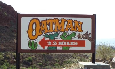
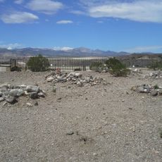
Oatman, Former mining settlement in Black Mountains, Arizona.

Description

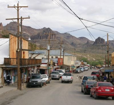
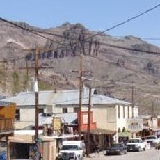
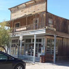
Oatman is a former mining settlement in the Black Mountains of Mohave County, Arizona. Wooden sidewalks run past weathered buildings while wild burros wander between souvenir shops and old-time saloons.

History

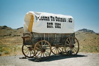
The gold discovery in 1915 turned this small settlement into a mining center with 10,000 residents before operations ended during World War II. The town sat on historic Route 66 until a new highway diverted traffic in the 1950s.

Culture

The name honors Olive Oatman, who was taken captive by Native Americans in the 1850s and later became a well-known figure in the region. Today visitors see old mining buildings converted into shops and establishments where locals sell goods and share stories from the past.

Practical

Visitors should arrive between 1:30 PM and 3:30 PM to watch the Ghost Rider Gunfighters perform street shows on the main road. Shops sell feed for the burros, and tourists should not give the animals their own food.

Did you know?

Wild burros, descendants of miners' pack animals, roam freely through the streets and approach visitors looking for food. The 1902 hotel displays thousands of dollar bills on its walls and ceiling, a tradition miners started to store money for future visits.

Location
Elevation above the sea
826 m
Address
Historic Rte 66, Oatman, AZ 86433, USA
Opening Hours
Lundi-Dimanche 09:00-18:00
Phone
GPS coordinates
35.02639,-114.38357
Latest update
December 18, 2025 19:00

AroundUs brings together thousands of curated places, local tips, and hidden gems, enriched daily by 60,000 contributors worldwide. Discover all places nearby (Mohave County).

The 100 notable ghost towns in the United States

The United States have hundreds of abandoned towns. This selection includes 100 of these places where time seems to stand still. Most grew rich in the 19th century through gold or silver finds. They attracted miners, traders, and whole families. When the veins were empty, people left. They left...

Around this place
United States of America

Big Bend of the Colorado State Recreation Area

25.4 km
United States of America

Black Mesa

9.7 km
Warm Springs Wilderness
United States of America

Warm Springs Wilderness

16 km
Boundary Cone
United States of America

Boundary Cone

5.6 km
Hardyville Cemetery
United States of America

Hardyville Cemetery

21.3 km
Durlin Hotel
United States of America

Durlin Hotel

62 m
United States of America

Mount Nutt Wilderness

9.1 km
Oatman Drug Company Building
United States of America

Oatman Drug Company Building

157 m
Riverview Resort Golf Course
United States of America

Riverview Resort Golf Course

19.6 km
United States of America

Cimarron Lake

21.5 km
United States of America

Squaw Beach (historical)

19.9 km
Cool Springs Station
United States of America

Cool Springs Station

6.8 km
United States of America

Chaparral Golf Course

21.1 km
United States of America

Start znak Route 66

7.4 km
United States of America

Mojave Resort Golf Club

24.2 km
United States of America

Huukan Golf Club (ex Desert Lakes Golf Course)

18.4 km
United States of America

Laughlin Ranch Golf Course

18.1 km
United States of America

Los Lagos Golf Course

18.2 km
United States of America

Cool Springs Station Museum

7.2 km
United States of America

El Rio Golf & Country Club

20.1 km
United States of America

Desert Dig-ins

73 m
United States of America

Oatman Jail

111 m

Oatman Outlaws

28 m
United States of America

Poki, World's Largest Desert Tortoise

21.1 km
United States of America

Upper Overlook

24.5 km
United States of America

Dam Overlook

25 km
United States of America

Tri-State Viewpoint

2.8 km
United States of America

Lower Overlook

24.3 km
Show the full map
« Oatman - Former mining settlement in Black Mountains, Arizona » is provided by Around Us (aroundus.com). Images and texts are derived from Wikimedia project under a Creative Commons license. You are allowed to copy, distribute, and modify copies of this page, under the conditions set by the license, as long as this note is clearly visible.

Discover hidden gems everywhere you go!

From secret cafés to breathtaking viewpoints, skip the crowded tourist spots and find places that match your style. Our app makes it easy with voice search, smart filtering, route optimization, and insider tips from travelers worldwide. Download now for the complete mobile experience.

Around Us App Screenshot

A unique approach to discovering new places

Le Figaro

All the places worth exploring

France Info

A tailor-made excursion in just a few clicks

20 Minutes

Around Us
Travel Guide & Maps
Download

Send to your phone

QR Code
1

Open the camera app on your mobile.

2

Point at the QR code with your camera. A notification will appear.

3

Tap the notification to open the link.