Enable Location

We need your location to show you interesting places around you

Discover nearby places

Find interesting locations and hidden gems around you

Precise directions

Get accurate directions and distances to places

Your location is never shared with other users. It's only used when you tap the location button.

Hardyville Cemetery

Log in to your account

Start exploring — it's free

Trusted by 62,589 travelers worldwide

Continue with Google
Continue with Apple
or

We will send you a code to connect

By continuing, you accept our Terms and Conditions and our Privacy Policy

Check your inbox

We've sent a pincode in your inbox. Please enter the code below.

Hardyville Cemetery, pioneer cemetery in Bullhead City, Mohave County, Arizona, US

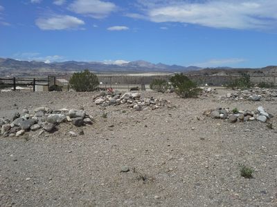
Hardyville Cemetery is a small burial ground near Arizona State Route 95 in Mohave County with 17 known graves marked with simple piles of stones. The site is surrounded by a plain fence and has a quiet feeling, with some stones showing names and dates that remember the early settlers and miners.

The settlement of Hardyville was founded in 1864 by William R. Hardy and became an important point for river shipping and ferry crossings on the Colorado River. After 1883, when the ferry moved to Needles, California, and a railroad was later built, the town declined and faded by the early 1900s.

The cemetery is named after William R. Hardy, who founded the settlement in 1864 as a river crossing point. Visitors and local organizations still use this place today to remember the pioneers and keep their stories alive.

The cemetery is easy to spot from Arizona State Route 95 and is marked with historical signs, making it simple for visitors to find. It is an open area with simple paths for walking, but you should move carefully among the graves and treat the stones and markers with respect.

The graves are marked with simple piles of stones, a traditional method showing how early inhabitants used natural materials to honor their dead. This plain marking style sets this cemetery apart from modern burial grounds and gives insight into the original burial practices of the pioneer era.

The community of curious travelers

AroundUs brings together thousands of curated places, local tips, and hidden gems, enriched daily by 60,000 contributors worldwide.

Start exploring
Location
GPS coordinates
35.12082,-114.58736
Latest update
February 9, 2026 08:20
Around this place
Castle Mountains National Monument
United States of America

Castle Mountains National Monument

47.6 km
Atchison, Topeka and Santa Fe Railway 3759
United States of America

Atchison, Topeka and Santa Fe Railway 3759

48.8 km
Grapevine Canyon Petroglyphs
United States of America

Grapevine Canyon Petroglyphs

14.9 km
Havasu National Wildlife Refuge
United States of America

Havasu National Wildlife Refuge

37.5 km
Spirit Mountain
United States of America

Spirit Mountain

21.2 km
Bigelow Cholla Garden Wilderness
United States of America

Bigelow Cholla Garden Wilderness

42.1 km
AT&T Building
United States of America

AT&T Building

49.2 km
Old Trails Bridge
United States of America

Old Trails Bridge

46 km
Dead Mountains
United States of America

Dead Mountains

19.6 km
Red Rock Bridge
United States of America

Red Rock Bridge

45.7 km
Spirit Mountain Wilderness
United States of America

Spirit Mountain Wilderness

17.1 km
Warm Springs Wilderness
United States of America

Warm Springs Wilderness

35.7 km
United States of America

Bridge Canyon Wilderness

15.7 km
Boundary Cone
United States of America

Boundary Cone

21.8 km
Grapevine Canyon
United States of America

Grapevine Canyon

14.9 km
United States of America

Alexey W. Von Schmidt

13.7 km
Goffs Schoolhouse
United States of America

Goffs Schoolhouse

48.1 km
Mohave Museum of History and Arts
United States of America

Mohave Museum of History and Arts

48.5 km
Saint Mary's Catholic Church
United States of America

Saint Mary's Catholic Church

49.3 km
Tyrell House
United States of America

Tyrell House

48.8 km
G. H. Sullivan Lodging House
United States of America

G. H. Sullivan Lodging House

49.1 km
Hubbs House
United States of America

Hubbs House

49.3 km
House at 105 Spring St.
United States of America

House at 105 Spring St.

48.9 km
Foster S. Dennis House
United States of America

Foster S. Dennis House

48.9 km
House at 809 Grand View
United States of America

House at 809 Grand View

48.6 km
W. P. Mahoney House
United States of America

W. P. Mahoney House

49.1 km
Riverview Resort Golf Course
United States of America

Riverview Resort Golf Course

1.8 km
Cool Springs Station
United States of America

Cool Springs Station

27.4 km
Show the full map
« Hardyville Cemetery - pioneer cemetery in Bullhead City, Mohave County, Arizona, US » is provided by Around Us (aroundus.com). Images and texts are derived from Wikimedia project under a Creative Commons license. You are allowed to copy, distribute, and modify copies of this page, under the conditions set by the license, as long as this note is clearly visible.

Discover hidden gems everywhere you go!

From secret cafés to breathtaking viewpoints, skip the crowded tourist spots and find places that match your style. Our app makes it easy with voice search, smart filtering, route optimization, and insider tips from travelers worldwide. Download now for the complete mobile experience.

Around Us App Screenshot

A unique approach to discovering new places

Le Figaro

All the places worth exploring

France Info

A tailor-made excursion in just a few clicks

20 Minutes

Around Us
Travel Guide & Maps
Download

Send to your phone

QR Code
1

Open the camera app on your mobile.

2

Point at the QR code with your camera. A notification will appear.

3

Tap the notification to open the link.