Enable Location

We need your location to show you interesting places around you

Discover nearby places

Find interesting locations and hidden gems around you

Precise directions

Get accurate directions and distances to places

Your location is never shared with other users. It's only used when you tap the location button.

Log in to your account

Start exploring — it's free

Trusted by 62,924 travelers worldwide

Continue with Google
Continue with Apple
or

We will send you a code to connect

By continuing, you accept our Terms and Conditions and our Privacy Policy

Check your inbox

We've sent a pincode in your inbox. Please enter the code below.

Boucher Trail
Discussion Reviews Photo
1.9k Popularity

Boucher Trail, Steep hiking trail in Grand Canyon National Park, United States

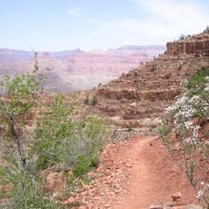
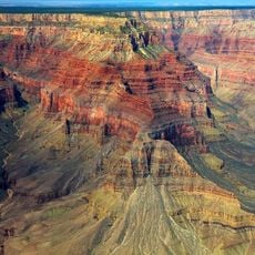
Boucher Trail is a demanding hiking route in Grand Canyon National Park that descends from the South Rim to the Colorado River over roughly 9 miles. The path crosses multiple rock formations and navigates steep switchbacks as it works its way down into the canyon.

The trail was established in the late 1800s by Louis D. Boucher, a prospector who lived in the Hermit Creek basin for roughly two decades. Boucher originally named the route Silver Bell Trail before it eventually took his own name.

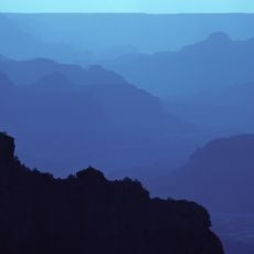
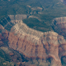
The path reveals the geological history of the Grand Canyon through distinct rock layers, providing scientific insights into North American continental formation.

Hikers should carry plenty of water since natural sources are limited to Boucher Creek and the Colorado River downstream. Camping is done in designated areas below the main trail, and permits are needed before setting out.

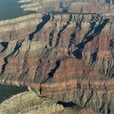
The route passes near Yuma Point where a short section demands exposed scrambling. The camp area below offers open views across the canyon landscape that many hikers find memorable.

The community of curious travelers

AroundUs brings together thousands of curated places, local tips, and hidden gems, enriched daily by 60,000 contributors worldwide.

Start exploring
Location
GPS coordinates
36.06010,-112.23600
Latest update
December 14, 2025 11:43
Around this place
Grand Canyon National Park
United States of America

Grand Canyon National Park

10.3 km
Bright Angel Trail
United States of America

Bright Angel Trail

8.4 km
El Tovar Hotel
United States of America

El Tovar Hotel

8.9 km
Bright Angel Lodge
United States of America

Bright Angel Lodge

8.6 km
Hopi House
United States of America

Hopi House

8.9 km
Hermit's Rest
United States of America

Hermit's Rest

2.2 km
Kolb Studio
United States of America

Kolb Studio

8.4 km
Hermit Trail
United States of America

Hermit Trail

2.2 km
Grand Canyon Depot
United States of America

Grand Canyon Depot

9 km
Grand Canyon Village Historic District
United States of America

Grand Canyon Village Historic District

8.8 km
Lookout Studio
United States of America

Lookout Studio

8.5 km
Buckey O'Neill Cabin
United States of America

Buckey O'Neill Cabin

8.5 km
Rim Trail
United States of America

Rim Trail

8.2 km
Mary Jane Colter buildings
United States of America

Mary Jane Colter buildings

8.5 km
Grand Canyon South Rim Ranger's Dormitory
United States of America

Grand Canyon South Rim Ranger's Dormitory

9 km
Grand Canyon Power House
United States of America

Grand Canyon Power House

8.6 km
Grand Canyon National Park Superintendent's Residence
United States of America

Grand Canyon National Park Superintendent's Residence

9.1 km
Grand Canyon Park Operations Building
United States of America

Grand Canyon Park Operations Building

8.9 km
Horus Temple
United States of America

Horus Temple

9.5 km
Grand Canyon Water Reclamation Plant
United States of America

Grand Canyon Water Reclamation Plant

7.3 km
El Tovar Stables
United States of America

El Tovar Stables

8.6 km
Hermit Canyon
United States of America

Hermit Canyon

2.2 km
Topaz Canyon
United States of America

Topaz Canyon

5.6 km
Cocopa Point
United States of America

Cocopa Point

3.2 km
Verkamp's Visitor Center
United States of America

Verkamp's Visitor Center

9 km
Horace M. Albright Training Center
United States of America

Horace M. Albright Training Center

9.3 km
Bright Angel Trailhead
United States of America

Bright Angel Trailhead

8.3 km
Indian Garden Campground
United States of America

Indian Garden Campground

9.8 km
Show the full map
Reviews
Share your experience

No review yet

Discussions
Start a discussion...

No discussion yet

« Boucher Trail - Steep hiking trail in Grand Canyon National Park, United States » is provided by Around Us (aroundus.com). Images and texts are derived from Wikimedia project under a Creative Commons license. You are allowed to copy, distribute, and modify copies of this page, under the conditions set by the license, as long as this note is clearly visible.

Discover hidden gems everywhere you go!

From secret cafés to breathtaking viewpoints, skip the crowded tourist spots and find places that match your style. Our app makes it easy with voice search, smart filtering, route optimization, and insider tips from travelers worldwide. Download now for the complete mobile experience.

Around Us App Screenshot

A unique approach to discovering new places

Le Figaro

All the places worth exploring

France Info

A tailor-made excursion in just a few clicks

20 Minutes

Around Us
Travel Guide & Maps
Download

Send to your phone

QR Code
1

Open the camera app on your mobile.

2

Point at the QR code with your camera. A notification will appear.

3

Tap the notification to open the link.