Enable Location

We need your location to show you interesting places around you

Discover nearby places

Find interesting locations and hidden gems around you

Precise directions

Get accurate directions and distances to places

Your location is never shared with other users. It's only used when you tap the location button.

Boca Reservoir

Log in to your account

Start exploring — it's free

Trusted by 62,376 travelers worldwide

Continue with Google
Continue with Apple
or

We will send you a code to connect

By continuing, you accept our Terms and Conditions and our Privacy Policy

Check your inbox

We've sent a pincode in your inbox. Please enter the code below.

Boca Reservoir

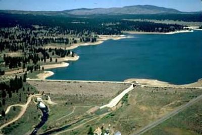
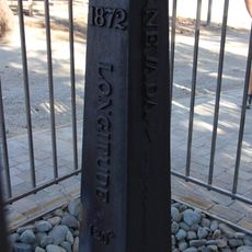
Boca Reservoir, artificial lake in California, USA

Boca Reservoir is a man-made lake in Nevada County, California, formed by damming the Little Truckee River within Tahoe National Forest. The water supply comes primarily from the Little Truckee River, which maintains fresh water flow while the dam regulates water levels and manages seasonal fluctuations from snowmelt and rainfall.

The reservoir was created several decades ago as part of the Truckee Storage Project to provide water storage and flood control for the region. Since its construction, it has become a key component of the local water management system serving nearby communities.

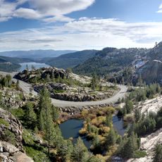
The reservoir is accessible year-round and sits about one mile north of Interstate 80 for easy access from surrounding towns. Visitors will find fishing platforms with accessible ramps, nearby campgrounds, picnic areas, and hiking trails for various activity levels.

The water freezes over during winter months, allowing for ice fishing and creating a completely different landscape from the open-water season. This seasonal transformation offers visitors distinct activities and views depending on when they arrive.

The community of curious travelers

AroundUs brings together thousands of curated places, local tips, and hidden gems, enriched daily by 60,000 contributors worldwide.

Start exploring
Location
GPS coordinates
39.39010,-120.09500
Latest update
February 7, 2026 11:40
Around this place
Donner Pass
United States of America

Donner Pass

21.2 km
Donner Memorial State Park
United States of America

Donner Memorial State Park

14.9 km
Bowers Mansion
United States of America

Bowers Mansion

24.8 km
Galena Creek Bridge
United States of America

Galena Creek Bridge

26.5 km
United States of America

Mount Pluto, California

17 km
1872 California-Nevada State Boundary Marker
United States of America

1872 California-Nevada State Boundary Marker

17 km
Castle Peak
United States of America

Castle Peak

22 km
Crystal Peak
United States of America

Crystal Peak

18.7 km
Granite Chief
United States of America

Granite Chief

27 km
Reno Nevada Temple
United States of America

Reno Nevada Temple

23.3 km
Donner Peak
United States of America

Donner Peak

20.8 km
Greystone Castle
United States of America

Greystone Castle

27.3 km
Old Winters Ranch/Winters Mansion
United States of America

Old Winters Ranch/Winters Mansion

25.1 km
Kruger House
United States of America

Kruger House

10.7 km
California Building
United States of America

California Building

26.9 km
United States of America

Mount Lincoln

23.1 km
Watson Log Cabin
United States of America

Watson Log Cabin

24.6 km
Twaddle-Pedroli Ranch
United States of America

Twaddle-Pedroli Ranch

26.2 km
C. Clifton Young Federal Building and U.S. Courthouse
United States of America

C. Clifton Young Federal Building and U.S. Courthouse

27.1 km
Chapel of the Transfiguration
United States of America

Chapel of the Transfiguration

26.7 km
Galena Creek Schoolhouse
United States of America

Galena Creek Schoolhouse

24.1 km
Withers Log House
United States of America

Withers Log House

18.9 km
Commercial Row-Brickelltown Historic District
United States of America

Commercial Row-Brickelltown Historic District

10.5 km
KidZone Museum
United States of America

KidZone Museum

12.6 km
Grand Lodge Casino
United States of America

Grand Lodge Casino

21.2 km
Burnt Cedar Beach
United States of America

Burnt Cedar Beach

19.4 km
Kings Beach State Recreation Area
United States of America

Kings Beach State Recreation Area

18.1 km
Booth Street Bridge
United States of America

Booth Street Bridge

27.3 km
Show the full map
« Boca Reservoir - artificial lake in California, USA » is provided by Around Us (aroundus.com). Images and texts are derived from Wikimedia project under a Creative Commons license. You are allowed to copy, distribute, and modify copies of this page, under the conditions set by the license, as long as this note is clearly visible.

Discover hidden gems everywhere you go!

From secret cafés to breathtaking viewpoints, skip the crowded tourist spots and find places that match your style. Our app makes it easy with voice search, smart filtering, route optimization, and insider tips from travelers worldwide. Download now for the complete mobile experience.

Around Us App Screenshot

A unique approach to discovering new places

Le Figaro

All the places worth exploring

France Info

A tailor-made excursion in just a few clicks

20 Minutes

Around Us
Travel Guide & Maps
Download

Send to your phone

QR Code
1

Open the camera app on your mobile.

2

Point at the QR code with your camera. A notification will appear.

3

Tap the notification to open the link.