Enable Location

We need your location to show you interesting places around you

Discover nearby places

Find interesting locations and hidden gems around you

Precise directions

Get accurate directions and distances to places

Your location is never shared with other users. It's only used when you tap the location button.

Twin Falls

Log in to your account

Start exploring — it's free

Trusted by 65,198 travelers worldwide

Continue with Google
Continue with Apple
or

We will send you a code to connect

By continuing, you accept our Terms and Conditions and our Privacy Policy

Check your inbox

We've sent a pincode in your inbox. Please enter the code below.

Twin Falls
Discussion Reviews 1 Photos
6.5k Popularity

Twin Falls, Natural waterfall in Southern Idaho, United States.

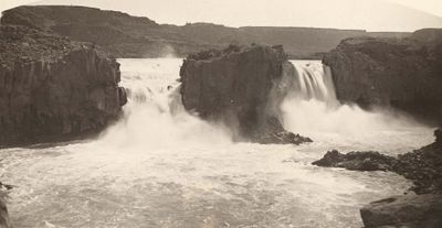
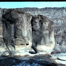
Twin Falls is a waterfall on the Snake River in southern Idaho, dropping into a deep canyon carved through layers of volcanic basalt rock. Just above the drop, the river splits into two separate streams that fall side by side, which is how the site got its name.

The area around the falls was used by Shoshone people for fishing, particularly for salmon, long before settlers arrived. In the early 20th century, dams were built on the Snake River upstream, which changed the volume and appearance of the falls over time.

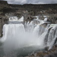
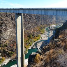
The waterfall sits right next to the city that shares its name, making it a familiar backdrop for local life. People come here to walk along the rim and look down into the canyon from the viewing platforms.

The falls are viewed from the rim of the canyon, where paved paths and open overlooks make it easy to get a clear view without climbing down. Visiting on a weekday or in the morning helps avoid crowds, especially during summer.

Despite having two falls in its name, only one is usually visible today because much of the river's water is diverted for irrigation upstream. Both falls can be seen at the same time only when the river runs unusually high, typically in spring.

The community of curious travelers

AroundUs brings together thousands of curated places, local tips, and hidden gems, enriched daily by 60,000 contributors worldwide.

Start exploring
Location
Part of
Snake River
GPS coordinates
42.58920,-114.35700
Latest update
March 3, 2026 10:10
Around this place
Shoshone Falls
United States of America

Shoshone Falls

3.8 km
Snake River Canyon
United States of America

Snake River Canyon

4.8 km
Perrine Bridge
United States of America

Perrine Bridge

8 km
Twin Falls Idaho Temple
United States of America

Twin Falls Idaho Temple

7 km
Pillar Falls
United States of America

Pillar Falls

6.2 km
Hansen Bridge
United States of America

Hansen Bridge

5.3 km
Archie Webster House
United States of America

Archie Webster House

20.5 km
Canyonside School
United States of America

Canyonside School

15.8 km
Jerome City Pump House
United States of America

Jerome City Pump House

19.4 km
Falls City School House
United States of America

Falls City School House

11.5 km
Jerome County Courthouse
United States of America

Jerome County Courthouse

20.1 km
Frank J. Brick House
United States of America

Frank J. Brick House

19.6 km
Julian T. Ricketts House
United States of America

Julian T. Ricketts House

11.5 km
E. C. Gleason House
United States of America

E. C. Gleason House

19.7 km
Dick Callen House
United States of America

Dick Callen House

16.3 km
Jacob B. Van Wagener Barn
United States of America

Jacob B. Van Wagener Barn

12.5 km
Edgar Johnson House
United States of America

Edgar Johnson House

16 km
Joseph Mandl House
United States of America

Joseph Mandl House

20 km
George Epperson House
United States of America

George Epperson House

12.5 km
O. J. Daniels House
United States of America

O. J. Daniels House

15 km
John F. Schmerschall House
United States of America

John F. Schmerschall House

19.8 km
Burton Morse House
United States of America

Burton Morse House

9.1 km
Achille Duquesne House
United States of America

Achille Duquesne House

21.1 km
Lincoln Elementary School
United States of America

Lincoln Elementary School

10.2 km
Dierkes Lake Park
United States of America

Dierkes Lake Park

2.7 km
Twin Falls City Park Historic District
United States of America

Twin Falls City Park Historic District

9.5 km
Shoshone Falls Park
United States of America

Shoshone Falls Park

4.1 km
Twin Falls Milling and Elevator Company Warehouse
United States of America

Twin Falls Milling and Elevator Company Warehouse

10.4 km
Show the full map
Reviews
Share your experience

No review yet

Discussions
Start a discussion...

No discussion yet

« Twin Falls - Natural waterfall in Southern Idaho, United States » is provided by Around Us (aroundus.com). Images and texts are derived from Wikimedia project under a Creative Commons license. You are allowed to copy, distribute, and modify copies of this page, under the conditions set by the license, as long as this note is clearly visible.

Discover hidden gems everywhere you go!

From secret cafés to breathtaking viewpoints, skip the crowded tourist spots and find places that match your style. Our app makes it easy with voice search, smart filtering, route optimization, and insider tips from travelers worldwide. Download now for the complete mobile experience.

Around Us App Screenshot

A unique approach to discovering new places

Le Figaro

All the places worth exploring

France Info

A tailor-made excursion in just a few clicks

20 Minutes

Around Us
Travel Guide & Maps
Download

Send to your phone

QR Code
1

Open the camera app on your mobile.

2

Point at the QR code with your camera. A notification will appear.

3

Tap the notification to open the link.