Enable Location

We need your location to show you interesting places around you

Discover nearby places

Find interesting locations and hidden gems around you

Precise directions

Get accurate directions and distances to places

Your location is never shared with other users. It's only used when you tap the location button.

Shoshone Falls

Log in to your account

Start exploring — it's free

Trusted by 62,911 travelers worldwide

Continue with Google
Continue with Apple
or

We will send you a code to connect

By continuing, you accept our Terms and Conditions and our Privacy Policy

Check your inbox

We've sent a pincode in your inbox. Please enter the code below.

Shoshone Falls
Discussion Reviews 3 Photos 1 Collections
64.3k Popularity

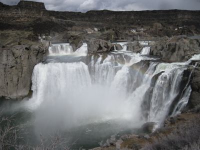
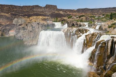
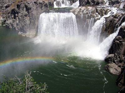
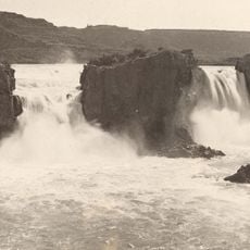
Shoshone Falls, Waterfall in Twin Falls, Idaho.

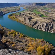
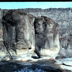
Shoshone Falls sits along the Snake River in Idaho and drops roughly 65 meters over a width approaching one kilometer. The water tumbles over cliffs of dark basalt rock that formed during ancient volcanic activity and were carved by the river channel.

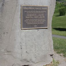
The falls took shape roughly 14,000 years ago when massive floods from Lake Bonneville cut through volcanic rock and carved the present canyon. European exploration reached the region only in the 1840s and brought settlers and trade routes with it.

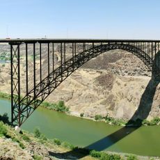
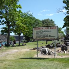
The falls bear the name of the Shoshone people, whose territory once covered much of present-day Idaho. Visitors today come to use the viewing platforms along the rim and to picnic in the quieter areas above the drop.

The park charges a vehicle fee between March and September and offers trails plus designated picnic areas near the upper rim. Visitors can use several viewpoints spread along the rim that involve short walks from parking spots.

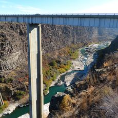
Water volume shifts dramatically depending on the season and peaks during spring snowmelt before dropping noticeably in summer. Upstream irrigation draws reduce the flow so much that the basin below often appears calmer than during the melt period.

The community of curious travelers

AroundUs brings together thousands of curated places, local tips, and hidden gems, enriched daily by 60,000 contributors worldwide.

Start exploring
Location
Elevation above the sea
992 m
Height
64.7 m
Width
992 m
Part of
Snake River
GPS coordinates
42.59601,-114.40216
Latest update
December 12, 2025 18:07
The most beautiful waterfalls and cascades in the world

Waterfalls draw you in through your senses. You hear the roar of falling water, feel the mist on your skin, and watch light dance across the spray. Many of the most powerful examples are found in places that stay relatively untouched, where reaching them is half the reward. These destinations give...

Around this place
Snake River Canyon
United States of America

Snake River Canyon

998 m
Perrine Bridge
United States of America

Perrine Bridge

4.3 km
Twin Falls
United States of America

Twin Falls

3.8 km
Twin Falls Idaho Temple
United States of America

Twin Falls Idaho Temple

3.4 km
Pillar Falls
United States of America

Pillar Falls

2.4 km
Hansen Bridge
United States of America

Hansen Bridge

9 km
Archie Webster House
United States of America

Archie Webster House

17.5 km
Canyonside School
United States of America

Canyonside School

12.3 km
Jerome City Pump House
United States of America

Jerome City Pump House

16.6 km
Falls City School House
United States of America

Falls City School House

9.6 km
Jerome County Courthouse
United States of America

Jerome County Courthouse

17.3 km
Frank J. Brick House
United States of America

Frank J. Brick House

16.9 km
Julian T. Ricketts House
United States of America

Julian T. Ricketts House

9.6 km
E. C. Gleason House
United States of America

E. C. Gleason House

16.9 km
Dick Callen House
United States of America

Dick Callen House

13 km
Jacob B. Van Wagener Barn
United States of America

Jacob B. Van Wagener Barn

10.1 km
Edgar Johnson House
United States of America

Edgar Johnson House

12.7 km
Joseph Mandl House
United States of America

Joseph Mandl House

17.3 km
George Epperson House
United States of America

George Epperson House

9.6 km
O. J. Daniels House
United States of America

O. J. Daniels House

11.5 km
John F. Schmerschall House
United States of America

John F. Schmerschall House

17 km
Burton Morse House
United States of America

Burton Morse House

6.1 km
Achille Duquesne House
United States of America

Achille Duquesne House

17.5 km
Lincoln Elementary School
United States of America

Lincoln Elementary School

7.1 km
Dierkes Lake Park
United States of America

Dierkes Lake Park

1.1 km
Twin Falls City Park Historic District
United States of America

Twin Falls City Park Historic District

6.7 km
Shoshone Falls Park
United States of America

Shoshone Falls Park

522 m
Twin Falls Milling and Elevator Company Warehouse
United States of America

Twin Falls Milling and Elevator Company Warehouse

7.6 km
Show the full map
Reviews
Share your experience

No review yet

Discussions
Start a discussion...

No discussion yet

« Shoshone Falls - Waterfall in Twin Falls, Idaho » is provided by Around Us (aroundus.com). Images and texts are derived from Wikimedia project under a Creative Commons license. You are allowed to copy, distribute, and modify copies of this page, under the conditions set by the license, as long as this note is clearly visible.

Discover hidden gems everywhere you go!

From secret cafés to breathtaking viewpoints, skip the crowded tourist spots and find places that match your style. Our app makes it easy with voice search, smart filtering, route optimization, and insider tips from travelers worldwide. Download now for the complete mobile experience.

Around Us App Screenshot

A unique approach to discovering new places

Le Figaro

All the places worth exploring

France Info

A tailor-made excursion in just a few clicks

20 Minutes

Around Us
Travel Guide & Maps
Download

Send to your phone

QR Code
1

Open the camera app on your mobile.

2

Point at the QR code with your camera. A notification will appear.

3

Tap the notification to open the link.