El Malpais National Monument

Log in to your account

AroundUs is a community-driven map of interesting places, built by curious explorers like you. It grows with every review, story, and photo you share.
Connect to save your favorite spots, contribute locations, and create personalized routes.
By continuing, you accept our Terms and Conditions and our Privacy Policy
Add to collection
Map
Suggest a change
Share

El Malpais National Monument, Volcanic terrain conservation area in western New Mexico, United States
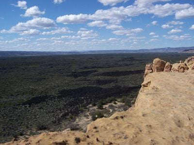
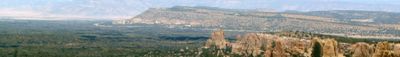
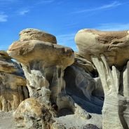
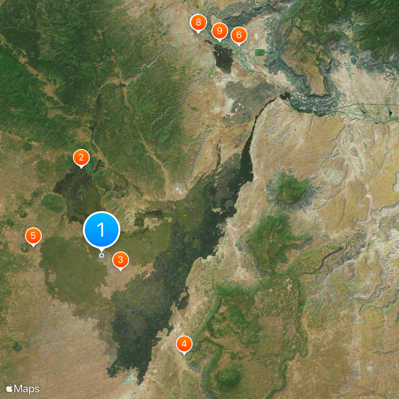
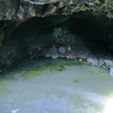
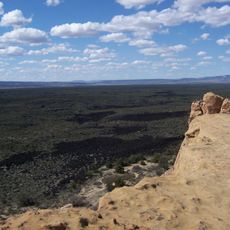
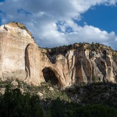
The landscape contains numerous lava flows, deep caves, ancient sandstone bluffs, and expansive ice caves across 114,276 acres of protected wilderness.

The National Monument, established in 1987, preserves geological formations dating back thousands of years, including five major lava flows and multiple volcanic vents.

Native American tribes from Acoma, Laguna, and Zuni Pueblos maintain traditional connections to this land through ceremonial practices and material gathering.

Visitors require free caving permits to explore Junction Bridge and Giant Ice Cave, while bringing adequate water supplies remains essential due to limited facilities.

The monument contains rare hart's-tongue ferns discovered inside caves, marking the first documented population west of the Mississippi River in North America.

Location: New Mexico

Inception: 1987

Operator: National Park Service

Website: https://nps.gov/elma

GPS coordinates: 34.87722,-108.05083

Latest update: May 27, 2025 10:03

National parks and monuments in Southwestern US

The southwestern United States encompasses desert landscapes, sandstone formations and archaeological sites from several pre-Columbian cultures. The region spans Utah, Arizona, New Mexico and Colorado, featuring geological structures shaped over millions of years by wind and water erosion. National parks such as Canyonlands and Capitol Reef display canyons, mesas and rock spires in shades of red, orange and ochre. The area preserves evidence of the Ancestral Puebloans, who built cliff dwellings and communal structures between the 12th and 14th centuries. Sites like Bandelier National Monument and Gila Cliff Dwellings provide access to these habitations. Chaco Culture National Historical Park documents a pre-Hispanic trading center with multistory stone complexes. Petroglyphs at locations such as Three Rivers and the petrified trees of Petrified Forest National Park offer additional historical records. The Navajo Nation administers Monument Valley and the Navajo Zoo, while Hubbell Trading Post operates as a functioning 19th-century trading post. Volcanic features mark Sunset Crater and El Malpais, while White Sands covers more than 275 square miles (700 square kilometers) of gypsum dunes. Glen Canyon and the man-made Lake Cochiti provide water access in this largely arid region. Elevation differences range from the Organ Pipe Cactus Desert to Great Basin National Park with its ridges above 13,000 feet (3,900 meters).

Natural sites and historic places in New Mexico

New Mexico combines geological formations with historical sites spanning multiple periods. The region includes cave systems such as Carlsbad Caverns, extensive gypsum fields at White Sands, volcanic landscapes at El Malpais National Monument, and unusual rock formations in the Bisti/De-Na-Zin Wilderness. The territory also preserves evidence of pre-Columbian and Spanish settlement, including pueblo ruins, cliff dwellings, and seventeenth-century mission complexes. Sites range from ancient petroglyphs at Three Rivers to military installations like Fort Union. Natural attractions include hot springs at Jemez Springs, the volcanic crater of Valles Caldera, and the deep blue waters of Blue Hole. The collection features archaeological monuments such as Chaco Culture and Bandelier, geological curiosities like the hoodoos at Tent Rocks, and historic pueblos including Taos, which has been continuously inhabited for over a thousand years.

Around this place
Show the full map
Mount Taylor
United States of America

Mount Taylor

57 km
The Lightning Field
United States of America

The Lightning Field

40.4 km
Fort Wingate
United States of America

Fort Wingate

79.4 km
Hawikuh Ruins
United States of America

Hawikuh Ruins

85.5 km
El Rancho Hotel & Motel
United States of America

El Rancho Hotel & Motel

94.8 km
Bandera Volcano Ice Cave
United States of America

Bandera Volcano Ice Cave

13.1 km
Bluewater Lake State Park
United States of America

Bluewater Lake State Park

46.8 km
Enchanted Mesa
United States of America

Enchanted Mesa

45.9 km
El Malpais National Conservation Area
United States of America

El Malpais National Conservation Area

3.4 km
San Estevan Del Rey Mission Church
United States of America

San Estevan Del Rey Mission Church

42.8 km
Dowa Yalanne
United States of America

Dowa Yalanne

70.4 km
Cebolla Wilderness
United States of America

Cebolla Wilderness

18.5 km
Acoma Curio Shop
United States of America

Acoma Curio Shop

47.4 km
Datil-Mogollon Section
United States of America

Datil-Mogollon Section

48.1 km
Sacred Heart Cathedral
United States of America

Sacred Heart Cathedral

95.3 km
Grant meteorite
United States of America

Grant meteorite

36.3 km
Kin Ya-ah
United States of America

Kin Ya-ah

89.1 km
San Jose de la Laguna Mission and Convento
United States of America

San Jose de la Laguna Mission and Convento

62.9 km
Bowlin's Old Crater Trading Post
United States of America

Bowlin's Old Crater Trading Post

45.7 km
McKinley County Courthouse
United States of America

McKinley County Courthouse

95.6 km
Grants-Milan Flight Service Station
United States of America

Grants-Milan Flight Service Station

35.1 km
Roy T. Herman's Garage and Service Station
United States of America

Roy T. Herman's Garage and Service Station

60 km
Charley's Automotive Service
United States of America

Charley's Automotive Service

35.3 km
Redwood Lodge
United States of America

Redwood Lodge

95.4 km
Drake Hotel
United States of America

Drake Hotel

95.8 km
United States Post Office
United States of America

United States Post Office

95.8 km
Lebanon Lodge No. 22
United States of America

Lebanon Lodge No. 22

95.7 km
Sky City Cultural Center and Haak'u Museum

Sky City Cultural Center and Haak'u Museum

42.4 km
Show the full map

Reviews

Visited this place? Tap the stars to rate it and share your experience / photos with the community! Try now! You can cancel it anytime.

« El Malpais National Monument - Volcanic terrain conservation area in western New Mexico, United States » is provided by Around Us (aroundus.com). Images and texts are derived from Wikimedia project under a Creative Commons license. You are allowed to copy, distribute, and modify copies of this page, under the conditions set by the license, as long as this note is clearly visible.

Discover hidden gems everywhere you go!

From secret cafés to breathtaking viewpoints, skip the crowded tourist spots and find places that match your style. Our app makes it easy with voice search, smart filtering, route optimization, and insider tips from travelers worldwide. Download now for the complete mobile experience.

Around Us App Screenshot

A unique approach to discovering new places

Le Figaro

All the places worth exploring

France Info

A tailor-made excursion in just a few clicks

20 Minutes