Raton Mesa

Log in to your account

AroundUs is a community-driven map of interesting places, built by curious explorers like you. It grows with every review, story, and photo you share.
Connect to save your favorite spots, contribute locations, and create personalized routes.
Continue with Google
Continue with Apple
Continue with X
Continue with Facebook
Continue with email
By continuing, you accept our Terms and Conditions and our Privacy Policy
Create an account
Add to collection
Map
Suggest a change
Share

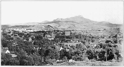
Raton Mesa, National Natural Landmark in Las Animas County, Colorado.

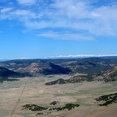
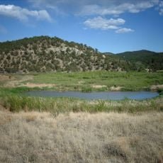
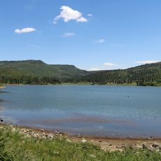
Raton Mesa is a highland formation straddling the Colorado-New Mexico border, composed of three separate ridges divided by deep canyons with Fishers Peak as its highest point. The terrain features steep cliff faces and flat grassland caps across the entire formation.

The formation developed from ancient lava flows that shaped the landscape over millions of years. Federal designation as a National Natural Landmark came in 1967 to protect its geological significance.

The mesa supports diverse wildlife including black bears, cougars, mule deer, and elk herds that move through the deep canyons separating the ridges. Visitors often encounter signs of these animals while exploring the terrain.

Access to the area is available through several state parks and wildlife areas that serve as entry points for exploration. Visitors should prepare for varying terrain conditions and bring layers of clothing since the elevation affects weather changes.

The Colorado portion of the mesa was privately owned until 2019 when a collaboration of organizations purchased it to establish state park protection. This acquisition preserved the area from potential development.

Location: Colorado

GPS coordinates: 37.03330,-104.40000

Latest update: December 8, 2025 21:00

Photos
Around this place
Raton Pass
United States of America

Raton Pass

9 km
Vermejo Park Ranch
United States of America

Vermejo Park Ranch

20.1 km
Folsom Site
United States of America

Folsom Site

33.8 km
Trinidad Lake State Park
United States of America

Trinidad Lake State Park

19.6 km
Sugarite Canyon State Park
United States of America

Sugarite Canyon State Park

8.3 km
Raton Downtown Historic District
United States of America

Raton Downtown Historic District

15.3 km
United States of America

Penitente Canyon

26 km
Frank G. Bloom House
United States of America

Frank G. Bloom House

18 km
Trinidad History Museum
United States of America

Trinidad History Museum

17.7 km
St. John's Methodist Episcopal Church
United States of America

St. John's Methodist Episcopal Church

21.8 km
Colfax County Courthouse
United States of America

Colfax County Courthouse

14.8 km
First Baptist Church
United States of America

First Baptist Church

18.5 km
Cokedale Historic District
United States of America

Cokedale Historic District

23 km
Our Lady of Guadalupe Church and Medina Cemetery
United States of America

Our Lady of Guadalupe Church and Medina Cemetery

37.1 km
Earl School
United States of America

Earl School

34.8 km
Corazon de Trinidad
United States of America

Corazon de Trinidad

17.7 km
Frank Latuda House
United States of America

Frank Latuda House

18.7 km
Baca House and Outbuilding
United States of America

Baca House and Outbuilding

17.7 km
El Raton Theatre
United States of America

El Raton Theatre

15 km
Aultman House
United States of America

Aultman House

18.9 km
Jaffa Opera House
United States of America

Jaffa Opera House

17.7 km
Columbian School
United States of America

Columbian School

14.1 km
Longfellow School
United States of America

Longfellow School

15.4 km
Original Townsite Historic District
United States of America

Original Townsite Historic District

15.4 km
Bridge over Burro Cañon
United States of America

Bridge over Burro Cañon

31.8 km
Ludlow Monument
United States of America

Ludlow Monument

35.7 km
Raton Museum
United States of America

Raton Museum

15 km
A.R. Mitchell Memorial Museum Of Western Art
United States of America

A.R. Mitchell Memorial Museum Of Western Art

17.7 km
Show the full map
Reviews

Visited this place? Tap the stars to rate it and share your experience / photos with the community! Try now! You can cancel it anytime.

« Raton Mesa - National Natural Landmark in Las Animas County, Colorado » is provided by Around Us (aroundus.com). Images and texts are derived from Wikimedia project under a Creative Commons license. You are allowed to copy, distribute, and modify copies of this page, under the conditions set by the license, as long as this note is clearly visible.

Discover hidden gems everywhere you go!

From secret cafés to breathtaking viewpoints, skip the crowded tourist spots and find places that match your style. Our app makes it easy with voice search, smart filtering, route optimization, and insider tips from travelers worldwide. Download now for the complete mobile experience.

Around Us App Screenshot

A unique approach to discovering new places

Le Figaro

All the places worth exploring

France Info

A tailor-made excursion in just a few clicks

20 Minutes