Chest opened
+${chestReward.xp} XP
Explorer
NOUVEAU ×${chestReward.collectible.quantity}
tapez pour fermer
Chest locked

Open chests in the app

Around Us is built for your phone — chests unlock when you walk, explore and capture nearby places.

Enable Location

We need your location to show you interesting places around you

Discover nearby places

Find interesting locations and hidden gems around you

Precise directions

Get accurate directions and distances to places

Your location is never shared with other users. It's only used when you tap the location button.

Rulison

Log in to your account

Start exploring — it's free

Trusted by 72,880 travelers worldwide

Continue with Google
Continue with Apple
or

We will send you a code to connect

By continuing, you accept our Terms and Conditions and our Privacy Policy

Check your inbox

We've sent a pincode in your inbox. Please enter the code below.

Discussion Reviews 1 Photos
16.6k Popularity

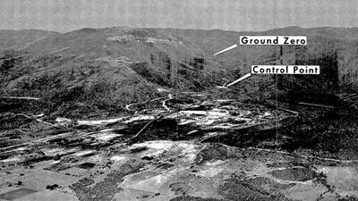
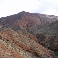
Rulison, 40-kiloton nuclear test project

Rulison is a former underground nuclear weapons test site in Colorado, about 8 miles southeast of Parachute. The explosion occurred approximately 2.5 miles below the surface and created a large cavity underground while leaving no damage at ground level.

The test took place in 1969 as part of Operation Mandrel, a program exploring peaceful uses of nuclear weapons. The project ended in failure because the released natural gas was radioactively contaminated and unsuitable for use.

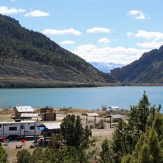
The site is named after a nearby creek and became known through this government project. The area reflects the industrial heritage of ranchers and oil workers who experienced this event as part of their region's energy development.

The area is a restricted zone where drilling and digging are prohibited to prevent disturbance of possible underground contamination. A plaque marks the exact location and is accessible via a gravel road, though visitors should check beforehand if access is permitted.

About 270 families from nearby Parachute were evacuated for the test and experienced the blast firsthand with ground shaking and visible disturbances. This mass evacuation remains one of the strangest chapters in America's peaceful nuclear energy experiment history.

The community of curious travelers

AroundUs brings together thousands of curated places, local tips, and hidden gems, enriched daily by 60,000 contributors worldwide.

Start exploring
GPS coordinates
39.40530,-107.94900
Latest update
February 17, 2026 02:01
Around this place
Hotel Colorado
United States of America

Hotel Colorado

56 km
Rifle Falls State Park
United States of America

Rifle Falls State Park

36.8 km
Glenwood Hot Springs Pool
United States of America

Glenwood Hot Springs Pool

56.1 km
Rifle Gap State Park
United States of America

Rifle Gap State Park

30.5 km
Vega State Park
United States of America

Vega State Park

24.2 km
Harvey Gap State Park
United States of America

Harvey Gap State Park

34.3 km
Glenwood Caverns Adventure Park
United States of America

Glenwood Caverns Adventure Park

55.5 km
Cliffhanger
United States of America

Cliffhanger

56.8 km
James M. Robb – Colorado River State Park
United States of America

James M. Robb – Colorado River State Park

58.7 km
Ralph Stocker Stadium
United States of America

Ralph Stocker Stadium

63.6 km
Land's End Observatory
United States of America

Land's End Observatory

48.5 km
Storm King Mountain
United States of America

Storm King Mountain

51.4 km
CAF Rocky Mountain Wing Museum
United States of America

CAF Rocky Mountain Wing Museum

59.1 km
Western Colorado Center for the Arts
United States of America

Western Colorado Center for the Arts

63.8 km
South Canon Bridge
United States of America

South Canon Bridge

49.7 km
Mesa County Public Library District
United States of America

Mesa County Public Library District

64.8 km
Cross Orchards Historic Site
United States of America

Cross Orchards Historic Site

57.9 km
Rifle Bridge
United States of America

Rifle Bridge

19.8 km
Clifton Community Center and Church
United States of America

Clifton Community Center and Church

55.5 km
IOOF Hall
United States of America

IOOF Hall

24.2 km
First Presbyterian Church of Eckert
United States of America

First Presbyterian Church of Eckert

64.3 km
Sumers Lodge
United States of America

Sumers Lodge

55.8 km
Citizens National Bank Building
United States of America

Citizens National Bank Building

55.9 km
Starr Manor
United States of America

Starr Manor

56.2 km
North Seventh Street Historic Residential District
United States of America

North Seventh Street Historic Residential District

64.5 km
Wasson-McKay Place
United States of America

Wasson-McKay Place

10.1 km
The Art Center
United States of America

The Art Center

63.8 km
Graff Dairy
United States of America

Graff Dairy

60.3 km
Show the full map
Reviews
Share your experience

No review yet

Discussions
Start a discussion...

No discussion yet

« Rulison - 40-kiloton nuclear test project » is provided by Around Us (aroundus.com). Images and texts are derived from Wikimedia project under a Creative Commons license. You are allowed to copy, distribute, and modify copies of this page, under the conditions set by the license, as long as this note is clearly visible.

Discover hidden gems everywhere you go!

From secret cafés to breathtaking viewpoints, skip the crowded tourist spots and find places that match your style. Our app makes it easy with voice search, smart filtering, route optimization, and insider tips from travelers worldwide. Download now for the complete mobile experience.

Around Us App Screenshot

A unique approach to discovering new places

Le Figaro

All the places worth exploring

France Info

A tailor-made excursion in just a few clicks

20 Minutes

Around Us
Travel Guide & Maps
Download

Send to your phone

QR Code
1

Open the camera app on your mobile.

2

Point at the QR code with your camera. A notification will appear.

3

Tap the notification to open the link.