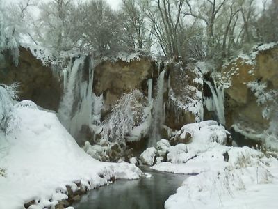
Rifle Falls State Park, Triple waterfall state park in Garfield County, Colorado.
Rifle Falls State Park is a protected area in Garfield County featuring three waterfalls dropping about 60 feet over limestone cliffs into pools below. Dense forest surrounds the site, with multiple trails connecting the different falls and allowing visitors to explore the landscape from various angles.
The site hosted one of Colorado's early hydroelectric power stations from 1910 to 1959, using the natural water flow to generate electricity. This industrial period altered the water's path and contributed to the distinctive arrangement of three separate falls visible today.
The 48-acre park attracts photographers and film crews throughout the year to capture the limestone caves and water features in western Colorado.
The park provides picnic areas and campground sites for overnight stays, accessible from multiple entry points. Visitors should wear sturdy footwear since trails near the falls can have wet and uneven surfaces.
The falls are formed by a natural travertine dam made of calcium carbonate deposited by East Rifle Creek. This mineral layer creates a specialized microclimate that supports plant and animal species found nowhere else in the surrounding region.
Location: Garfield County
Inception: 1966
Operator: Colorado Parks and Wildlife
Address: 5775 Highway 325, 10379 CO-325, Rifle, CO 81650, USA
Opening Hours: Monday-Sunday 08:00-22:00
Phone: +19706251607
Website: https://cpw.state.co.us/placestogo/Parks/RifleFalls
GPS coordinates: 39.67389,-107.70000
Latest update: December 6, 2025 16:04
Colorado contains natural areas and historical sites located away from main roads and common routes. These places tell the story of the state's geology and human history through varied landscapes. Visitors will find sand dunes, waterfalls, rock formations, and remains from the mining era. Locations...
Hanging Lake
44.3 km
Glenwood Canyon
42.4 km
Hotel Colorado
35 km
Dotsero
57 km
Glenwood Hot Springs Pool
35.1 km
Flat Top Mountain
65 km
Rifle Gap State Park
6.4 km
Flat Tops Wilderness Area
49.1 km
Vega State Park
50.7 km
Harvey Gap State Park
7.6 km
Glenwood Caverns Adventure Park
34.2 km
Cliffhanger
35.1 km
Storm King Mountain
27.3 km
South Canon Bridge
28.1 km
St. James Episcopal Church
44.4 km
First Evangelical Lutheran Church
64.2 km
Rifle Bridge
17.7 km
IOOF Hall
58.2 km
Osgood–Kuhnhausen House
67.4 km
Sumers Lodge
37.6 km
Citizens National Bank Building
35.2 km
Starr Manor
35.6 km
Missouri Heights School
55.3 km
Wasson-McKay Place
39.3 km
Hay's Ranch Bridge
50.5 km
Meeker Historic District
44.4 km
Meeker I.O.O.F. Lodge—Valentine Lodge No. 47
44.3 km
Mount Sopris
65 kmVisited this place? Tap the stars to rate it and share your experience / photos with the community! Try now! You can cancel it anytime.
Discover hidden gems everywhere you go!
From secret cafés to breathtaking viewpoints, skip the crowded tourist spots and find places that match your style. Our app makes it easy with voice search, smart filtering, route optimization, and insider tips from travelers worldwide. Download now for the complete mobile experience.
A unique approach to discovering new places❞
— Le Figaro
All the places worth exploring❞
— France Info
A tailor-made excursion in just a few clicks❞
— 20 Minutes