Chest opened
+${chestReward.xp} XP
Explorer
NOUVEAU ×${chestReward.collectible.quantity}
tapez pour fermer
Chest locked

Open chests in the app

Around Us is built for your phone — chests unlock when you walk, explore and capture nearby places.

Enable Location

We need your location to show you interesting places around you

Discover nearby places

Find interesting locations and hidden gems around you

Precise directions

Get accurate directions and distances to places

Your location is never shared with other users. It's only used when you tap the location button.

Berthoud Pass

Log in to your account

Start exploring — it's free

Trusted by 72,890 travelers worldwide

Continue with Google
Continue with Apple
or

We will send you a code to connect

By continuing, you accept our Terms and Conditions and our Privacy Policy

Check your inbox

We've sent a pincode in your inbox. Please enter the code below.

Berthoud Pass
Discussion Reviews 1 Photos
20.1k Popularity

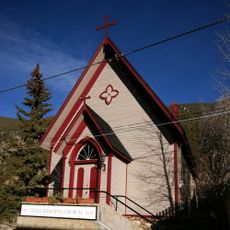
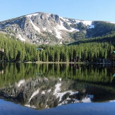
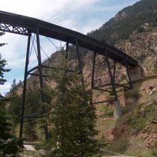
Berthoud Pass, Mountain pass in Colorado, United States.

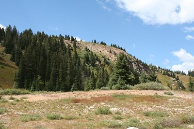
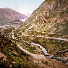
Berthoud Pass is a steep mountain pass on U.S. Highway 40 that separates Clear Creek and Grand counties. The road winds upward through numerous switchbacks, connecting both sides of the Rocky Mountains.

Edward Berthoud discovered this passage in 1861 while surveying for the Colorado Central Railroad. He determined the route was suitable for wagons but not for rail transport.

The pass marks an important section of the Continental Divide Trail, where hikers and outdoor enthusiasts experience this natural boundary and the landscape on both sides.

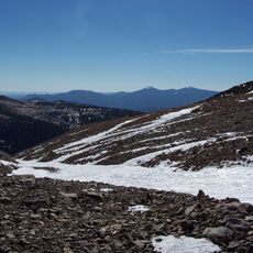
The road remains accessible year-round, though it is regularly cleared of snow during winter months. Visitors should prepare for steep grades and potentially challenging conditions during colder seasons.

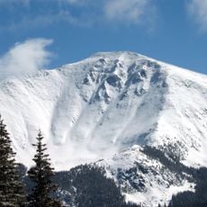
This area contains more than 50 mapped avalanche paths, making the terrain particularly hazardous. An automated propane-fueled avalanche mitigation system was installed in 2015 to protect travelers.

The community of curious travelers

AroundUs brings together thousands of curated places, local tips, and hidden gems, enriched daily by 60,000 contributors worldwide.

Start exploring
Location
Elevation above the sea
3,446 m
GPS coordinates
39.79780,-105.77700
Latest update
December 7, 2025 10:06
Around this place
Georgetown Loop Railroad
United States of America

Georgetown Loop Railroad

12.3 km
Saint Mary's Glacier
United States of America

Saint Mary's Glacier

11.9 km
Parry Peak
United States of America

Parry Peak

7.1 km
James Peak Wilderness
United States of America

James Peak Wilderness

9.6 km
Bard Peak
United States of America

Bard Peak

8.9 km
United States of America

Vasquez Peak Wilderness

5.2 km
Georgetown-Silver Plume Historic District
United States of America

Georgetown-Silver Plume Historic District

12.3 km
Engelmann Peak
United States of America

Engelmann Peak

6.2 km
Grace Episcopal Church
United States of America

Grace Episcopal Church

12.4 km
United States of America

Alpine Hose Company No. 2

12.4 km
Toll House
United States of America

Toll House

12.2 km
United States of America

Hamill House Museum

12.3 km
United States of America

Hotel De Paris Museum Georgetown Co

12.2 km
United States of America

Georgetown Energy Museum

12.3 km
United States of America

Georgetown Loop Historic Mining & Railroad Park

12.3 km
United States of America

Pavillion Point

13 km
Silver Lake
United States of America

Silver Lake

12.3 km
Devil's Gate High Bridge
United States of America

Devil's Gate High Bridge

12.4 km
United States of America

Historic Georgetown Span Sign Structure

12.1 km
United States of America

Georgetown Gallery

12.2 km
United States of America

The Mailbox

10.2 km
United States of America

Jim Bridger

8.3 km
United States of America

Georgetown Loop Overlook

12.3 km
United States of America

St. Mary's Glacier

12 km
United States of America

Scenic viewpoint

12.6 km
United States of America

Scenic viewpoint

9.8 km
United States of America

Mailbox Overlook

10.2 km
United States of America

Waterfall

12 km
Show the full map
Reviews
Share your experience

No review yet

Discussions
Start a discussion...

No discussion yet

« Berthoud Pass - Mountain pass in Colorado, United States » is provided by Around Us (aroundus.com). Images and texts are derived from Wikimedia project under a Creative Commons license. You are allowed to copy, distribute, and modify copies of this page, under the conditions set by the license, as long as this note is clearly visible.

Discover hidden gems everywhere you go!

From secret cafés to breathtaking viewpoints, skip the crowded tourist spots and find places that match your style. Our app makes it easy with voice search, smart filtering, route optimization, and insider tips from travelers worldwide. Download now for the complete mobile experience.

Around Us App Screenshot

A unique approach to discovering new places

Le Figaro

All the places worth exploring

France Info

A tailor-made excursion in just a few clicks

20 Minutes

Around Us
Travel Guide & Maps
Download

Send to your phone

QR Code
1

Open the camera app on your mobile.

2

Point at the QR code with your camera. A notification will appear.

3

Tap the notification to open the link.