Chest opened
+${chestReward.xp} XP
Explorer
NOUVEAU ×${chestReward.collectible.quantity}
tapez pour fermer
Chest locked

Open chests in the app

Around Us is built for your phone — chests unlock when you walk, explore and capture nearby places.

Enable Location

We need your location to show you interesting places around you

Discover nearby places

Find interesting locations and hidden gems around you

Precise directions

Get accurate directions and distances to places

Your location is never shared with other users. It's only used when you tap the location button.

Cache La Poudre River

Log in to your account

Start exploring — it's free

Trusted by 72,889 travelers worldwide

Continue with Google
Continue with Apple
or

We will send you a code to connect

By continuing, you accept our Terms and Conditions and our Privacy Policy

Check your inbox

We've sent a pincode in your inbox. Please enter the code below.

Cache La Poudre River
Discussion Reviews 1 Photos
15.3k Popularity

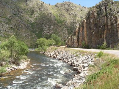
Cache La Poudre River, River in Larimer County and Weld County, United States.

The Cache la Poudre River flows eastward from the Rocky Mountains through northern Colorado, passing through varied terrain and eventually reaching the Great Plains. The water supports agriculture, provides drinking water for communities, and has carved dramatic canyons along its path.

Early settlers depended on this river to develop farms and towns across northern Colorado in the 1800s, creating complex systems to control and distribute its water. Federal protection in 1986 recognized its importance by designating much of it as a Wild and Scenic River.

The river has been central to life in northern Colorado for centuries, shaping how communities developed and how people still use the water today. Along its course, you can see how settlements grew in connection with this natural resource.

A paved trail runs alongside the river for most of its scenic course through the region, offering easy access for walking and biking at many points. Spring through fall provides the most comfortable conditions, though the water level and weather can vary depending on which section you visit.

The name comes from French meaning "powder cache," likely referring to hidden gunpowder left by early French fur trappers in the area. This unusual history connects the river to the earliest days of trade and exploration in the region.

The community of curious travelers

AroundUs brings together thousands of curated places, local tips, and hidden gems, enriched daily by 60,000 contributors worldwide.

Start exploring
Location
Location
GPS coordinates
40.42139,-104.60083
Latest update
December 7, 2025 19:30
Around this place
Dearfield
United States of America

Dearfield

32.7 km
Boyd Lake State Park
United States of America

Boyd Lake State Park

37.2 km
Nottingham Field
United States of America

Nottingham Field

9.1 km
Fort Saint Vrain
United States of America

Fort Saint Vrain

26.8 km
Fort Vasquez
United States of America

Fort Vasquez

31.4 km
Vintage Aero Flying Museum
United States of America

Vintage Aero Flying Museum

36.4 km
IHOP
United States of America

IHOP

33.7 km
Weld County Courthouse
United States of America

Weld County Courthouse

7.8 km
SLW Ranch
United States of America

SLW Ranch

9.2 km
Central Plains
United States of America

Central Plains

15.5 km
First Methodist Episcopal Church
United States of America

First Methodist Episcopal Church

26.4 km
First Baptist Church
United States of America

First Baptist Church

7.9 km
First United Presbyterian Church
United States of America

First United Presbyterian Church

40 km
Daniels School
United States of America

Daniels School

21.5 km
William H. McCreery House
United States of America

William H. McCreery House

39.8 km
Greeley Masonic Temple
United States of America

Greeley Masonic Temple

7.9 km
Greeley Tribune Building
United States of America

Greeley Tribune Building

7.5 km
Little Thompson River Bridge
United States of America

Little Thompson River Bridge

34.8 km
Anderson Barn
United States of America

Anderson Barn

31.5 km
Meeker Memorial Museum
United States of America

Meeker Memorial Museum

7.7 km
Amanda K. Alger Memorial Methodist Episcopal Church
United States of America

Amanda K. Alger Memorial Methodist Episcopal Church

15.3 km
Jared L. Brush Barn
United States of America

Jared L. Brush Barn

26.8 km
Glazier House
United States of America

Glazier House

7.9 km
Joseph A. Woodbury House
United States of America

Joseph A. Woodbury House

8.1 km
Maude Stanfield Harter Borland House
United States of America

Maude Stanfield Harter Borland House

40 km
Gray Hall
United States of America

Gray Hall

7.8 km
Nettleton-Mead House
United States of America

Nettleton-Mead House

7.8 km
Old Fort Vasquez
United States of America

Old Fort Vasquez

31.4 km
Show the full map
Reviews
Share your experience

No review yet

Discussions
Start a discussion...

No discussion yet

« Cache La Poudre River - River in Larimer County and Weld County, United States » is provided by Around Us (aroundus.com). Images and texts are derived from Wikimedia project under a Creative Commons license. You are allowed to copy, distribute, and modify copies of this page, under the conditions set by the license, as long as this note is clearly visible.

Discover hidden gems everywhere you go!

From secret cafés to breathtaking viewpoints, skip the crowded tourist spots and find places that match your style. Our app makes it easy with voice search, smart filtering, route optimization, and insider tips from travelers worldwide. Download now for the complete mobile experience.

Around Us App Screenshot

A unique approach to discovering new places

Le Figaro

All the places worth exploring

France Info

A tailor-made excursion in just a few clicks

20 Minutes

Around Us
Travel Guide & Maps
Download

Send to your phone

QR Code
1

Open the camera app on your mobile.

2

Point at the QR code with your camera. A notification will appear.

3

Tap the notification to open the link.