Enable Location

We need your location to show you interesting places around you

Discover nearby places

Find interesting locations and hidden gems around you

Precise directions

Get accurate directions and distances to places

Your location is never shared with other users. It's only used when you tap the location button.

Dale Creek Crossing

Log in to your account

Start exploring — it's free

Trusted by 63,492 travelers worldwide

Continue with Google
Continue with Apple
or

We will send you a code to connect

By continuing, you accept our Terms and Conditions and our Privacy Policy

Check your inbox

We've sent a pincode in your inbox. Please enter the code below.

Discussion Reviews 1 Photos
7.9k Popularity

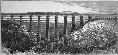
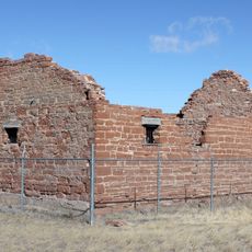
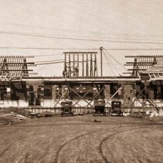
Dale Creek Crossing, Railroad bridge ruins near Laramie, United States.

Dale Creek Crossing is a railroad bridge spanning a deep gorge in Wyoming, extending roughly 220 meters across. The structure rests on massive granite masonry piers that rise about 45 meters above the stream bed.

The structure was built in 1868 as part of the transcontinental railroad and originally consisted of wood. By 1876, it was replaced with an iron framework from the American Bridge Company designed for greater longevity.

The site shows how 19th-century workers shaped and fitted stone without mortar to create stable foundations. This hands-on craftsmanship was essential to building across the challenging mountain terrain.

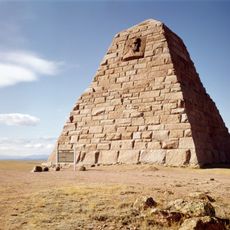
The site is located about 6 kilometers west of Ames Monument at the highest point of the Union Pacific route. The remains are visible from a dirt road and offer good views of the gorge and the old piers.

The iron bridge had to be crossed at walking pace during strong Wyoming winds due to the structure's movement. This wind sensitivity was a defining characteristic of the design that affected train operations for years.

The community of curious travelers

AroundUs brings together thousands of curated places, local tips, and hidden gems, enriched daily by 60,000 contributors worldwide.

Start exploring
Location
Architects
Union Pacific Railroad
GPS coordinates
41.10389,-105.45472
Latest update
December 8, 2025 20:00
Around this place
Ames Monument
United States of America

Ames Monument

5.6 km
War Memorial Stadium
United States of America

War Memorial Stadium

25 km
Curt Gowdy State Park
United States of America

Curt Gowdy State Park

20.9 km
Curt Gowdy State Park
United States of America

Curt Gowdy State Park

20.6 km
Abraham Lincoln Memorial Monument
United States of America

Abraham Lincoln Memorial Monument

14.9 km
Wyoming Territorial Prison State Historic Site
United States of America

Wyoming Territorial Prison State Historic Site

26.5 km
University of Wyoming College of Law
United States of America

University of Wyoming College of Law

25.2 km
Fort Sanders
United States of America

Fort Sanders

21.9 km
Old Main
United States of America

Old Main

25.6 km
United States of America

Hynds Lodge

19.6 km
Sand Creek
United States of America

Sand Creek

26.3 km
Laramie Plains Museum
United States of America

Laramie Plains Museum

25.8 km
Hutton Lake Wildlife Refuge
United States of America

Hutton Lake Wildlife Refuge

23.6 km
Snow Train Rolling Stock
United States of America

Snow Train Rolling Stock

25.6 km
St. Matthew's Cathedral
United States of America

St. Matthew's Cathedral

25.9 km
Bath Row
United States of America

Bath Row

25.9 km
Saint Paul's United Church of Christ
United States of America

Saint Paul's United Church of Christ

25.5 km
Oxford Horse Barn
United States of America

Oxford Horse Barn

14.9 km
Laramie Plains Civic Center
United States of America

Laramie Plains Civic Center

25.4 km
Laramie Downtown Historic District
United States of America

Laramie Downtown Historic District

25.7 km
Lehman-Tunnell Mansion
United States of America

Lehman-Tunnell Mansion

25.6 km
The Cooper Mansion, Laramie, Wyoming
United States of America

The Cooper Mansion, Laramie, Wyoming

25.2 km
Union Pacific Athletic Club
United States of America

Union Pacific Athletic Club

25.4 km
Charles E. Blair House
United States of America

Charles E. Blair House

26 km
John D. Conley House
United States of America

John D. Conley House

25.6 km
William Goodale House
United States of America

William Goodale House

25.3 km
Lincoln School
United States of America

Lincoln School

26.1 km
Laramie Railroad Depot
United States of America

Laramie Railroad Depot

25.7 km
Show the full map
Reviews
Share your experience

No review yet

Discussions
Start a discussion...

No discussion yet

« Dale Creek Crossing - Railroad bridge ruins near Laramie, United States » is provided by Around Us (aroundus.com). Images and texts are derived from Wikimedia project under a Creative Commons license. You are allowed to copy, distribute, and modify copies of this page, under the conditions set by the license, as long as this note is clearly visible.

Discover hidden gems everywhere you go!

From secret cafés to breathtaking viewpoints, skip the crowded tourist spots and find places that match your style. Our app makes it easy with voice search, smart filtering, route optimization, and insider tips from travelers worldwide. Download now for the complete mobile experience.

Around Us App Screenshot

A unique approach to discovering new places

Le Figaro

All the places worth exploring

France Info

A tailor-made excursion in just a few clicks

20 Minutes

Around Us
Travel Guide & Maps
Download

Send to your phone

QR Code
1

Open the camera app on your mobile.

2

Point at the QR code with your camera. A notification will appear.

3

Tap the notification to open the link.