Enable Location

We need your location to show you interesting places around you

Discover nearby places

Find interesting locations and hidden gems around you

Precise directions

Get accurate directions and distances to places

Your location is never shared with other users. It's only used when you tap the location button.

National Historic Trails Interpretive Center

Log in to your account

Start exploring — it's free

Trusted by 61,652 travelers worldwide

Continue with Google
Continue with Apple
or

We will send you a code to connect

By continuing, you accept our Terms and Conditions and our Privacy Policy

Check your inbox

We've sent a pincode in your inbox. Please enter the code below.

National Historic Trails Interpretive Center

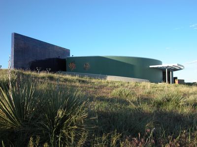
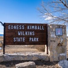
National Historic Trails Interpretive Center, Interpretation center in Casper, Wyoming, United States.

Description

The National Historic Trails Interpretive Center contains seven exhibition galleries with life-size displays and multimedia presentations about westward migration. The galleries cover multiple historic routes and detail the journeys of the people who traveled them.

History

The center documents the journeys of hundreds of thousands of people who traveled the Oregon, Mormon, California, and Pony Express routes between 1841 and 1868. These routes were central pathways of American westward expansion during that era.

Culture

The exhibitions show how pioneers made daily choices and adapted to harsh conditions during their westward journeys. Visitors can experience how family bonds and shared faith shaped the decisions of those who traveled these routes.

Practical

The center offers orientation services, information about the historic trails, and a gift shop for visitors. The facility includes restrooms and accessible options for people with mobility needs.

Did you know?

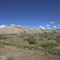
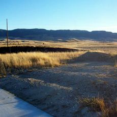
The 500-acre property contains four miles of interpretive trails featuring original wagon wheel marks carved into the ground by 19th-century emigrants. These preserved grooves remain visible today and show the actual paths people traveled long ago.

Location
Inception
2002
GPS coordinates
42.86650,-106.33700
Latest update
December 12, 2025 12:07

AroundUs brings together thousands of curated places, local tips, and hidden gems, enriched daily by 60,000 contributors worldwide. Discover all places nearby (Wyoming).

Around this place
Independence Rock
United States of America

Independence Rock

77 km
Teapot Rock
United States of America

Teapot Rock

40.9 km
Fort Caspar
United States of America

Fort Caspar

4.3 km
Casper Mountain
United States of America

Casper Mountain

12.8 km
Ayres Natural Bridge Park
United States of America

Ayres Natural Bridge Park

61 km
Pathfinder Dam
United States of America

Pathfinder Dam

61.3 km
Edness K. Wilkins State Park
United States of America

Edness K. Wilkins State Park

13.2 km
Pathfinder National Wildlife Refuge
United States of America

Pathfinder National Wildlife Refuge

67.4 km
Bishop House
United States of America

Bishop House

42.2 km
Rialto Theatre
United States of America

Rialto Theatre

2.2 km
Masonic Temple
United States of America

Masonic Temple

2.1 km
Casper Downtown Historic District
United States of America

Casper Downtown Historic District

2.2 km
United States of America

Church of Saint Anthony

2.7 km
Midwest Oil Company Hotel
United States of America

Midwest Oil Company Hotel

2.7 km
Elks Lodge No. 1353
United States of America

Elks Lodge No. 1353

2.7 km
Odd Fellows Building
United States of America

Odd Fellows Building

2 km
Roosevelt School
United States of America

Roosevelt School

1.1 km
Ohio Oil Company Building
United States of America

Ohio Oil Company Building

2.1 km
North Casper Clubhouse
United States of America

North Casper Clubhouse

2.1 km
DUX Bessemer Bend Bridge
United States of America

DUX Bessemer Bend Bridge

19 km
Consolidated Royalty Building
United States of America

Consolidated Royalty Building

2.2 km
Commerce Block
United States of America

Commerce Block

38 km
Ewing T. Kerr Federal Building and U.S. Courthouse
United States of America

Ewing T. Kerr Federal Building and U.S. Courthouse

2.2 km
Tribune Building (Casper, Wyoming)
United States of America

Tribune Building (Casper, Wyoming)

2.3 km
Casper Motor Company-Natrona Motor Company
United States of America

Casper Motor Company-Natrona Motor Company

2.2 km
South Wolcott Street Historic District
United States of America

South Wolcott Street Historic District

3.2 km
America Stadium Theatre
United States of America

America Stadium Theatre

2.1 km
Pathfinder Dam Historic District
United States of America

Pathfinder Dam Historic District

61.3 km
Show the full map
« National Historic Trails Interpretive Center - Interpretation center in Casper, Wyoming, United States » is provided by Around Us (aroundus.com). Images and texts are derived from Wikimedia project under a Creative Commons license. You are allowed to copy, distribute, and modify copies of this page, under the conditions set by the license, as long as this note is clearly visible.

Discover hidden gems everywhere you go!

From secret cafés to breathtaking viewpoints, skip the crowded tourist spots and find places that match your style. Our app makes it easy with voice search, smart filtering, route optimization, and insider tips from travelers worldwide. Download now for the complete mobile experience.

Around Us App Screenshot

A unique approach to discovering new places

Le Figaro

All the places worth exploring

France Info

A tailor-made excursion in just a few clicks

20 Minutes

Around Us
Travel Guide & Maps
Download

Send to your phone

QR Code
1

Open the camera app on your mobile.

2

Point at the QR code with your camera. A notification will appear.

3

Tap the notification to open the link.