Enable Location

We need your location to show you interesting places around you

Discover nearby places

Find interesting locations and hidden gems around you

Precise directions

Get accurate directions and distances to places

Your location is never shared with other users. It's only used when you tap the location button.

Fort Caspar

Log in to your account

Start exploring — it's free

Trusted by 62,846 travelers worldwide

Continue with Google
Continue with Apple
or

We will send you a code to connect

By continuing, you accept our Terms and Conditions and our Privacy Policy

Check your inbox

We've sent a pincode in your inbox. Please enter the code below.

Fort Caspar, Military post and heritage site in Casper, United States.

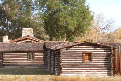
Fort Caspar is a military post at a crucial river crossing of the North Platte in Wyoming with reconstructed buildings from the 1800s. The site shows the original layout with barracks, storage buildings, and wooden walls to demonstrate how soldiers worked and lived at this remote location.

The post was founded in 1862 as Platte Bridge Station to protect telegraph lines and mail routes from attack. In 1865 it was renamed after Lieutenant Caspar Collins, who died in a battle at the river crossing.

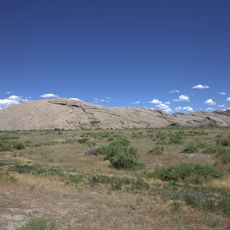
The site tells the story of Plains Indians and settlers who encountered each other at this river crossing. Visitors can see how different groups used this land and what daily life looked like for each.

The site is most accessible during warmer months, with limited operations during colder seasons. Visitors should prepare for outdoor walking across the grounds, as buildings are spread out and weather protection matters.

The place's name comes from a spelling mistake that stuck around for good. Lieutenant Collins's name was initially misspelled as Casper, but the error became so familiar that it stayed this way for the town and the fort.

The community of curious travelers

AroundUs brings together thousands of curated places, local tips, and hidden gems, enriched daily by 60,000 contributors worldwide.

Start exploring
Location
GPS coordinates
42.83667,-106.37111
Latest update
December 8, 2025 19:56
Around this place
Independence Rock
United States of America

Independence Rock

72.9 km
Teapot Rock
United States of America

Teapot Rock

44.4 km
Natrona County High School
United States of America

Natrona County High School

3.4 km
Casper Mountain
United States of America

Casper Mountain

10.5 km
Ayres Natural Bridge Park
United States of America

Ayres Natural Bridge Park

63.1 km
Pathfinder Dam
United States of America

Pathfinder Dam

57 km
National Historic Trails Interpretive Center
United States of America

National Historic Trails Interpretive Center

4.3 km
Edness K. Wilkins State Park
United States of America

Edness K. Wilkins State Park

16.1 km
Pathfinder National Wildlife Refuge
United States of America

Pathfinder National Wildlife Refuge

63.2 km
Dean Morgan Junior High School
United States of America

Dean Morgan Junior High School

3.3 km
Bishop House
United States of America

Bishop House

39.1 km
Masonic Temple
United States of America

Masonic Temple

4.1 km
Casper Downtown Historic District
United States of America

Casper Downtown Historic District

4 km
United States of America

Church of Saint Anthony

3.9 km
Midwest Oil Company Hotel
United States of America

Midwest Oil Company Hotel

4 km
Elks Lodge No. 1353
United States of America

Elks Lodge No. 1353

3.9 km
Odd Fellows Building
United States of America

Odd Fellows Building

4.2 km
Roosevelt School
United States of America

Roosevelt School

5.1 km
Ohio Oil Company Building
United States of America

Ohio Oil Company Building

4.3 km
North Casper Clubhouse
United States of America

North Casper Clubhouse

5.6 km
DUX Bessemer Bend Bridge
United States of America

DUX Bessemer Bend Bridge

14.9 km
Consolidated Royalty Building
United States of America

Consolidated Royalty Building

4.1 km
Commerce Block
United States of America

Commerce Block

40.9 km
Ewing T. Kerr Federal Building and U.S. Courthouse
United States of America

Ewing T. Kerr Federal Building and U.S. Courthouse

4.2 km
Tribune Building (Casper, Wyoming)
United States of America

Tribune Building (Casper, Wyoming)

4.2 km
Casper Motor Company-Natrona Motor Company
United States of America

Casper Motor Company-Natrona Motor Company

3.9 km
South Wolcott Street Historic District
United States of America

South Wolcott Street Historic District

4 km
America Stadium Theatre
United States of America

America Stadium Theatre

4 km
Show the full map
« Fort Caspar - Military post and heritage site in Casper, United States » is provided by Around Us (aroundus.com). Images and texts are derived from Wikimedia project under a Creative Commons license. You are allowed to copy, distribute, and modify copies of this page, under the conditions set by the license, as long as this note is clearly visible.

Discover hidden gems everywhere you go!

From secret cafés to breathtaking viewpoints, skip the crowded tourist spots and find places that match your style. Our app makes it easy with voice search, smart filtering, route optimization, and insider tips from travelers worldwide. Download now for the complete mobile experience.

Around Us App Screenshot

A unique approach to discovering new places

Le Figaro

All the places worth exploring

France Info

A tailor-made excursion in just a few clicks

20 Minutes

Around Us
Travel Guide & Maps
Download

Send to your phone

QR Code
1

Open the camera app on your mobile.

2

Point at the QR code with your camera. A notification will appear.

3

Tap the notification to open the link.