Enable Location

We need your location to show you interesting places around you

Discover nearby places

Find interesting locations and hidden gems around you

Precise directions

Get accurate directions and distances to places

Your location is never shared with other users. It's only used when you tap the location button.

Natrona County High School

Log in to your account

Start exploring — it's free

Trusted by 65,577 travelers worldwide

Continue with Google
Continue with Apple
or

We will send you a code to connect

By continuing, you accept our Terms and Conditions and our Privacy Policy

Check your inbox

We've sent a pincode in your inbox. Please enter the code below.

Discussion Reviews 1 Photos
8.9k Popularity

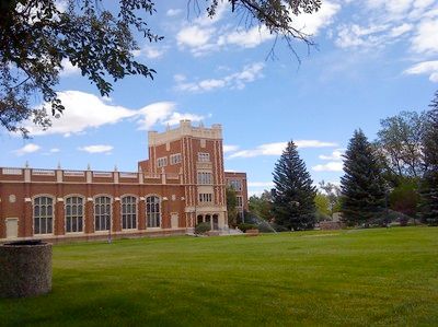
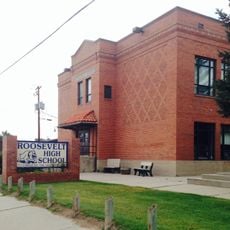
Natrona County High School, high school in Wyoming, United States

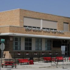
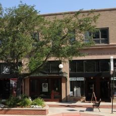
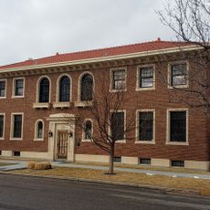
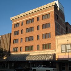
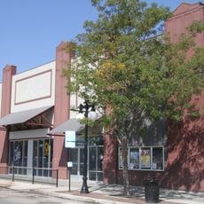
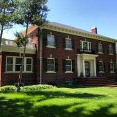
Natrona County High School is a public secondary school in Casper, Wyoming, listed on the National Register of Historic Places. The brick building sits in central Casper and stands as a notable example of early 20th-century school architecture found across the Great Plains.

The school building was constructed in the early 1920s, at a time when Casper was growing quickly thanks to Wyoming's oil boom. The expanding town needed a larger and more permanent school, and the building reflects the ambition of that era.

The school has long been a gathering point for the Casper community, and local pride in the building is easy to notice. Generations of Wyoming students have passed through its doors, giving it a place in the everyday life of the region that goes beyond its function as a classroom.

The building is easy to spot in central Casper and can be appreciated from the street without entering the campus. Since this is a working school, anyone wishing to see the exterior should be mindful of school hours and keep a respectful distance from the entrance.

The school is one of the few active educational institutions in Wyoming to appear on the National Register of Historic Places while still operating as a functioning school. This combination of official recognition and daily use makes it a rare case in the state.

The community of curious travelers

AroundUs brings together thousands of curated places, local tips, and hidden gems, enriched daily by 60,000 contributors worldwide.

Start exploring
Location
Inception
1896
GPS coordinates
42.84150,-106.33000
Latest update
March 3, 2026 08:19
Around this place
Independence Rock
United States of America

Independence Rock

76 km
Teapot Rock
United States of America

Teapot Rock

43.6 km
Fort Caspar
United States of America

Fort Caspar

3.4 km
Casper Mountain
United States of America

Casper Mountain

10 km
Ayres Natural Bridge Park
United States of America

Ayres Natural Bridge Park

59.9 km
Pathfinder Dam
United States of America

Pathfinder Dam

59.7 km
National Historic Trails Interpretive Center
United States of America

National Historic Trails Interpretive Center

2.8 km
Edness K. Wilkins State Park
United States of America

Edness K. Wilkins State Park

12.7 km
Pathfinder National Wildlife Refuge
United States of America

Pathfinder National Wildlife Refuge

66.2 km
Dean Morgan Junior High School
United States of America

Dean Morgan Junior High School

607 m
Bishop House
United States of America

Bishop House

39.4 km
Masonic Temple
United States of America

Masonic Temple

1.1 km
Casper Downtown Historic District
United States of America

Casper Downtown Historic District

880 m
United States of America

Church of Saint Anthony

491 m
Midwest Oil Company Hotel
United States of America

Midwest Oil Company Hotel

633 m
Elks Lodge No. 1353
United States of America

Elks Lodge No. 1353

545 m
Odd Fellows Building
United States of America

Odd Fellows Building

1.2 km
Roosevelt School
United States of America

Roosevelt School

2.8 km
Ohio Oil Company Building
United States of America

Ohio Oil Company Building

1.2 km
North Casper Clubhouse
United States of America

North Casper Clubhouse

2.7 km
DUX Bessemer Bend Bridge
United States of America

DUX Bessemer Bend Bridge

18.2 km
Consolidated Royalty Building
United States of America

Consolidated Royalty Building

977 m
Commerce Block
United States of America

Commerce Block

37.5 km
Ewing T. Kerr Federal Building and U.S. Courthouse
United States of America

Ewing T. Kerr Federal Building and U.S. Courthouse

1.1 km
Tribune Building (Casper, Wyoming)
United States of America

Tribune Building (Casper, Wyoming)

1 km
Casper Motor Company-Natrona Motor Company
United States of America

Casper Motor Company-Natrona Motor Company

837 m
South Wolcott Street Historic District
United States of America

South Wolcott Street Historic District

627 m
America Stadium Theatre
United States of America

America Stadium Theatre

998 m
Show the full map
Reviews
Share your experience

No review yet

Discussions
Start a discussion...

No discussion yet

« Natrona County High School - high school in Wyoming, United States » is provided by Around Us (aroundus.com). Images and texts are derived from Wikimedia project under a Creative Commons license. You are allowed to copy, distribute, and modify copies of this page, under the conditions set by the license, as long as this note is clearly visible.

Discover hidden gems everywhere you go!

From secret cafés to breathtaking viewpoints, skip the crowded tourist spots and find places that match your style. Our app makes it easy with voice search, smart filtering, route optimization, and insider tips from travelers worldwide. Download now for the complete mobile experience.

Around Us App Screenshot

A unique approach to discovering new places

Le Figaro

All the places worth exploring

France Info

A tailor-made excursion in just a few clicks

20 Minutes

Around Us
Travel Guide & Maps
Download

Send to your phone

QR Code
1

Open the camera app on your mobile.

2

Point at the QR code with your camera. A notification will appear.

3

Tap the notification to open the link.