Chest opened
+${chestReward.xp} XP
Explorer
NOUVEAU ×${chestReward.collectible.quantity}
tapez pour fermer
Chest locked

Open chests in the app

Around Us is built for your phone — chests unlock when you walk, explore and capture nearby places.

Enable Location

We need your location to show you interesting places around you

Discover nearby places

Find interesting locations and hidden gems around you

Precise directions

Get accurate directions and distances to places

Your location is never shared with other users. It's only used when you tap the location button.

Cheyenne Regional Airport

Log in to your account

Start exploring — it's free

Trusted by 72,993 travelers worldwide

Continue with Google
Continue with Apple
or

We will send you a code to connect

By continuing, you accept our Terms and Conditions and our Privacy Policy

Check your inbox

We've sent a pincode in your inbox. Please enter the code below.

Discussion Reviews 1 Photos
24.5k Popularity

Cheyenne Regional Airport, Regional airport in Cheyenne, United States.

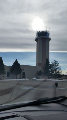
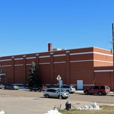
Cheyenne Regional Airport is a regional airport in Wyoming, United States, with two runways across approximately 1,060 acres of land. The facility serves both civilian flights and military operations for the Wyoming Air National Guard Base.

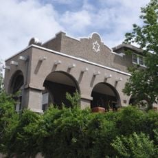
The Boeing/United Airlines Terminal and Hangar were built between 1929 and 1934 and listed on the National Register of Historic Places. These early buildings reflect the region's beginnings in commercial aviation.

The terminal displays local Wyoming art and sells regional products in its shops, giving travelers a sense of the state's heritage. You can experience these connections while waiting for your flight.

The airport offers free parking and a short walk between the parking area and the modern terminal building. Getting around the terminal is straightforward since the building is compact and easy to navigate.

During World War II, the airport played a role in aviation technology through the development of a specialized turret for the B-17 bomber, named after Cheyenne. This military connection shows how local aviation facilities contributed to the nation's defense industry.

The community of curious travelers

AroundUs brings together thousands of curated places, local tips, and hidden gems, enriched daily by 60,000 contributors worldwide.

Start exploring
Location
Inception
January 10, 1937
Elevation above the sea
1,878 m
Operator
Cheyenne Regional Airport Board
GPS coordinates
41.15720,-104.81163
Latest update
December 20, 2025 12:36
Around this place
Wyoming State Capitol
United States of America

Wyoming State Capitol

2 km
Cheyenne Botanic Gardens
United States of America

Cheyenne Botanic Gardens

1.6 km
Cheyenne Botanic Gardens
United States of America

Cheyenne Botanic Gardens

1.6 km
Wyoming State Museum
United States of America

Wyoming State Museum

2 km
Cheyenne High School
United States of America

Cheyenne High School

1.5 km
Boeing/United Airlines Terminal Building, Hangar and Fountain
United States of America

Boeing/United Airlines Terminal Building, Hangar and Fountain

827 m
William Sturgis House
United States of America

William Sturgis House

2.3 km
Rainsford Historic District
United States of America

Rainsford Historic District

2 km
Storey Gymnasium
United States of America

Storey Gymnasium

1.4 km
Holliday Park
United States of America

Holliday Park

2.3 km
Crook House
United States of America

Crook House

2 km
Lakeview Historic District
United States of America

Lakeview Historic District

1.7 km
Deming School
United States of America

Deming School

1.6 km
Capitol North Historic District
United States of America

Capitol North Historic District

1.7 km
Moreton Frewen House
United States of America

Moreton Frewen House

1.8 km
Castle on 19th Street
United States of America

Castle on 19th Street

2 km
Cheyenne Veterans Administration Hospital
United States of America

Cheyenne Veterans Administration Hospital

2.4 km
Mabel Fincher School
United States of America

Mabel Fincher School

1.7 km
Baxter Ranch Headquarters Buildings
United States of America

Baxter Ranch Headquarters Buildings

2.1 km
United States of America

Keefe Row

2 km
Johnson Public School
United States of America

Johnson Public School

1.5 km
United States of America

Van Tassell Carriage Barn

2.2 km
Cheyenne Artists Guild
United States of America

Cheyenne Artists Guild

2.2 km
Mylar Park
United States of America

Mylar Park

1 km
High Plains Arboretum
United States of America

High Plains Arboretum

1.5 km
Paul Smith Childrens Village
United States of America

Paul Smith Childrens Village

1.5 km
United States of America

Amphitheatre

1.6 km
United States of America

Sculpture, Work of art

1 km
Show the full map
Reviews
Share your experience

No review yet

Discussions
Start a discussion...

No discussion yet

« Cheyenne Regional Airport - Regional airport in Cheyenne, United States » is provided by Around Us (aroundus.com). Images and texts are derived from Wikimedia project under a Creative Commons license. You are allowed to copy, distribute, and modify copies of this page, under the conditions set by the license, as long as this note is clearly visible.

Discover hidden gems everywhere you go!

From secret cafés to breathtaking viewpoints, skip the crowded tourist spots and find places that match your style. Our app makes it easy with voice search, smart filtering, route optimization, and insider tips from travelers worldwide. Download now for the complete mobile experience.

Around Us App Screenshot

A unique approach to discovering new places

Le Figaro

All the places worth exploring

France Info

A tailor-made excursion in just a few clicks

20 Minutes

Around Us
Travel Guide & Maps
Download

Send to your phone

QR Code
1

Open the camera app on your mobile.

2

Point at the QR code with your camera. A notification will appear.

3

Tap the notification to open the link.