Enable Location

We need your location to show you interesting places around you

Discover nearby places

Find interesting locations and hidden gems around you

Precise directions

Get accurate directions and distances to places

Your location is never shared with other users. It's only used when you tap the location button.

Interstate Highway Bridge

Log in to your account

Start exploring — it's free

Trusted by 63,386 travelers worldwide

Continue with Google
Continue with Apple
or

We will send you a code to connect

By continuing, you accept our Terms and Conditions and our Privacy Policy

Check your inbox

We've sent a pincode in your inbox. Please enter the code below.

Interstate Highway Bridge
Discussion Reviews 1 Photos
1.3k Popularity

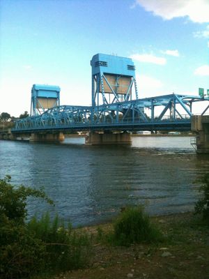
Interstate Highway Bridge, Vertical-lift road bridge between Nez Perce County and Asotin County, United States.

The Interstate Highway Bridge is a vertical-lift road bridge that crosses the Snake River, connecting Lewiston, Idaho with Clarkston, Washington. The metal structure painted in blue features a movable section that can be raised to allow river vessels to pass underneath.

The bridge was completed in 1939 to meet the growing need for reliable transportation between Idaho and Washington during the early twentieth century. Its construction addressed the economic necessity of establishing a stable link between the two states.

The bridge serves as a daily crossing point where residents and travelers from Idaho and Washington meet and interact during their journeys. It represents a practical link between two communities whose local economies and social connections depend on regular movement across the river.

The bridge's movable lift mechanism allows river traffic to pass while maintaining regular vehicle flow between the two states. Visitors driving across should be aware that occasional vessel passages may cause brief interruptions to road traffic.

The Library of Congress maintains an extensive photographic collection documenting the bridge within the landscape of the Snake River valley. This archive provides a historical visual record of the structure and its surroundings across multiple decades.

The community of curious travelers

AroundUs brings together thousands of curated places, local tips, and hidden gems, enriched daily by 60,000 contributors worldwide.

Start exploring
Location
Location
GPS coordinates
46.42042,-117.03588
Latest update
December 14, 2025 18:06
Around this place
Kibbie Dome
United States of America

Kibbie Dome

34.1 km
Nez Perce National Historical Park
United States of America

Nez Perce National Historical Park

16.6 km
Lewiston Hill
United States of America

Lewiston Hill

6.6 km
United States of America

University of Idaho Arboretum and Botanical Garden

33.7 km
Fort Lapwai
United States of America

Fort Lapwai

17.1 km
MacLean Field
United States of America

MacLean Field

34.1 km
Sternwheeler Jean
United States of America

Sternwheeler Jean

5.8 km
Full Gospel Church
United States of America

Full Gospel Church

8.9 km
St. Boniface Church, Convent and Rectory
United States of America

St. Boniface Church, Convent and Rectory

14 km
Sigma Alpha Epsilon Fraternity House
United States of America

Sigma Alpha Epsilon Fraternity House

34.1 km
Cordelia Lutheran Church
United States of America

Cordelia Lutheran Church

28.7 km
Gaylord Thompson House
United States of America

Gaylord Thompson House

3.1 km
First Presbyterian Church
United States of America

First Presbyterian Church

18 km
21 Ranchhouse
United States of America

21 Ranchhouse

25.8 km
Ridenbaugh Hall
United States of America

Ridenbaugh Hall

33.9 km
Indian Timothy Memorial Bridge
United States of America

Indian Timothy Memorial Bridge

13.6 km
Nave Apartments
United States of America

Nave Apartments

1.3 km
James Asposas House
United States of America

James Asposas House

2.7 km
Clarkston Public Library
United States of America

Clarkston Public Library

1.3 km
Frank Booth House
United States of America

Frank Booth House

2.9 km
Kappa Sigma Fraternity, Gamma Theta Chapter
United States of America

Kappa Sigma Fraternity, Gamma Theta Chapter

34.1 km
Genesee Exchange Bank
United States of America

Genesee Exchange Bank

16.8 km
William and Elizabeth McLaren House
United States of America

William and Elizabeth McLaren House

2.7 km
C. C. Van Arsdol House
United States of America

C. C. Van Arsdol House

2.7 km
Agnes M. Tamblyn House
United States of America

Agnes M. Tamblyn House

2.8 km
Temple Theatre
United States of America

Temple Theatre

1 km
Nu Art Theater
United States of America

Nu Art Theater

34.6 km
Kenworthy Performing Arts Centre
United States of America

Kenworthy Performing Arts Centre

34.6 km
Show the full map
Reviews
Share your experience

No review yet

Discussions
Start a discussion...

No discussion yet

« Interstate Highway Bridge - Vertical-lift road bridge between Nez Perce County and Asotin County, United States » is provided by Around Us (aroundus.com). Images and texts are derived from Wikimedia project under a Creative Commons license. You are allowed to copy, distribute, and modify copies of this page, under the conditions set by the license, as long as this note is clearly visible.

Discover hidden gems everywhere you go!

From secret cafés to breathtaking viewpoints, skip the crowded tourist spots and find places that match your style. Our app makes it easy with voice search, smart filtering, route optimization, and insider tips from travelers worldwide. Download now for the complete mobile experience.

Around Us App Screenshot

A unique approach to discovering new places

Le Figaro

All the places worth exploring

France Info

A tailor-made excursion in just a few clicks

20 Minutes

Around Us
Travel Guide & Maps
Download

Send to your phone

QR Code
1

Open the camera app on your mobile.

2

Point at the QR code with your camera. A notification will appear.

3

Tap the notification to open the link.