Enable Location

We need your location to show you interesting places around you

Discover nearby places

Find interesting locations and hidden gems around you

Precise directions

Get accurate directions and distances to places

Your location is never shared with other users. It's only used when you tap the location button.

Manning-Rye Covered Bridge

Log in to your account

Start exploring — it's free

Trusted by 62,353 travelers worldwide

Continue with Google
Continue with Apple
or

We will send you a code to connect

By continuing, you accept our Terms and Conditions and our Privacy Policy

Check your inbox

We've sent a pincode in your inbox. Please enter the code below.

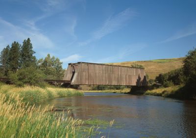
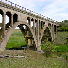
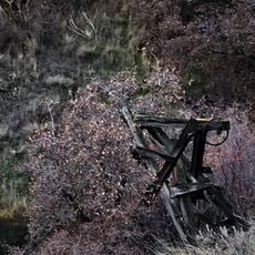
Manning-Rye Covered Bridge, Wooden railway bridge in Whitman County, United States

The Manning-Rye Covered Bridge is a wooden railway bridge spanning the Palouse River with a single timber Howe truss frame supported by pile abutments. The structure was later modified to carry automobiles by replacing the train rails with wooden planking.

The bridge was built in 1922 by the Spokane and Inland Empire Railroad to carry train traffic across the river. When the Great Northern Railroad transferred it in 1967, private owners eventually converted it for vehicle use.

The bridge demonstrates how people adapted traditional construction methods to support railway operations in the early 1900s across the region.

Access to this bridge is limited as it sits on private property and has been modified for vehicle use over many years. Visitors should arrange advance permission with property owners and take proper precautions when inspecting the structure.

The bridge had an open top section rather than a fully enclosed roof to allow overhead electrical power lines for trains to pass through. This design difference from typical covered bridges shows how the structure was specifically engineered for electric railway operations.

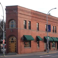
The community of curious travelers

AroundUs brings together thousands of curated places, local tips, and hidden gems, enriched daily by 60,000 contributors worldwide.

Start exploring
Location
Inception
1922
GPS coordinates
46.92839,-117.41534
Latest update
December 14, 2025 13:04
Around this place
Martin Stadium
United States of America

Martin Stadium

29.3 km
Kibbie Dome
United States of America

Kibbie Dome

37.7 km
Steptoe Butte
United States of America

Steptoe Butte

14.7 km
Palouse to Cascades State Park Trail
United States of America

Palouse to Cascades State Park Trail

35.8 km
Beasley Coliseum
United States of America

Beasley Coliseum

29.1 km
Lower Granite Dam
United States of America

Lower Granite Dam

29.8 km
Steptoe Battlefield State Park Heritage Site
United States of America

Steptoe Battlefield State Park Heritage Site

33.6 km
United States of America

University of Idaho Arboretum and Botanical Garden

38.2 km
MacLean Field
United States of America

MacLean Field

38 km
Jewett Observatory
United States of America

Jewett Observatory

29.9 km
Pullman Flatiron Building
United States of America

Pullman Flatiron Building

28.4 km
Bryan Hall
United States of America

Bryan Hall

29.1 km
Rosalia Railroad Bridge
United States of America

Rosalia Railroad Bridge

32.9 km
Rock Creek
United States of America

Rock Creek

33.5 km
Old Post Office
United States of America

Old Post Office

28.6 km
Dumas Seed Company warehouse
United States of America

Dumas Seed Company warehouse

28.2 km
Cordova Theatre
United States of America

Cordova Theatre

28.1 km
United Presbyterian Church
United States of America

United Presbyterian Church

28.5 km
Interior Grain Tramway
United States of America

Interior Grain Tramway

29.8 km
Holy Trinity Episcopal Church
United States of America

Holy Trinity Episcopal Church

25.8 km
Central Service Station
United States of America

Central Service Station

34.4 km
William Swain House
United States of America

William Swain House

28.2 km
McConnell–McGuire Building
United States of America

McConnell–McGuire Building

38.3 km
Codger Pole
United States of America

Codger Pole

6.8 km
Audian Theatre
United States of America

Audian Theatre

28.5 km
12-inch Alvan Clark & Sons telescope
United States of America

12-inch Alvan Clark & Sons telescope

29.9 km
St. Ignatius Hospital
United States of America

St. Ignatius Hospital

7.5 km
Rose Theatre
United States of America

Rose Theatre

7 km
Show the full map
« Manning-Rye Covered Bridge - Wooden railway bridge in Whitman County, United States » is provided by Around Us (aroundus.com). Images and texts are derived from Wikimedia project under a Creative Commons license. You are allowed to copy, distribute, and modify copies of this page, under the conditions set by the license, as long as this note is clearly visible.

Discover hidden gems everywhere you go!

From secret cafés to breathtaking viewpoints, skip the crowded tourist spots and find places that match your style. Our app makes it easy with voice search, smart filtering, route optimization, and insider tips from travelers worldwide. Download now for the complete mobile experience.

Around Us App Screenshot

A unique approach to discovering new places

Le Figaro

All the places worth exploring

France Info

A tailor-made excursion in just a few clicks

20 Minutes

Around Us
Travel Guide & Maps
Download

Send to your phone

QR Code
1

Open the camera app on your mobile.

2

Point at the QR code with your camera. A notification will appear.

3

Tap the notification to open the link.