Enable Location

We need your location to show you interesting places around you

Discover nearby places

Find interesting locations and hidden gems around you

Precise directions

Get accurate directions and distances to places

Your location is never shared with other users. It's only used when you tap the location button.

Rosalia Railroad Bridge

Log in to your account

Start exploring — it's free

Trusted by 62,883 travelers worldwide

Continue with Google
Continue with Apple
or

We will send you a code to connect

By continuing, you accept our Terms and Conditions and our Privacy Policy

Check your inbox

We've sent a pincode in your inbox. Please enter the code below.

Discussion Reviews 1 Photos
1.4k Popularity

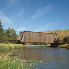
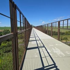
Rosalia Railroad Bridge, Railway bridge in Rosalia, Washington, US.

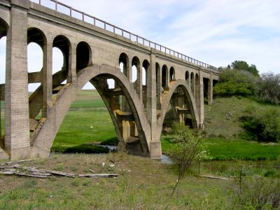
The Rosalia Railroad Bridge is a concrete arch bridge in Washington that crosses multiple transportation routes. It has two main spans separated by an embankment, with the western section passing over Pine Creek.

This concrete arch bridge was built in 1915 by the Chicago, Milwaukee, St. Paul and Pacific Railroad. It replaced an earlier wooden trestle and was added to the National Register in 1982.

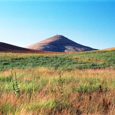
The bridge stands near a historic battlefield site and shows how the railroad opened up the region. You can see here how important rail connections were for settling and developing the area.

The location is easy to find since the bridge crosses multiple roads and rail lines. Access is best from the state highway that runs beneath the structure.

What makes this bridge special is its design spanning over competing railroad lines. The vertical stacking shows a clever solution to limited space in the area.

The community of curious travelers

AroundUs brings together thousands of curated places, local tips, and hidden gems, enriched daily by 60,000 contributors worldwide.

Start exploring
Location
GPS coordinates
47.22220,-117.36300
Latest update
December 14, 2025 17:02
Around this place
Steptoe Butte
United States of America

Steptoe Butte

21.7 km
Palouse to Cascades State Park Trail
United States of America

Palouse to Cascades State Park Trail

8.6 km
Manito Park and Botanical Gardens
United States of America

Manito Park and Botanical Gardens

46.2 km
Heyburn State Park
United States of America

Heyburn State Park

47.7 km
Cathedral of St. John the Evangelist
United States of America

Cathedral of St. John the Evangelist

47.2 km
Turnbull National Wildlife Refuge
United States of America

Turnbull National Wildlife Refuge

27.1 km
Coeur d’Alene Casino
United States of America

Coeur d’Alene Casino

37.1 km
McCroskey State Park
United States of America

McCroskey State Park

35.8 km
Steptoe Battlefield State Park Heritage Site
United States of America

Steptoe Battlefield State Park Heritage Site

717 m
Knickerbocker
United States of America

Knickerbocker

48 km
Mary Queen of Heaven Roman Catholic Church
United States of America

Mary Queen of Heaven Roman Catholic Church

47.1 km
Manning-Rye Covered Bridge
United States of America

Manning-Rye Covered Bridge

32.9 km
Marycliff-Cliff Park Historic District
United States of America

Marycliff-Cliff Park Historic District

47.4 km
Rock Creek
United States of America

Rock Creek

30.5 km
Coeur d'Alene Mission of the Sacred Heart
United States of America

Coeur d'Alene Mission of the Sacred Heart

35 km
St. Aidan's Anglican Church
United States of America

St. Aidan's Anglican Church

47.7 km
Holy Trinity Episcopal Church
United States of America

Holy Trinity Episcopal Church

40.6 km
Coolidge–Rising House
United States of America

Coolidge–Rising House

47.6 km
Breslin
United States of America

Breslin

47.7 km
Cheney Odd Fellows Hall
United States of America

Cheney Odd Fellows Hall

33.5 km
Moore-Turner Garden
United States of America

Moore-Turner Garden

47.6 km
Edward and Ida Soncarty Barn
United States of America

Edward and Ida Soncarty Barn

42 km
Codger Pole
United States of America

Codger Pole

38.3 km
BiMart Arena - Cheney Rodeo
United States of America

BiMart Arena - Cheney Rodeo

37.1 km
St. Ignatius Hospital
United States of America

St. Ignatius Hospital

39.1 km
Rose Theatre
United States of America

Rose Theatre

38.6 km
Plummer Point Picnic Shelter
United States of America

Plummer Point Picnic Shelter

47 km
Tekoa Train Trestle
United States of America

Tekoa Train Trestle

21.5 km
Show the full map
« Rosalia Railroad Bridge - Railway bridge in Rosalia, Washington, US » is provided by Around Us (aroundus.com). Images and texts are derived from Wikimedia project under a Creative Commons license. You are allowed to copy, distribute, and modify copies of this page, under the conditions set by the license, as long as this note is clearly visible.

Discover hidden gems everywhere you go!

From secret cafés to breathtaking viewpoints, skip the crowded tourist spots and find places that match your style. Our app makes it easy with voice search, smart filtering, route optimization, and insider tips from travelers worldwide. Download now for the complete mobile experience.

Around Us App Screenshot

A unique approach to discovering new places

Le Figaro

All the places worth exploring

France Info

A tailor-made excursion in just a few clicks

20 Minutes

Around Us
Travel Guide & Maps
Download

Send to your phone

QR Code
1

Open the camera app on your mobile.

2

Point at the QR code with your camera. A notification will appear.

3

Tap the notification to open the link.